Earth ChangesS


Attention

Gigantic Sinkhole Opens Up In Brooklyn And Nearly Swallows Parked Car

Image
© @gazawia via TwitterBay Ridge, Brooklyn sinkhole: Does anyone out there still think the rate at which these things are appearing is 'normal'?
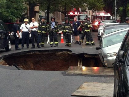
A large sinkhole opened up Wednesday afternoon in Brooklyn, creating a close call for one family that had just parked their car in its vicinity.

The 20-foot-deep by 20-foot-wide hole, which formed at around 6 p.m., is located between 4th and 5th avenues in Bay Ridge. Crews stabilized the situation Wednesday night, but they may be working to fill in the massive hole for days, officials said.

Maddie Flood said she and her mother, Annette, had just parked their car shortly before it was partially swallowed by the hole, leaving it leaning "like the Titanic."

"We're so blessed. If we were five minutes later or anything, we could have been in the hole," she told 1010 WINS' Aaron Gerberg.

Bizarro Earth

New Zealand's White Island volcano showing growing signs of unrest

Image
© Unknown
White Island volcano is showing signs of increased activity, GNS Science says.

The volcano, about 49 kilometres off the coast of Whakatane, is a popular tourist spot, but GNS volcanologist Michael Rosenberg says those visiting it should be cautious even though the alert level for the island had not changed.

"Eruptions can occur at any time with little or no warning. The recent changes in activity suggest that the hydrothermal system has become unstable, and as a result the risk has increased," Rosenberg said.

GNS Science has changed the volcano's code from a "normal, non eruptive state" to "experiencing signs of elevated unrest above known background levels".

The volcano's lake level quickly rose by about three to five metres sometime between Friday and Saturday last week, exposing a "vigorous" flow of gas and steam into the air, Rosenberg said.

It has risen in the past, but took much longer than the 24 hours it took to rise three to five metres on Friday and Saturday, he said.

During the past few weeks there had also been some minor volcanic tremor, including several hours on Saturday, Monday and Tuesday.
Bizarro Earth

Growing risk for large magnitude earthquake for NW Pacific coast

Image
© Unknown
The western US state of Oregon has a 40 percent chance in the next half-century of suffering a massive earthquake on the scale of Japan's 2011 disaster, a study said Wednesday. The Pacific Northwest -- from the Oregon-California border to Vancouver Island in Canada -- has endured 19 huge earthquakes of around 8.7-9.2 magnitude over the past 10,000 years, Oregon State University researchers said.

An additional 22 major earthquakes have impacted only the southern part of the so-called Cascadia fault that runs from the Oregon areas of Coos Bay to Newport, the study said. "The southern margin of Cascadia has a much higher recurrence level for major earthquakes than the northern end and, frankly, it is overdue for a rupture," the study's lead author Chris Goldfinger said in a statement.

Bizarro Earth

Typhoon Saola leaves 24 dead in Philippines, 5 in Taiwan - thousands displaced

Typhoon "Gener" (international name: Saola) left at least 24 persons dead and almost 180,000 displaced as of Thursday afternoon, disaster management officials said. The National Disaster Risk Reduction and Management Council (NDRRMC) said new fatalities were recorded in Ilocos Sur, Quezon, Bulacan, Negros Occidental, Iloilo, Negros Oriental and Misamis Oriental.

The latest fatality was identified as Venice Sinopen, a grade three pupil from San Ramon Sigay, Ilocos Sur, who died of drowning. In Bataan, a certain Angelito Bicoy, 59, drowned and was recovered along the shoreline of barangay Sisiman in Mariveles last Tuesday.

Two new fatalities were also recorded in Bulacan namely Efren Salvacion, 41, of Obando and Patrick dela Rosa, 12, of Marilao. Both died of drowning. Five persons from Visayas and Mindanao died after they were hit by fallen trees during the height of the typhoon.

Bizarro Earth

Deep Earthquake Magnitude 6.1 Strikes Central Peru

A deep, magnitude-6.1 earthquake shook people awake in Peru's central jungle region early Thursday and was also felt in the capital, Lima. There were no immediate reports of damage or injuries. Civil defense official Jairo Goreau in the provincial capital of Pucallpa near the epicenter said some power outages were reported as well as telephone line congestion but city inspectors had so far encountered no damage.

The quake struck at 4:38 a.m. (9:38 GMT), 21 miles (34 kilometers) east of Pucallpa, a city of more than 270,000 people, at a depth of 89 miles (143 kilometers), according to the U.S. Geological Survey.

Bizarro Earth

Global Consequences of America's Drought

Image
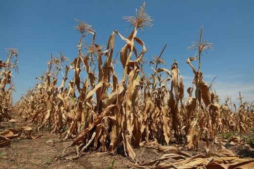
© Getty ImagesDescription: Corn plants struggle to survive in a drought-stricken farm field on July 19, near Oakton, Indiana
There's far more at stake than the price of corn on the cob and soy milk.


Most people are aware of the historic, unrelenting drought tightening its grip on the United States. But too few are seriously contemplating what this means, not just for America, but for the world.

To most people in wealthier nations, drought simply means ridiculously hot weather, parched lawns and plants, and perhaps a higher-than-normal electric bill. A lack of rain is an annoyance, like an itch, uncomfortable, irritating. Few consider drought to be catastrophic, even fatal.

It wasn't always this way. There was a time when people understood that severe, prolonged drought meant extreme hardship, suffering and, if it persisted, eventual death. People understood that without rain, crops, fruit trees and pastures died, lakes and watering holes dried up, livestock starved. In the past, when a drought tightened its grip, farmers and their families, and even entire towns and cities, recognized early that they had two options: relocate or starve.

Although we're in the 21st century, this reality has not changed. Except that unlike yesteryear, people today are ignorant to the fact that extreme drought kills.

Comment: Obeisance to the laws of a biblical God are unlikely to make a difference at this point in the cycle of climate change. The earth has undergone many such cycles in the past and no matter how much praying is done, the cosmos will undertake the necessary steps to cleanse itself of the inherent pathology extant on planet earth at this time.
2012: Something Is Going On!
Reign of Fire: Meteorites, Wildfires, Planetary Chaos and the Sixth Extinction
2012 - Collective Awakening or End of the World?


Sun

Half of US counties deemed natural disaster areas


Just over half of the counties in the U.S. are now labeled "natural disaster areas" after the U.S. Department of Agriculture on Wednesday added 218 counties in 12 states to the list.

With drought drying up food crops and animal feedstock, the USDA also said it was allowing haying and grazing on 3.8 million protected acres, many of them wetlands, and that it had received assurances from insurers that they would forgo interest payments on unpaid farm loans for up to 30 days.

"The assistance announced today will help U.S. livestock producers dealing with climbing feed prices, critical shortages of hay and deteriorating pasturelands," Agriculture Secretary Tom Vilsack said in a statement announcing the moves.

Across 32 states, ranchers and farmers in 1,584 counties -- 50.3 percent of the total -- are now eligible for low-interest loans. Some 90 percent of those counties were listed due to drought conditions.

That's a new record and one that's been broken repeatedly in recent weeks as more counties have been added. The declarations first started on July 12.

Comment: Worst Drought Since 1950s in Continental U.S.
Drought categories rise by 50% - in 1 week


Arrow Up

Amazing Photo: 'Fire Rainbow' Over South Florida

Fire Rainbow
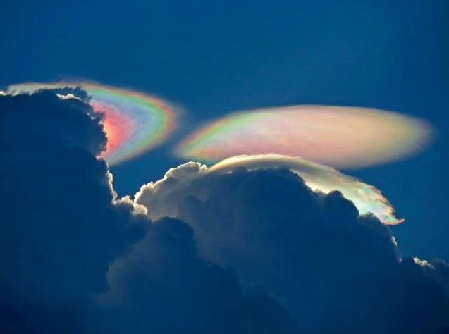
© Marnie Levy Williams / WPTVThis "fire rainbow," or iridescent cloud, was captured in a photo taken on Tuesday (July 31) over South Florida.
So-called "fire rainbows" are neither on fire nor are they rainbows, but they sure are stunning.

They are technically known as iridescent clouds, a relatively rare phenomenon caused by clouds of water droplets of nearly uniform size, according to a release by NASA. These clouds diffract, or bend, light in a similar manner, which separates out light into different wavelengths, or colors.

That makes them similar to rainbow-colored glories, which are also formed by diffraction, and also produce an oscillating pattern of colors ranging from blue to green to red to purple and back to blue again.

Although iridescent clouds have rainbow-like colors, the way light is scattered to produce them is slightly different. Rainbows are formed by refraction and reflection. When light is refracted, it is bent by passing through mediums of different densities, such as water or a prism. Reflected light bounces off a surface at an angle equal to the angle it hit the surface at. Diffraction, though, involves light waves being scattered into a ring-like pattern.

Arrow Up

Record high temperatures roast Oklahoma - heat warnings issued for numerous counties

Image
© Oklahoma Forestry Services
Tulsa's temperatures are rising and are showing no signs of letting up yet. The National Weather Service forecasts highs near 113 degrees this afternoon; 109 on Thursday; 107 on Friday; and 102 on Saturday for Tulsa. Highs are expected to finally sink to the 90s again by Sunday, when a slight chance of showers and thunderstorms is forecast for Tulsa.

Tulsa reached its hottest temperature of the calendar year on Tuesday, 112 degrees. Tulsa finished the month of July with 1.38 inches of rain, almost 2 inches below normal for the month. Excessive heat warning The weather service extended its heat warning for northeast Oklahoma until 7 p.m. Friday.

Cloud Lightning

2nd highest altitude twister ever recorded in U.S, touches down in Colorado

A twister that touched down in Colorado's high-country on Saturday is estimated to be the second-highest tornado ever recorded in the U.S. by the National Weather Service.

There were four different reported sightings of the high-altitude hit the northeast side of Mount Evans - a prominent mountain located about 60 miles west of Denver. The National Weather Service estimates the tornado's touched down at about 11,900 feet in elevation.

Bob Glancy, a National Weather Service meteorologist in Boulder, Colo., told NBC News that this tornado above the treeline is "not unheard of," but "just unusual." Most tornadoes in high terrain are weak, he said.

Image
© Josh DeereThe tornado that touched down on Colorado's Mount Evans last weekend is the second-highest ever recorded by the National Weather Service.