Earth ChangesS


Bizarro Earth

Earthquake Magnitude 6.0 - SW of Sarangani, Philippines

Philippines Quake_171012
© USGS
Event Time
2012-10-17 04:42:31 UTC
2012-10-17 12:42:31 UTC+08:00 at epicenter

Location

4.191°N 124.573°E depth=337.4km (209.7mi)

Nearby Cities
166km (103mi) SW of Sarangani, Philippines
193km (120mi) SSW of Glan, Philippines
199km (124mi) S of Kiamba, Philippines
212km (132mi) SSW of Malapatan, Philippines
1071km (665mi) E of Bandar Seri Begawan, Brunei

Technical Details

Bizarro Earth

Earthquake Magnitude 4.0 - 6km NNE of Waterboro, Maine

Image
© USGS
Event Time
2012-10-16 19:12:22 UTC-04:00 at epicenter
2012-10-16 16:12:22 UTC-07:00 system time

Location
43.592°N 70.676°W depth=6.6km (4.1mi)

Nearby Cities
6km (4mi) NNE of Waterboro, Maine
21km (13mi) WNW of Biddeford, Maine
21km (13mi) WNW of Saco, Maine
23km (14mi) W of West Scarborough, Maine
81km (50mi) ENE of Concord, New Hampshire

Galaxy

More strange sky sounds recorded, this time over Denmark on 11 October 2012


We also heard the sound of northern Sweden when we lived there, but it sounded more like a train. But it also came from the sky there. I will put this sound on our page too soon...

At first we thought it was a storm or hurricane coming above the city. When we opened the door it was completely calm. We could hear over the whole sky there was a hiss and a loud strange sound and noise, it was extremely loud. It lasted more than 2 hours and during the time I film is between 2 at night and 3 at night. I could not sleep for the weird sound and i was going to open the window to hear what it was again. But there was nothing to explain how strange it was... Experiments that governments and the military are involved in...??

Comment: Sott Report: Strange Noises in the Sky: Trumpets of the Apocalypse?


Blue Planet

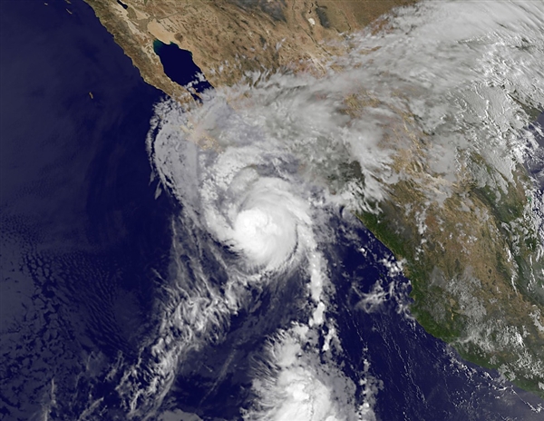
Hurricane Paul to hit Baja California coast Tuesday afternoon

Image
© NASA/AFP/Getty ImagesThis satellite-based image shows Hurricane Paul early Tuesday.
Hurricane Paul was expected to make landfall Tuesday afternoon along a lightly populated area of Mexico's Baja California.

Early Tuesday, the Category 2 hurricane was about 70 miles south of Cabo San Lazaro and was moving north-northeast at 21 miles per hour with maximum wind speeds of 105 mph, the U.S. National Hurricane Center reported.

Up to 10 inches of rain in some places could trigger flooding or mudslides, the center said, warning the storm would cause dangerous coastal waves.

Mexico issued a hurricane warning from Santa Fe northward to Punta Abreojos on the country's western Baja peninsula, the center said. On the east coast, a hurricane warning stretched from Mulege to San Evaristo.

While Paul was expected to weaken once it makes landfall, it should stay over Baja California for up to 36 hours, the hurricane center said.

The storm is not expected to hit the tourist resorts of Los Cabos.

Some rain from Paul should even make it to south Texas on Tuesday, weather.com reported.

Snowflake Cold

If extreme weather becomes the norm, starvation awaits

Image
With forecasts currently based only on averages, food production may splutter out even sooner than we feared

I believe we might have made a mistake: a mistake whose consequences, if I am right, would be hard to overstate. I think the forecasts for world food production could be entirely wrong. Food prices are rising again, partly because of the damage done to crops in the northern hemisphere by ferocious weather. In the US, Russia and Ukraine, grain crops were clobbered by remarkable droughts. In parts of northern Europe, such as the UK, they were pummelled by endless rain.

Even so, this is not, as a report in the Guardian claimed last week, "one of the worst global harvests in years". It's one of the best. World grain production last year was the highest on record; this year's crop is just 2.6% smaller. The problem is that, thanks to the combination of a rising population and the immoral diversion of so much grain into animal feed and biofuels, a new record must be set every year. Though 2012's is the third biggest global harvest in history (after 2011 and 2008), this is also a year of food deficit, in which we will consume 28m tonnes more grain than farmers produced. If 2013's harvest does not establish a new world record, the poor are in serious trouble.

So the question of how climate change might alter food production could not be more significant. It is also extremely hard to resolve, and relies on such daunting instruments as "multinomial endogenous switching regression models". The problem is that there are so many factors involved. Will extra rainfall be cancelled out by extra evaporation? Will the fertilising effect of carbon dioxide be more powerful than the heat damage it causes? To what extent will farmers be able to adapt? Will new varieties of crops keep up with the changing weather?

Comment: And here we reach the crux of the matter. The man-made global warming nonsense is intended to produce precisely that reaction in people - simultaneously terrify them with long-term projections of slow upward trends way into the future, thereby leaving them feeling "oddly reassured". It's false hope, of course, because it provides a smokescreen that explains away the increasing extremes that people like the above author are noticing.

Forget 50 years from now! The signs of environmental stress we're seeing now pertain to choices we need to make now... like RIGHT NOW!


Cloud Lightning

"Rare" for October: Tropical Cyclone Anais rages in the Indian Ocean

Tropical Cyclone Anais is estimated to have a maximum wind of 115 mph as of early this morning, which is equivalent to a category 3 hurricane in the Atlantic Ocean. The southwestern Indian Ocean is prone to tropical cyclones but what makes Anais so rare is that it is occurring in October, which is early springtime in the southern Hemisphere.
Image
The peak period for tropical events in this part of the world is normally during our winter months of January-March. Anais is forecast to move southwest in the general direction of Madagascar for the next five days and weaken as it moves into cooler waters and unfavorable winds.

Bizarro Earth

"Hundreds" of earthquakes swarm near Reno, Nevada, as schools practice 'shakeout'

Image
© USGS
University of Nevada, Reno seismologists have reported 115 small earthquakes in the Spanish Springs area since Oct. 8. It's the largest reported batch of earthquakes in a related location near Reno since the 2008 earthquakes in Verdi and Mogul, which included a magnitude 5.0 quake, UNR seismologist Diane dePolo said.

Nevada has about 30 to 50 reported earthquakes each day, she said. The Spanish Springs earthquakes have not registered higher than a magnitude 1.0, but that doesn't mean a larger earthquake isn't possible, she said.

To push earthquake preparedness, each Nevada public school is expected to participate at 10:18 a.m. Thursday in the third annual Great Nevada Shakeout, district officials said.

Snowflake

First measurable snow in Valdez, Alaska, occurred 17 days earlier than last season

Valdez, Alaska snow
© UnknownSnow surrounds this home in Valdez, Alaska on Jan. 9, 2012.
Why on earth are we starting off with the photo above? It's not January!Saturday, Valdez, Alaska, America's snowiest city, witnessed its first measurable snow of the season, picking up 1.6" accumulation. This may have inspired a sense of dread in the area, given last season.

A whopping 438" of snow fell in Valdez last season. That's 36 feet of total snow accumulation! The 2011-2012 season delivered over 100" above the average (326").

In fact, after a whopping 98" of snow fell just in the first 12 days of January 2012, the National Guard had to be called in to help rescue folks buried in both Valdez and nearby, Cordova, AK. Incredibly, snow invaded a home of one unlucky Valdez resident.

Here's the kicker. Yesterday's first measurable snow in Valdez occurred 17 days earlier than last season. Of course, there's no predictive value to this, much as an early start to the hurricane season doesn't usually say much about the rest of the season.

Bizarro Earth

Quake watchers report a small 2.3 magnitude earthquake near Anniston, Alabama

Image
© USGS
A small earthquake shook Anniston and Oxford Monday morning, according to the Center for Earthquake Research and Information and the U.S. Geological Survey. The quake struck about 2 miles east of Oxford and 4 miles southeast of Anniston.

USGS Data

The earthquake was measured as a 2.3 magnitude quake. It occurred approximately .06 miles below Earth's surface, according to CERI. Approximately 1.3 million 2-2.9 magnitude earthquakes strike every year, according to USGS.

As of 1:30 p.m., one person filed a report with the U.S. Geological Survey claiming to have felt the earthquake. The report said the respondent felt the quake 8 miles away from the epicenter.

The largest earthquake in Alabama history was a 5.1 magnitude quake on Oct. 18, 1916, centered in Irondale, Ala.

Bizarro Earth

Earthquake Swarm Near Old Faithful Geyser: Most recent earthquake magnitude 3.0 -- 19km WSW of Old Faithful Geyser, Wyoming

Image
© USGS
Event Time
2012-10-14 22:02:15 UTC-06:00 at epicenter
2012-10-14 21:02:15 UTC-07:00 system time

Location
44.389°N 111.053°W depth=6.2km (3.9mi)

Nearby Cities
19km (12mi) WSW of Old Faithful Geyser, Wyoming
85km (53mi) NE of Rexburg, Idaho
125km (78mi) NE of Ammon, Idaho
129km (80mi) NE of Idaho Falls, Idaho
256km (159mi) SSE of Helena, Montana

Swarm data