Earth ChangesS


Info

Three quarters of rats in parts of West 'resistant to poison'

Rats
© BBCAbout 75% of rats in the West have built up a resistance to poisons.

An increasing number of rats in areas of the west of England are mutating to become more resistant to commonly sold poisons, a university study has found.

Scientists at Huddersfield University said about 75% of rats in Bristol, Gloucestershire and Wiltshire had built up a resistance.

The most serious mutations have affected rats in Bath and Wiltshire.

Experts have blamed the rise on the incorrect use of poisons where dosages which are too low have been used.

Rats which are resistant to the poison are fattened up by the bait. Those that survive then mate with other resistant rats, allowing a generation of rats resistant to existing poisons to build up.

Mutations have previously been found in many parts of the UK but the Huddersfield University study is the first time the extent of resistance has been measured in the West.

Sun

Town consumed by fire shows drought, wind danger persist this fall

Image
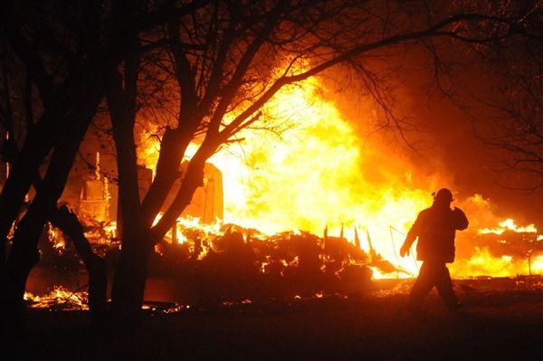
© Bryan Horwath/The Dickinson Press/APA firefighter examines the flames as a fire sweeps through Bucyrus, N.D., on Wednesday night
When a grassfire destroyed most of tiny Bucyrus, N.D., this week, the "perfect firestorm" of conditions served as a reminder that the long-term drought, combined with unpredictable winds, makes for severe fire danger across the central U.S., even in the middle of autumn.

Four homes and 20 other structures were lost after the fire broke out Wednesday afternoon. Fanned by winds up to 70 mph, it consumed at least 6,000 acres and traveled 10 miles by Thursday morning, The Dickinson Press reported.

"This is like a nightmare," Linda Wiskus told The Dickinson Press. "I wouldn't wish this on anyone. ... We had about 15 minutes to get what we could. I grabbed a safe, a pair of jeans and some socks - I didn't have time to get anything else."

The cause of the fire has yet to be determined, but Bucyrus is in a county that's been in continued drought since October 2011, Adnan Akyuz, North Dakota's state climatologist, told NBC News. Conditions got even worse starting Oct. 2.

"When you combine warm, dry and windy conditions, it creates a perfect setting for elevated fire danger," Akyuz noted. Adding drought to that mix, he said, "makes it more dangerous conditions for fire."

Blackbox

Wavering El Niño complicates NOAA's winter forecast

NOAA Press Release: Elusive El Niño challenges NOAA's 2012 U.S. Winter Outlook

The western half of the continental U.S. and central and northern Alaska could be in for a warmer-than-average winter, while most of Florida might be colder-than-normal December through February, according to NOAA's annual Winter Outlook announced today from the agency's new Center for Weather and Climate Prediction in College Park, Md.

Forecasters with NOAA's Climate Prediction Center say a wavering El Niño, expected to have developed by now, makes this year's winter outlook less certain than previous years.

"This is one of the most challenging outlooks we've produced in recent years because El Niño decided not to show up as expected," said Mike Halpert, deputy director of NOAA's Climate Prediction Center. "In fact, it stalled out last month, leaving neutral conditions in place in the tropical Pacific."

When El Niño is present, warmer ocean water in the equatorial Pacific shifts the patterns of tropical rainfall that in turn influence the strength and position of the jetstream and storms over the Pacific Ocean and United States. This climate pattern gives seasonal forecasters confidence in how the U.S. winter will unfold. An El Niño watch remains in effect because there's still a window for it to emerge.

Snowflake Cold

Global warming, where are you? Yet another paper demonstrates warmer temperatures 1000 years ago and even 2000 years ago

Yesterday I highlighted the paper "The extra-tropical Northern Hemisphere temperature in the last two millennia: reconstructions of low-frequency variability", by B Christiansen of the Danish Meteorological Institute and F C Ljungqvist of Stockholm University which showed that using a multitude of proxy samples in the norther hemisphere, that:
"The level of warmth during the peak of the MWP (Medieval Warm Period) in the second half of the 10th century, equaling or slightly exceeding the mid-20th century warming, is in agreement with the results from other more recent large-scale multi-proxy temperature reconstructions."
Now another paper, by Esper et al published in the Journal of Global and Planetary Change, shows that not only was the summers of the MWP equal or greater than our current warmth, but that the summers of the Roman Warm Period of 2000 years ago were significantly warmer than today.

old scandinavian temperatures
Fig. 4. Northern Scandinavian JJA temperatures back to 138 BC. The annually resolved N-Scan record (blue curve) shown together with 100-year filters of the reconstruction (red curve) and uncertainty estimates integrating standard and bootstrap errors (dashed curves). Light and dark grey bars indicate exceptionally warm and cold 30-year periods during the Roman, Migration, Medieval Warm, Little Ice Age, and Modern Warm Periods. Temperatures are expressed as anomalies with respect to the 1951–1980 mean.

Cloud Precipitation

UK's year of drought and flooding unprecedented, experts say

water ban
© AlamyBans on water use were put in place for large parts of England during spring 2012.
The scale of drought recovery in 2012 has 'not been seen before', says Centre for Ecology & Hydrology

The dramatic switch from drought and hosepipe bans in England this spring to the wettest April to June ever and widespread flooding was of a magnitude never seen before, water experts said on Thursday.

While water supplies have made "dramatic" recoveries from droughts before, such as in 1975-76, "sustained recoveries of this magnitude during the late spring and summer have not been seen before," said Terry Marsh, from the Centre for Ecology & Hydrology (CEH).

Earlier this month, the CEH said that following the wet summer, groundwater levels were above and "well above" the average for early autumn.

The Environment Agency (EA), which is responsible for drought measures and flood defences, said the extreme weather showed the need for the UK to adopt greater resilience to protect homes, roads and power stations.

Cloud Lightning

Blustery storm system sweeps through Arkansas and Mississippi - Tornadoes leave thousands without power


Thousands were left without power after a blustery storm system swept through Arkansas and Mississippi on Wednesday night, with initial reports saying it spawned at least five tornadoes.

Five people near Anguilla, Miss., were injured after their mobile home was completely destroyed, NBC station WLBT in Jackson, Miss., reported. A mother and her four children were inside the home, one child having received what appeared to be serious injuries, Sheriff Lindsey Adams told WLBT. The family was taken to a local hospital.

Not far from the scene, another mobile home was blown off its foundation and into a field. A woman was found inside and taken to a hospital with numerous injuries, WLBT reported.

In Conehatta, Miss., a suspected tornado downed dozens of trees and power lines, and damaged several structures, the Storm Prediction Center reported.

Cloud Grey

Powerful winds leave thousands without power in Denver area

It could be midday Thursday before electricity is restored to everyone who lost power in the Denver area after powerful winds. Xcel Energy Inc. says the blackouts affected about 50,000 customers in Denver, Fort Collins and Greeley starting at 10 p.m. Tuesday. Crews restored service to most by midday Wednesday.

About 5,500 were still without power Wednesday evening, and the company said it could be noon Thursday everyone's service is restored. The National Weather Service said gusts of up to 60 mph were reported in the Denver area and the northeast Colorado plains Tuesday night.

Gusts of 46 mph were reported in the northern Colorado town of Loveland on Wednesday. Fort Morgan, Akron and Holyoke in northeastern Colorado reported 40 mph gusts. The Weather Service issued a high wind warning for much of northeastern Colorado, with sustained winds of up to 40 mph and gusts of up to 60 mph possible.

Bizarro Earth

Kilauea Volcano lava lake reaches highest level


Bizarro Earth

Rail line closed for second time as floods hit Cumbria

Image
© Stephen MiltonThe centre of Whitehaven has been among the worst affected areas
Heavy rain has caused a landslip on a stretch of rail line in west Cumbria where a train was derailed six weeks ago. Services were halted after part of an embankment collapsed on to the Sellafield to Whitehaven line near St Bees. No-one was hurt. Concrete barriers put in place after a similar incident in August failed to prevent the line being damaged.

Elsewhere, Whitehaven and Egremont are among areas to have suffered flooding. Network Rail said buses were being used for passengers travelling between Sellafield and Whitehaven, with the line expected to remain closed until Thursday. Spokesman Keith Lumley said: "Unfortunately we're in exactly the same situation as we were last time.

"The earth has slid down from the top of the embankment, the majority of which has been caught by concrete barriers we put in after the last slip.

Bizarro Earth

Commuter hell as flood chaos sweeps Dublin, Cork

Image
Chaos reigned this morning after the country downpours and high winds lashed overnight. Torrential rain and high winds caused havoc in Dublin and Cork -- but conditions were expected to improve by this evening. Heavy rain from around 3am was too much for the drainage systems to cope with, causing water to build up on several major roads, particularly in south and west Dublin.

And it was a similar story in Cork this morning where city streets were under as much as two-feet of water as high tide blighted the city.

Impassable

In Dublin, AA Roadwatch reported serious flooding around the Tallaght area, with the road impassable at the Jobstown Inn, and from the Old Bawn junction on the N81 Tallaght Bypass down to the M50 junction.

Several cars stalled on the N81 after driving through flooded areas. Traffic in the area was heavy inbound during morning rush hour as motorists queued to try to negotiate the floods by driving one-by-one on the higher footpaths beside the affected roads.

Further west on the N81 there was heavy flooding from Brittas to Tallaght.