Earth ChangesS

Arrow Down

2 Great Lakes hit lowest water level on record


Two of the Great Lakes have hit their lowest water levels ever recorded, the U.S. Army Corps of Engineers said Tuesday, capping more than a decade of below-normal rain and snowfall and higher temperatures that boost evaporation.


Measurements taken last month show Lake Huron and Lake Michigan have reached their lowest ebb since record keeping began in 1918, and the lakes could set additional records over the next few months, the corps said. The lakes were 29 inches below their long-term average and had declined 17 inches since January 2012.

The other Great Lakes - Superior, Erie and Ontario - were also well below average.

"We're in an extreme situation," said Keith Kompoltowicz, watershed hydrology chief for the corps district office in Detroit.

The low water has caused heavy economic losses by forcing cargo ships to carry lighter loads, leaving boat docks high and dry, and damaging fish-spawning areas. And vegetation has sprung up in newly exposed shoreline bottomlands, a turnoff for hotel customers who prefer sandy beaches.

Snowflake Cold

Southern Ontario braces for biggest snowstorm in years

Image
© CBC News
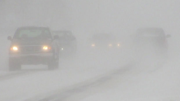
The Friday morning commute is looking to be an ugly one for Southern Ontario as the Alberta Clipper swinging through the area today is amplified by moisture from another storm system moving up from the United States.

"It might be the biggest storm since 2011," said Rob Khun, a severe weather meteorologist with Environment Canada, referring to the March 2011 storm that dumped 12.5 cm of snow on the GTA.

Snow from the storm system has begun to fall in southwestern Ontario this morning as the Alberta Clipper tracks through the area, and it should arrive in the GTA by this afternoon. This will leave about 2 cm of accumulation on the ground, however the added moisture arriving from the south this evening will turn this to heavy snowfall overnight and into Friday morning.

Total accumulations for southern Ontario are expected to be between 15 and 25 cm of snow, and strong winds will add blowing snow to the mix, making for hazardous driving conditions tonight, through the Friday morning commute, and possibly into tomorrow afternoon as well.

Eastern Ontario is expected to be even harder hit, as snowfall accumulations already forecast to be up to 25 cm from the Alberta Clipper are pushed up to 35 cm or higher by the approaching storm from the south and local amplification due to winds blowing in off of Lake Ontario.

Environment Canada has issued Snowfall Warnings from London-Essex to Kingston-Prince Edward regions, and from Niagara region up into Grey-Bruce along the shores of Lake Huron and Georgian Bay.
Snowflake

Monster blizzard Nemo headed for U.S. Northeast

Blizzard_1
© Kelly Keene
A significant snowstorm is expected, which can be compared to the 1978 blizzard. Snowfall could exceed two feet (.6 meters) in some areas.

The northeastern United States is preparing for a monster storm, which many are calling Nemo, expected on February 8, 2013. It could easily produce over two feet of snow (.6 meters) and wind gusts over 60 miles (96 km) per hour, causing zero visibility and bringing cities to a standstill.

In many ways, we are looking at an historic storm that could paralyze cities such as Boston, Providence, and Hartford. We're expecting blizzard conditions in eastern and southeastern Massachusetts, Connecticut, Rhode Island, Northeastern New Jersey, Long Island, southeastern Maine, and New York City.

Moderate to major coastal flooding is also possible. Two storm systems will phase together to create a large pressure gradient that will result in winds sustaining around 35-50 mph with gusts over 74 mph. Tonight is the last night to get ready for a significant snowstorm that can be compared to the 1978 blizzard.
Blizzard
© Google/NWSBlizzard warnings are in effect for parts of the Northeast.

Sun

Crepuscular rays over the Gulf of Mexico

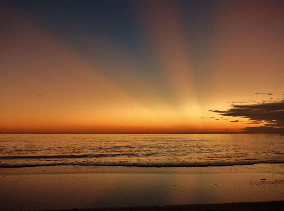
Our friend on Facebook, Rick Trommater in St. Peterburg, Florida, captured this beautiful photo of crepuscular rays at sunset on the evening of February 5, 2013.
Crepuscular Rays
© Rick Trommater/EarthSky OrgCrepuscular rays, sometimes called sunrays, via Rick Trommater. View Larger
Crepuscular rays are columns of sunlit air, streaming through gaps in clouds or other objects (for example, mountain peaks). Darker cloud-shadowed regions lie between the sunlit columns.

These rays are really parallel to each other. But they appear to diverge, much as a road that looks narrow in the distance appears wide beneath your feet. This beautiful photo of a winter sunset over the Gulf of Mexico shows them clearly.

Bizarro Earth

More volcanic activity in Solomons quake zone

The National Disaster Management Office in Solomon Islands says volcanic activity has increased on an island in Temotu province since the magnitude 8.0 earthquake two days ago.

Sipuru Rove says the uninhabited island of Tinakula, which is about 50 kilometres north of Lata, has being making loud and strange sounds.

He says help and information is needed from technical experts to assess the risk posed to the local community by the volcano as they are worried an eruption could be near.
"The volcanic activity on one of the islands that is off Lata is alarming at the moment. And this will really require scientific special people to assist us in assessing this volcanic activity which is beginning to be abnormal."
Sipuru Rove says there are also significant aftershocks which meant a plane with supplies and medical staff couldn't land and was forced to return to Honiara.

Bizarro Earth

Researcher discovers future megavolcano

Megavolcano
© Fox13 News
Salt Lake City - A researcher at the University of Utah is making waves in the scientific community with a discovery deep within the Earth that could cause extinction.

Michael Thorne, a seismologist and assistant professor at the University of Utah, has discovered a dark red blob in the Earth's core that could prove devastating.

Research shows that two rock piles the size of continents are colliding, creating a molten rock the size of Florida that could eventually cause a giant eruption.

"Something like the size of Alaska eruption probably coming out in the Pacific Ocean. This is something that might be down the road some 100 million years or so," Thorne said. "This is the kind of eruption that would make a super volcano eruption look pretty small."

Snowflake

New England blizzard - one for the books? Major winter storm on its way

New England blizzard: Forecasters are predicting more than 2 feet of snow in New England, and blizzard conditions, including high winds, blowing snow, and coastal flooding. A major winter storm heading toward New England may not be one for the record books, but even some of the nation's snow-hardiest people should proceed with caution, according to at least one expert.
Image
The National Weather Service forecasts blizzard conditions in New England by late Friday afternoon.
As much as 2 feet of snow could fall on a region that has seen mostly bare ground this winter, the National Weather Service said. That's exciting for resort operators who haven't had much snow this year.

The storm would hit just after the 35th anniversary of the historic blizzard of 1978, which paralyzed the region with more than 2 feet of snow and hurricane force winds from Feb. 5-7.

"This has the potential for being a dangerous storm, especially for Massachusetts into northeast Connecticut and up into Maine," said Louis Uccellini, director of the weather agency's National Centers for Environmental Prediction.

Bizarro Earth

Dome grows in Alaska's Cleveland Volcano

Cleveland Volcano
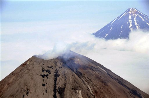
© AP Photo/NOAA, Kym YanoThis Monday, Aug. 8, 2011 file aerial photo provided by the National Oceanic and Atmospheric Administration shows Cleveland Volcano, left, located in the Aleutian Islands 939 miles southwest of Anchorage, Alaska. The volcano, which has sent up major ash eruptions in the past, is heating up near its summit. Scientists at the Alaska Volcano Observatory say satellite data obtained a week ago indicates a lava dome is growing in the summit crater. The observatory has changed its alert level for aircraft.
Anchorage, Alaska - Alaska's Cleveland Volcano is heating up and scientists are on alert in case it sends up an ash cloud that could threaten trans-Pacific flights.

The Alaska Volcano Observatory detected elevated surface temperatures Jan. 24 at Cleveland's summit. Satellite data obtained last week indicated that a growing lava dome on the floor of the summit crater had reached about 328 feet, or 100 meters, in diameter.

The summit crater itself is nearly 10 times that size, said Chris Waythomas of the U.S. Geological Survey.

"It does this from time to time and it's a fairly small lava dome," he said Wednesday. "It's not gigantic."

Lava domes form a lid on a volcano chamber that holds magma. When they grow big enough, lava domes can become unstable and collapse. Decompression of the magma chamber can lead to an explosion as the conduit inside the volcano suddenly becomes unsealed and gasses escape.

Bizarro Earth

What caused the Solomon Islands earthquake & tsunami?

Solomon Quake
© U.S. Geological SurveyA map showing the intensity of shaking caused by a magnitude 8.0 earthquake in the Solomon Islands.
The deadly earthquake and tsunami that hit the Solomon Islands today struck along a subduction zone, the same geologic setting responsible for the world's most powerful earthquakes.

In a subduction zone, two of Earth's tectonic plates meet and one slides beneath the other into the mantle, the deeper layer beneath the crust. The Solomon Islands sit above the collision between the Australia and Pacific plates. In the region of today's magnitude-8.0 earthquake, the Australia plates dives beneath the Pacific plate toward the east-northeast at a geologically speedy 3.7 inches (94 millimeters) per year, according to the Incorporated Research Institutions for Seismology (IRIS).

The earthquake hit at a depth of 17.8 miles (28.7 kilometers) and was the second-largest earthquake in the Solomon Islands region in almost 40 years, IRIS said in a statement. Several aftershocks followed; the largest measured magnitude 6.6, according to the U.S. Geological Survey (USGS).

The tsunami generated by the quake, reported as 3 feet (0.9 meters) in height, hit villages on Santa Cruz Island, destroying structures and homes, according to news reports. A tsunami watch was issued for Australia, Indonesia and New Zealand, but not for the rest of the Pacific, according to the West Coast and Alaska Tsunami Warning Center.

Bizarro Earth

USGS: Earthquake Magnitude 7.0 - 27km NNW of Lata, Solomon Islands

Image
© USGS
Event Time:
2013-02-06 01:54:15 UTC
2013-02-06 12:54:15 UTC+11:00 at epicenter

Location:
10.479ยฐS 165.772ยฐE depth=9.8km (6.1mi)

Nearby Cities:
27km (17mi) NNW of Lata, Solomon Islands
579km (360mi) NNW of Luganville, Vanuatu
648km (403mi) E of Honiara, Solomon Islands
848km (527mi) NNW of Port-Vila, Vanuatu
1166km (725mi) N of We, New Caledonia