Earth ChangesS


Cloud Lightning

Floods hit Pakistan again

Image
Punjab and Khyber Pakhtunkhwa are facing flood threat as the Met Office has forecast heavy rains in the next two days.

There was a low-level flood in River Ravi at Baloki but the water level was gradually increasing.

According to Indus River System Authority (IRSA), in River Indus the water inflow at Tarbela was 256,000 cusecs and outflow was 140,000 cusecs, while in River Jhelum at Mangla the water inflow was 63,000 cusecs and outflow was 13,000 cusecs.

In River Chenab, the inflow was 126,800 cusecs and outflow was 91,800 cusecs at Marala. Water inflow recorded in

River Sutlej near Head Sulemanki was 16,777 cusecs and outflow remained 4,792 cusecs.

According to the Meteorological Department, the three rivers of Punjab, Ravi, Chenab and Jhelum, were facing flood threat. The department also forecast that within next 48 hours scattered rain/thundershower was expected over Azad Kashmir, Hazara, Islamabad/Rawalpindi, Lahore and Gujranwala divisions. The department predicted hot and humid weather elsewhere in the country.

Life Preserver

Tropical storm Isaac destroys tent camps for Haiti's homeless

Thousands of Haitians made homeless by a devastating earthquake two years ago are affected by tropical storm Isaac, as torrential rain and winds destroy the tent camps they live in. Because the country is heavily deforested, there are immediate concerns Isaac could trigger deadly flash flooding and mudslides.


Source: Reuters

Cloud Lightning

Myanmar flooding forces 85,000 to flee homes

Image
Heavy flooding has displaced at least 85,000 people in Myanmar.
The Myanmar government says at least 85,000 people have been driven from their homes by heavy flooding.

According to government relief officials, the people fled their homes on Saturday, following the worst monsoon flooding in years, which covered about 250,000 hectares of rice fields.

The Irrawaddy Delta, which was devastated in 2008 by Cyclone Nargis, was reported the worst hit area.

Cyclone Nargis killed about 130,000 people in the delta in 2008.

Heavy rains over the past few weeks have been the reason for the flooding, which initially hit the southern delta region.

Arrow Up

Ecuador on Alert Over Spewing Tungurahua Volcano

Image
© @IGecuador, Instituto Geofísico Tungurahua Volcano, August 12, 2012
The Tungurahua volcano, an icon and symbol of sovereignty for Ecuadorians, has been registering new activity since the night of August 12, 2012, when incandescence was spotted around the crater zone, as reported by the Geophysical Institute EPN (Polytechnic National School) [es].

The volcano has been spewing pyroclastic material and ash throughout this month, affecting 3,072 families, 4,329 acres of pasture and crops, and 5,700 animals, according to Ministry of Agriculture [es] officials at the time of writing this post.

The "Report on recent activity in the Tungurahua volcano", published on August 14 on the Geophysical Institute's official website, reported that the volcano's activity had remained "at a moderate to low level." However, on Sunday, August 5, two moderate explosions were registered, and from then on greater activity has been recorded during the rest of the month.

Pi

Scientists theorise that scale of Japanese tsunami due to collapse of sea bed

Image
© Rémi Maynègre, cafoutche.blogspot.fr
Scientists at Cambridge University have developed a model that may show why some tsunamis - including the one that devastated Japan in March 2011 are so much larger than expected. The Japanese tsunami baffled the world's experts as it was far bigger than might have been anticipated from what is known about the deep sea earthquakes that create long waves out in the ocean.

In a paper published today (24 August 2012) in the journal Earth and Planetary Science Letters, Professors Dan McKenzie and James Jackson of Cambridge's Department of Earth Sciences describe for the first time the added factor that may have made this tsunami so severe: a huge collapse of soft material on the sea bed resulted in a far greater movement of water than would have been caused by the earthquake alone.

Tsunamis occur when an earthquake rapidly changes the shape of the sea floor, displacing the water above it. The earthquake itself is the abrupt rupture of a fault surface separating rocks that have steadily been bending like a loaded spring, before suddenly overcoming friction and slipping, releasing the elastic energy. In the case of the Japan earthquake, the fault is the plate boundary, allowing the Pacific sea floor to slide beneath Japan. The wave formed at the sea surface as the sea floor moves can cause untold damage when it hits shore.

Bizarro Earth

Sinkhole engineer: Little can be done if cavern is fractured

GOHSEP
© GOHSEPGOHSEP Bayou Corne Status Update shocks 350 evacuees and others at public meeting, 24 August

If the sinkhole cavern is fractured, little can be done was the news approximately 350 residents heard at a public meeting Friday night in Pierre Part about recent developments of the pending oil and gas-related catastrophe.

"If it's a cavern fracture, failure, whatever, there's little that you can do," Department of Natural Resources' (DNR) civil engineer who is coordinating the science group studying the sinkhole, Chris Knotts told the crowd at the public meeting Friday night in Pierre Part, Louisiana.

A "low but audible rumble in the crowd" followed that statement by Knotts, according to David Mitchell, reporting for The Advocate.

"If it's as simple as a casing, yes (it can be fixed)," Knotts said.

Several agencies provided a sinkhole disaster overview Friday for approximately 350 people at St. Joseph the Worker Catholic Church's parish hall in Pierre Part. They addressed recent sinkhole developments and the continuing natural gas releases preceding the sinkhole by about two months and the ongoing gas being released.

Attention

Strange Sounds in the Sky, Manchester, UK - August 22nd 2012

My only guess is that I'm hearing echos from far away industrial plants/factories/ship yards... the sound must be traveling on the wind?


Comment: Not likely because something similar was heard elsewhere in England the following day:

Strange Sounds in the Sky, Halton, UK - August 23rd 2012


Attention

Strange Sounds in the Sky, Halton, UK - August 23rd 2012

During a recording session we heard strange sounds outside and grabbed the camera to see if we could record them. We managed to catch the last three bursts and then it all fell silent. These sounds fascinate us and would love to hear from others who have heard similar sounds. We are near ICI so it could be them but I've never heard anything like this before in all my time living here.


Comment:


Umbrella

South Florida on alert as Tropical Storm Isaac exits Haiti, killing 3


At least three people died in Haiti as Tropical Storm Isaac triggered mudslides and flooding there before heading back over water and towards Cuba. Isaac should become a Category 1 hurricane on Sunday just as it nears the Florida Keys, the U.S. National Hurricane Center said, and then grow into an even stronger Category 2 storm.

"Hurricane conditions are expected in the hurricane warning area in southwest Florida and the Florida Keys on Sunday," the center said in a Saturday morning advisory.

The center now expects Isaac to build to a Category 2 hurricane, with winds up to 110 mph, after it enters the warmer waters of the Gulf of Mexico.

In Haiti, a woman and a child in the town of Souvenance were killed in the storm, a local official reported.

In the capital Port-au-Prince -- where some 350,000 people are still living in tents or shelters after the 2010 Haiti earthquake -- a girl, 10, was killed when a wall fell on her.

Cloud Lightning

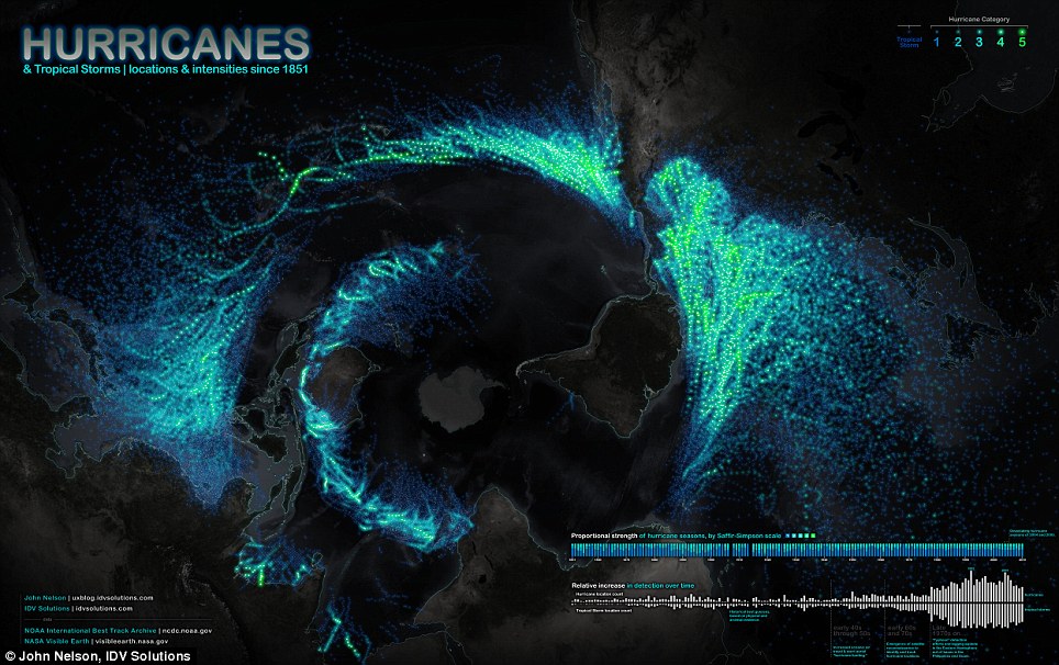
Recent increase in number of hurricanes and tropical storms shown on amazing infographic of all storms recorded globally since 1851

It is an astonishing view of the swirling paths hurricanes and tropical storms have taken across the globe.

This amazing image was created by designer John Nelson, and shows data of every recorded event since 1851.

It also offers a unique perspective of the earth from the bottom up - with Antarctica in the middle, the Americas on the right and Asia on the left
Image
© John Nelson, IDV SolutionsAn astonishing new map reveals all of the world's hurricanes and intense weather events since 1951 in a single image.
Mapmaker Nelson, the user experience and mapping manager for IDV Solutions, a data visualization company, claims the unique view was the best way to tell the story of the data.

'When I put it onto a rectangular map it was neat looking, but a little bit disappointing,' Nelson told OurAmazingPlanet.

But the unorthodox, bottom-up perspective allowed the curving paths the storms make across the world's oceans to shine, he said.

Comment: Go here to see John Nelson's hurricane and tropical storms map in close-up detail.