04 APRIL 2018
Mississippi River flooding worse now than any time in past 500 years Efforts to control the river's flow with levees and other structures have increased the risk of dangerous floods.
Floods on the mighty Mississippi River are larger and more frequent today than at any time in the past 500 years - in part, a new study suggests, because structures erected to control the river have increased the flood risk.
[...]
The US Army Corps of Engineers, the government agency that manages the river flow, declined to comment on the study. But Robert Twilley, a coastal-systems ecologist who directs the Louisiana Sea Grant College Program at Louisiana State University in Baton Rouge, says that the study "should be on every desk of every Corps engineer who is designing infrastructure for the Mississippi River".
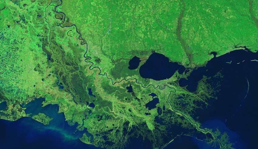
To reconstruct the river's history, Samuel Munoz, a geoscientist at the Woods Hole Oceanographic Institution in Massachusetts, and his colleagues looked at oxbow lakes and oak trees on the lower Mississippi between southern Missouri and Louisiana. Oxbow lakes are coils of river that became detached from the main flow as the Mississippi changed course.
[...]Humans build things in floodplains and try to control nature... And we wonder what could possibly go wrong... Kind of like building expensive resorts and beach houses in places frequented by hurricanes. However, it seems like something is missing from this article... What's missing? No mention of fossil fuels, heat-trapping greenhouse gases or anthropogenic climate change!
The result surprised Munoz. Both the frequency and magnitude of floods on the Mississippi have increased in the past 150 years. Floods were correlated with global weather patterns linked to the El Niño-Southern Oscillation in the Pacific Ocean and the Atlantic Multidecadal Oscillation, both of which influenced when and how much rain entered the system. But these climate cycles couldn't explain all of the increase.
Human influence
Munoz and his team suggest that up to three-quarters of the increased flood risk might be attributable to the dams, walls and levees that now confine the river.
[...]
Nature
The worst flooding in 500 years isn't being attributed to Gorebal Warming! Shocking? Not really. Mississippi megafloods aren't unprecedented.
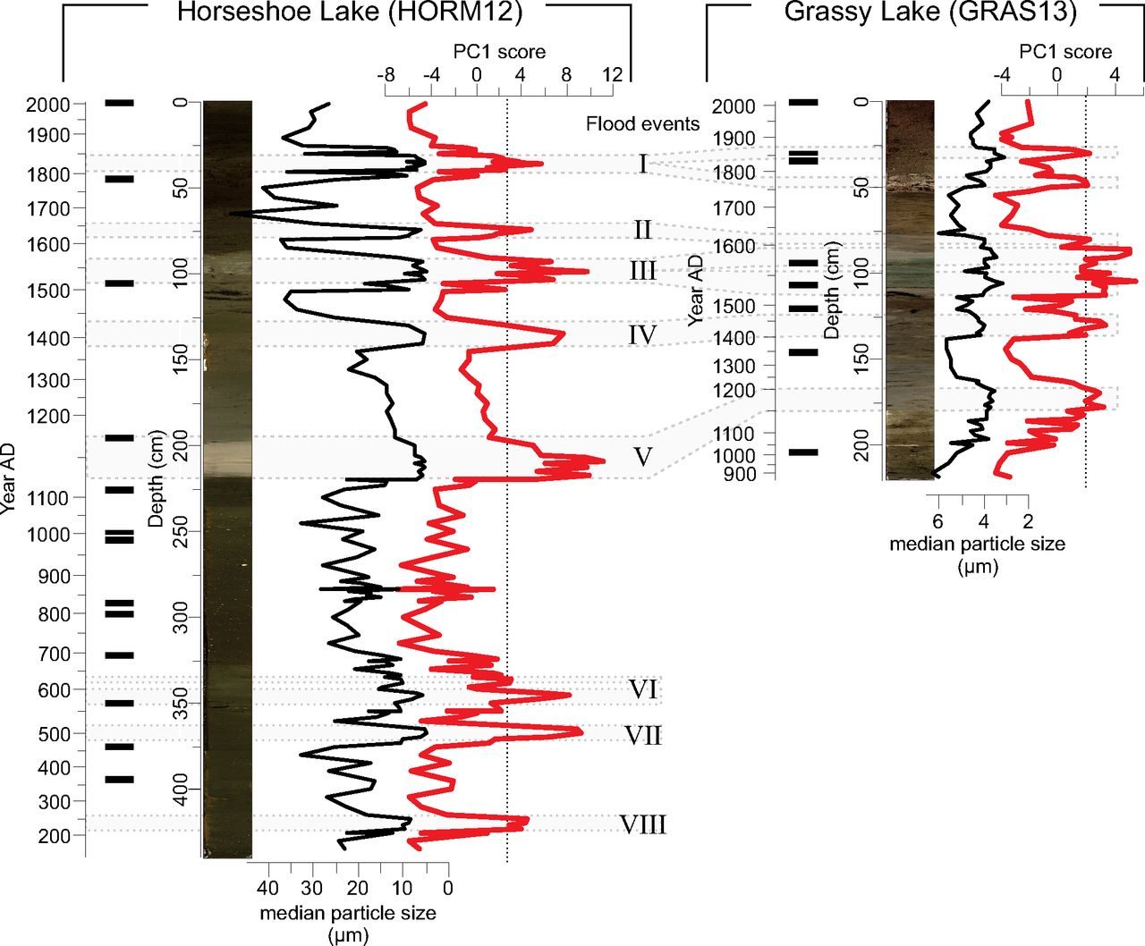
There were at least 8 Mississippi River megafloods between 200 and 2000 AD. If the flooding is worse today than at any time in the past 500 years, it currently ranks between flooding events II and III.Cahokia's emergence and decline coincided with shifts of flood frequency on the Mississippi River
Samuel E. Munoz, Kristine E. Gruley, Ashtin Massie, David A. Fike, Sissel Schroeder and John W. Williams
PNAS May 19, 2015. 112 (20) 6319-6324; published ahead of print May 4, 2015. https://doi.org/10.1073/pnas.1501904112
Edited by James A. Brown, Northwestern University, Evanston, IL, and approved April 8, 2015 (received for review January 28, 2015)
Significance
Our paper evaluates the role that flooding played in the emergence and decline of Cahokia-the largest prehistoric settlement in the Americas north of Mexico that emerged in the floodplain of the Mississippi River around A.D. 1050. We use sediment cores to examine the timing of major Mississippi River floods over the last 1,800 y. These data show that Cahokia emerged during a period of reduced megaflood frequency associated with heightened aridity across midcontinental North America, and that its decline and abandonment followed the return of large floods. We conclude that shifts in flood frequency and magnitude facilitated both the formation and the breakdown of Cahokia and may be important factors in the declines of other early agricultural societies.
Abstract
Here we establish the timing of major flood events of the central Mississippi River over the last 1,800 y, using floodwater sediments deposited in two floodplain lakes. Shifts in the frequency of high-magnitude floods are mediated by moisture availability over midcontinental North America and correspond to the emergence and decline of Cahokia-a major late prehistoric settlement in the Mississippi River floodplain. The absence of large floods from A.D. 600 to A.D. 1200 facilitated agricultural intensification, population growth, and settlement expansion across the floodplain that are associated with the emergence of Cahokia as a regional center around A.D. 1050. The return of large floods after A.D. 1200, driven by waning midcontinental aridity, marks the onset of sociopolitical reorganization and depopulation that culminate in the abandonment of Cahokia and the surrounding region by A.D. 1350. Shifts in the frequency and magnitude of flooding may be an underappreciated but critical factor in the formation and dissolution of social complexity in early agricultural societies.
[...]
Full Text Available, PNAS

The megaflood hiatus ran from roughly the nadir of the Migration Period Cooling to the peak of the Medieval Warm Period. The megaflood frequency abruptly increased near the onset of the Little Ice Age:

While our dams, levees and other flood-control structures may have ironically contributed to the worst Mississippi River flooding in 500 years, they had nothing to do with the previous eight megafloods.
Comment: Mississippi floods are the biggest in 500 years - and human intervention may be partly to blame
Speaking of megafloods that humans didn't cause... Have you ever heard of the Zanclean megaflood? It was triggered by the Messinian salinity crisis (MSC). It was a doozy. If Gavin Schmidt's Silurian civilization had been thriving on the Messinian salt flats during the Late Miocene, the Zanclean megaflood would have wiped them out without a trace. The transition from the MSC to the Zanclean megaflood marks the transition from the Miocene to the Pliocene. It left a serious mark on the stratigraphic record.
Some reconstructions of Zanclean megaflood suggest that sea level in the Mediterranean could have risen at a rate of 10 meters per day during the peak flow of water from the Atlantic into the Mediterranean basin.
A Megaflood-Powered Mile-High Waterfall Refilled the Mediterranean
Evidence of the Zanclean megaflood in the eastern Mediterranean Basin
Catastrophic Flood of the Mediterranean After the Messinian Salinity Crisis


Reader Comments
to our Newsletter