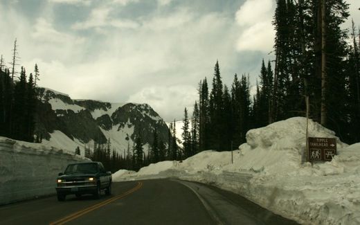
Half of the record snowpack in the upper basin of the Colorado and Wyoming mountains has melted and flowed into Seminoe Reservoir, said John Lawson, the U.S. Bureau of Reclamation's manager for the Wyoming area.
Seminoe is the first of seven bureau reservoirs that capture and store runoff from the mountains, mainly for irrigation. That water eventually flows into Nebraska, via the North Platte River, and is stored at Lake McConaughy near Ogallala.
Lawson said the snowpack hasn't been this heavy since 1909 and 1917. The bureau believes this year's runoff will match or exceed those two years, Lawson said.
As of Thursday, Seminoe Reservoir had received 1,007,000 acre feet.
An acre-foot is the amount of water it takes to cover an acre to a depth of one foot.
Lawson said he feels no sense of relief that half of the snowpack is gone from the mountains.
"We're dealing with estimated flows and snowpack that we don't have any historical information on."
Lawson said composite measurements taken of the snowpack at various sites in the upper basin of southern Wyoming on Friday showed the snowpack to be 376 percent of average.
"We have no recorded information of having a record snowpack like this year," said Lawson in a phone interview from his office in Mills, Wyo.
Although the numbers are dramatic, Lawson said the bureau is "not too interested" in snowpack percentages; what matters is how much water that snowpack holds.
This year, the bureau estimates the water content will be 42 inches, Lawson said. The previous record was 33 inches, set in 1983.
About 80 percent of the runoff occurs between April and July, Lawson said.
"A lot of it is in transit," Lawson said. "And lots of it is still there."
In February, snowpack measurements in the mountains were at 139 percent of average and the bureau reacted quickly, Lawson said.
"We made the decision then -- we needed to start moving water out of the system," he said. "You can't wait in this business. If you procrastinate, you're in big trouble."
Lawson said the bureau has released more water since March 1 than at any other time in its 60-year history.
The water releases have caused flooding downstream from Lake McConaughy, especially near North Platte, where there were several minor levee breaches earlier this month.
Lawson said the early releases created about 40 percent more storage capacity in Seminoe Reservoir, and that helped reduce flows into Nebraska.
The bureau's biggest fear is heavy rainfall.
Heavy rain "would change the forecast (for runoff) dramatically."
The situation on the North Platte River appears to be improving for now.
On Friday, the Central Nebraska Public Power and Irrigation District said it was reducing outflows from Lake McConaughy from 5,000 cubic feet per second to 4,500 cfs.
Central spokesman Tim Anderson said the Holdrege-based district cautioned that the melting of the snowpack which feeds water into the South Platte River has not happened yet, and that has officials worried about how much water will be flowing into Nebraska.
Lawson said snowpack conditions for the South Platte River are similar to those on the North Platte River.
Meanwhile, irrigation season started last week, and that should help reduce water levels near the city of North Platte, Anderson said.
"It could have been a lot worse if Lake McConaughy had not been there to take the pressure off of it," he said.


Reader Comments
to our Newsletter