Storms
S


Cloud Lightning

Baseball-sized hail, heavy rain and tornadoes pound the Midwest and Southern U.S. states

Image
Thunderstorms were crawling across a large swath of the Midwest and South on Thursday, spawning suspected tornadoes in Missouri and Texas, and slamming several states with large hail and heavy rain that prompted a handful of water rescues.

Four people were injured in Texas when a suspected tornado destroyed a farmhouse and a mobile home Thursday night near Merit, about 40 miles northeast of Dallas. Hunt County Sheriff Randy Meeks said the injuries weren't life-threatening, though he didn't have details.

Storms pummeled the North Texas college city of Denton with hail as large as baseballs, leading to reports of broken windows and other damage. The National Weather Service in Tulsa noted reports of hail up to the size of ping pong balls and strong wind gusts.

Image

Windsock

Tornadoes in the forecast for Midwest U.S.

Image
© Farmers' Almanac
A large swath of the U.S. Midwest is bracing for potentially dangerous weather including possible tornadoes as an intense storm system moves through the region on Wednesday and Thursday, according to the National Weather Service.

The area of greatest risk includes Oklahoma, Arkansas, southern Missouri and Illinois and western Kentucky and Tennessee, where significant tornadoes, large hail and damaging winds could strike Thursday afternoon and evening, said John Hart, a meteorologist in the service's storm prediction center.

"The parameters look pretty good for tornadic storms tomorrow, but the models are varying quite a bit on where the corridor of greatest risk will be," Hart said.

Snowflake Cold

April snowstorm in Minnesota could be record breaking

Image
© AP/Paul Sancya
Prince was wrong. It's not "Sometimes It Snows In April." It's "Always It Snows In April."

OK, it only seems that way after the brutal winter we had this year, and the extended winter we had last year. But many Minnesotans are understandably at the breaking point with the news that a spring snowstorm is expected to dump possibly more than a foot of snow in many parts of the state.

The National Weather Service has issued winter storm warnings for most of the state, including the Twin Cities. The warning is in effect from Thursday afternoon until Friday night.

WCCO director of meteorology Mike Augustyniak says that the storm should begin with a wintry mix in the Twin Cities. Then it will eventually begin to turn over into heavy, wet snow late Thursday into Friday morning. The period of accumulating snow could last up to 12 hours, Augustyniak said.

Cloud Lightning

Giant hailstones batter Hong Kong as observatory warns of further heavy rain

Image
© SCMP Pictures 'freak' giant hailstones - which are becoming more common. A 'sign of the times'?
Amber Rainstorm warning raised as people warned 'be alert'

Hong Kong was today warned to brace for more bad weather after giant hailstones last night pounded parts of the city and the Black Rainstorm signal was issued for the second time since 2010.

At 8.40am this morning the Amber Rainstorm warning was issued, with more than 30 millimetres of rain falling in just an hour, disrupting rush hour and making journeys to work difficult. The signal was cancelled at 11.40am.

As of 11am, 200 flights had been delayed, 44 cancelled and one diverted, the Airport Authority said.

The Hospital Authority confirmed that there were seven people admitted to accident and emergency departments of public hospitals during the Black Rainstorm signal raised between 8.40pm and 10.30pm on Sunday night. Of the seven casualties, ranging in age from a one-year-old to a 64-year-old, six were in stable condition and one was in serious condition.

A spokesman could only confirm that the patient in serious condition was a 29-year-old male and was currently at Princess Margaret Hospital.


Cloud Lightning

Severe thunderstorms from Dallas to St. Louis - hail, high winds, flash flooding, possible tornadoes

Image
Severe thunderstorms on Wednesday will threaten 18 million people from northern Texas to eastern Kansas, much of Missouri and southern Illinois. The threat on Wednesday includes the potential for a couple of strong tornadoes.

The severe weather on Wednesday is part of a multiple-day severe weather event that will continue through the end of the week and will reach parts of the Midwest, East and South.

Cities in the area of concern for dangerous and disruptive weather conditions Wednesday and Wednesday night include Dallas; Wichita, Kan.; Oklahoma City and Tulsa, Okla.; Little Rock and Fort Smith, Ark.; Kansas City, Springfield, Joplin and St. Louis, Mo.; Shreveport, La.; Memphis, Tenn.; Paducah, Ky.; Evansville, Ind.; and Mt. Vernon, Ill.

Cloud Lightning

Giant hailstorms and heavy rain kill at least 16 people in China

Image
Destruction: This factory workshop was completely destroyed when giant hailstones hit the area of Dongguan in southern China's Guangxi province
Heavy storms and giant hailstones have left at least 16 people dead and caused widespread property damage in southern China.

The poor weather has lasted more than a week, bringing landslides and flooding - particularly in the autonomous Guangxi province, which borders Vietnam.

Local authorities say at least 16 people have been killed, although that figure is likely to rise as the true extent of the devastation cannot be fully assessed until the poor weather subsides.

Yesterday the Civil Affairs Department of Guangxi said at least 70 houses had collapsed, with another 1,716 badly damaged, and more than 2,000 hectares of crops destroyed.

Local weather forecasts said heavy rain and hail is expected to continue to hit parts of Guangxi over the next few days, before subsiding in the latter half of this week.

Landslide and flood warnings are likely to remain in place well into next week.

Image
No protection: A roof in Dongguan is covered in holes after giant hailstones crashed through the ceiling

Cloud Lightning

Rare tornado damages dozens of homes in Roseville, California

Image

A rare tornado damaged dozens of homes in Northern California, sending roof tiles and solar panels flying.

Source: CBS News

Windsock

170km/h snowstorm blows two Canadian weathermen off their feet in Nova Scotia, not once but TWICE!

Image
Powerful: The men are being blown off camera by wind gusts that exceeded 100MPH

These two intrepid news reporters certainly earned their money this week.

This incredible video shows the moment severe snow storm conditions actually blew Mark Robinson and Chris Scott out of shot while doing pieces to camera.

Coincidentally the pair were explaining that the winds had got up to 170km/h when they knocked off their feet.

"The only storm I can compare this too is a hurricane," one can be heard saying.

"This has the added bonus of having the snow in the air... like standing in a sand blaster," they say before being literally blown away.

Unsurprisingly the clip has proved popular online with over 85,000 people tuning in less than a day.

Comment: Here's video footage from another location showing these two 'extreme weathermen' being blown over in this snow'icane:


Snowflake Cold

North America's brutal 2014 winter in one minute - watch time-lapse video

As spring arrives - albeit slowly - East Coasters are saying goodbye a to an especially punishing winter.

Those feeling sentimental can relive the endless series of snowstorms and fiendishly cold weather in a new time-lapse video from NASA.

The animation stiches together imagery taken from space by NOAA's GOES-East satellite every day from January 1 to March 24, 2014.


The creator, Dennis Chesters, of the NASA/NOAA GOES Project at the Goddard Space Flight Center in Greenbelt, Md., said in a statement: "The once-per-day imagery creates a stroboscopic slide show of persistent brutal winter weather."

And brutal it was. Cold air escaping the polar vortex repeatedly blasted Canada and the continental United States. Two inches of snow humbled Atlanta in late January, creating epic traffic jams stranding hundreds of people in their cars for hours. Ice storms that followed in February left thousands without power in Georgia and South Carolina. The Great Lakes' ice cover reached historic levels, growing to 91 percent in early March.

Major cities reported astounding tallies of winter snow. Residents of Washington, D.C. saw 30.3 inches (76.9 centimeters) of snow during the 2013-2014 season - nearly double the city's average snowfall of 15.3 inches (38.8 cm), according to the National Weather Service. A whopping 80 inches (203 cm) of snow fell on Chicago, far exceeding the typical 34.4 inches (87.3 cm).

The GOES-East satellite is perched in a geostationary orbit, meaning it hovers over the same part of the globe all the time, moving in tandem with Earth's rotation. The spacecraft captures images of the Northern Hemisphere every half hour and then takes a shot of the entire Western Hemisphere every three hours, according to NOAA.

The images of clouds taken by the GOES satellite are used by the National Weather Service to monitor storms. The 2014 winter weather video also incorporates true-color imagery of the land and sea obtained with NASA's Earth-watching NASA's Aqua and Terra satellites.

Snowflake

Powerful Spring blizzard cuts power to thousands in New England

Image
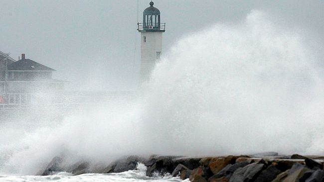
© AP/Michael DwyerWind-driven waves crash on a sea wall in Scituate, Mass., Wednesday, March 26, 2014. Cape Cod and the islands were expected to bear the brunt of the spring storm that struck full force Wednesday.
Mother Nature proceeds to show no mercy, as only a few days after the official start of spring, the East Coast was blasted with yet another major snowstorm.

Spanning from Virginia up through New England and parts of Atlantic Canada, the system brought snow to regions in Maryland and Washington, D.C., before heading up the coast and slamming Cape Cod, Mass., with blizzard conditions.

Grounding flights, causing traffic accidents and knocking out power to nearly 6,000 people throughout Massachusetts, the storm was accompanied by howling winds that gusted up to more than 80 mph in Nantucket.

The severity of the winds also generated dangerous travel conditions, as blowing and drifting snow whipped the island and surrounding areas.

As the storm moves out of the United States and into Atlantic Canada, the Maritimes and western Newfoundland, it will be accompanied by hurricane-force winds, producing treacherous travel conditions.

Comment:
STILL not done - Massive March Nor'easter bigger than Hurricane Sandy expected to bring winds, snow, cold blast to Northeast