Storms
S

Cloud Lightning

Indiana, US: Storms continue; floods forecast

The National Weather Service in northern Indiana has issued a number of flood watches and warnings for northeast Indiana and northwest Ohio.

The flood warning continues for the following rivers:
  • St. Joseph River affecting Allen and DeKalb counties in Indiana and Defiance County in Ohio until Friday night. At 1 p.m. Monday, the river was 9.8 feet and falling in Fort Wayne. Flood stage is 12.0 feet, and the weather service said it is likely to rise above flood stage Tuesday morning and crest near 14.9 feet by 2 a.m. Wednesday. Minor flooding is forecast.
  • St. Joseph River near Newville was measured at 12.5 feet and steady at 3 p.m. Monday, with minor flooding. Flood stage is 12.0 feet. The river is expected to crest near 134.0 feet about 2 p.m. Thursday. Moderate flooding is forecast.
  • Wabash River near Bluffton affecting Huntington and Wells counties.
  • Tiffin River near Stryker affecting Defiance, Fulton and Williams counties in Ohio.

Cloud Lightning

USA - Winter returns: Wind, rain, snow

It's turn back the calendar week. Back to November.

A series of storms will rush into Western Washington from the Pacific this week, bringing dreadful weather.

Western Washington will be under a wind advisory from noon to 9 p.m. Monday. Expect winds of 20 to 30 mph and gusts of 45 mph.

Expect rain Monday and through the week. The National Weather Service has forecast temperatures in the lower 50s through the week and a chance of rain each day.

No day looks to be dry, but Tuesday, with a 30 percent chance of rain, may be the least miserable.

The weather systems will bring more snow to the mountains, where there is a winter weather advisory until 5 a.m. Tuesday.

X

Landslide kills at least 10 in southern Philippines

The army took over rescue efforts Friday after a landslide swept through a small mountain village in the southern Philippines, killing at least 10 people and leaving dozens missing.

Inclement weather and rocky terrain made it difficult to reach the community, according to Lt. Ari Ben Hernaez, who said the death toll is expected to increase.

Cloud Lightning

St. Louis airport may reopen Sunday after tornado; cities damaged

Workers at the St. Louis airport, ravaged by a powerful tornado that smashed windows and rocked airplanes parked at gates, scrambled to have it ready to resume flight operations Sunday, officials said.

The tornado was part of a storm that slashed through metropolitan St. Louis Friday evening, damaging hundreds of homes and closing the airport.

When the tornado hit Bridgeton it had an EF4 rating, indicating it had winds of 166 to 200 miles per hour, according to the National Weather Service. As of 3 p.m. Saturday, survey teams had not reached the airport, which is near Bridgeton, and made an official assessment of the tornado's strength there.

When the tornado hit Bridgeton it had an EF3 rating, indicating it had winds of 136 to 165 miles per hour and is considered severe, according to the National Weather Service. The reading at the airport, which is near Bridgeton, may be different.

Umbrella

Rains continue to lash Bangalore

Heavy rains lashed the city for the second successive day today, inundating low lying areas, uprooting trees in some regions and causing traffic jam on all the main roads.

Incessant rains have uprooted trees in some areas while some low lying areas including Ejipura, parts of Mysore road and Goripalya have been inundated. There has also been water logging in areas including Sriramapuram and Okalipuram, officials of Bruhat Bangalore Mahanagara Palike told PTI.

Cloud Lightning

12 Tornadoes Confirmed In Central Ohio


Cloud Lightning

US: Reported tornado hits St. Louis, Missouri airport

Heavy winds from a severe storm caused significant damage, shattered windows and sent debris raining down on passengers at an airport in St. Louis Friday night.


The Lambert-St. Louis International Airport is closed indefinitely while officials investigate the damage, St. Louis Mayor Francis Slay told reporters.

"There was a reported sighting of a tornado. Although that has not been confirmed, that storm caused significant damage to the airport," he said.

Cloud Lightning

US: Storms hit St. Louis airport, injuries reported

A vicious storm that included a possible tornado ripped through the St. Louis area on Friday night, closing down the city's airport where flying glass and blowing debris reportedly caused several injuries.

"We've had several reports of damage," said National Weather Service meteorologist Ben Miller. "We know the airport is closed. We're assuming that (a tornado) is what it was."

Video of the Lambert Airport in St. Louis shown on the Weather Channel showed an airport shuttle bus teetering over the ledge of a parking garage where it apparently was blown.

Flights from Lambert were being diverted to other airports.

Cloud Lightning

US: Storms rip into central, southern Illinois

Image
© WGN-TV / April 20, 2011Storm damage near Litchfield, Ill.
Severe storms raked portions of southern and central Illinois late Tuesday, damaging homes, blowing rail cars off of tracks and leaving thousands of people without power.

Several tornadoes were reported, but there were no reports of injuries. The storm also pelted the region with golf ball-sized hail and driving rain.

More than 48,000 electric customers in central and southern Illinois are without power.

In northern Illinois, torrential rainfall and hail forced the cancellation of about 450 flights at Chicago's O'Hare International Airport. Midway International Airport was reporting delays of up to 30 minutes.

Some of the worst damage was in Girard, about 20 miles south of Springfield. Fire Chief Gary Otten says about 15 homes were damaged and many may be beyond repair. Otten said two barns also were destroyed.

"It's pretty clear to us it was a tornado - at least one, maybe two," said Girard Emergency Management Director Jim Pitchford.

The National Weather Service in Lincoln says it isn't yet clear if straight-line winds or tornadoes caused the damage. Trained weather spotters did report seeing funnel clouds and tornados.

Bizarro Earth

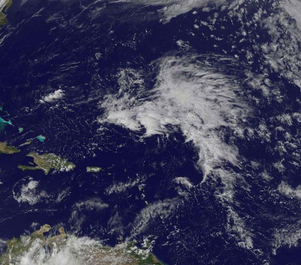
Tropical System Could Bring Early Start to Hurricane Season

Low Pressure System
© NOAA/NASA GOES Project
Hurricane season doesn't start in the Northern Atlantic Ocean until June 1, but one low pressure system wants to make an early debut.

There's a low pressure area with a small chance for development north-northeast of Puerto Rico, and NASA's GOES-13 satellite captured a visible image of the storm.

The National Hurricane Center (NHC) issued a Special Tropical Weather Outlook yesterday, April 20, that noted the low pressure area was located about 460 miles (740 kilometers) northeast of San Juan, Puerto Rico at 3:35 p.m. EDT. The NHC noted that slow development is possible over next couple of days. The low is moving west -northwest at 10 mph (16 kph).