Extreme Temperatures
S

Snowflake Cold

Arctic air to invade most of U.S. this week

man in snow
The coldest and most widespread blast of arctic air so far this season will spread across the majority of the United States this week.

Frigid air from the depths of the Arctic will plunge into the United States as the jet stream (a fast-river of air along which storms travel) drops southward.

The coldest days of next week will yield highs and lows generally 10-20 degrees Fahrenheit below normal from the Northwest to the Gulf and East coasts.


Departures from normal highs will even approach 30 degrees in Billings, Montana, and Denver, Colorado.

The arctic blast will first began to chill the Northwest this weekend, where pockets of snow and freezing conditions made some roads slippery.

The northern Rockies and northern Plains will face multiple days of highs in the single digits and teens. Subfreezing highs will then spread to the central Plains, Great Lakes and interior Northeast.

"Afternoon high temperatures in cities like Kansas City and St. Louis will only be in the 20s late in the week, while some places in the Dakotas may have a day or two where the temperature does not even get above zero," AccuWeather Meteorologist Brian Thompson said.

Snowflake

Hawaii now expected to receive 3 feet of snowfall

With a winter storm warning in effect through Saturday, the summits of Hawaii's Big Island could get more than two feet of snow.
Hawaii's highest peak could get up to another foot of snow Sunday, on top of the 2 feet that have fallen since Thursday, the National Weather Service says.

A winter storm warning is in effect for the summits of Mauna Loa and Mauna Kea through Saturday evening.

"Then we're expecting another round on Sunday and Sunday night," said Matthew Foster, a staff meteorologist with the National Weather Service in Honolulu.

The initial storm started on Thursday and was slowing down Saturday, "though some freezing drizzle is still possible," Foster said.

The next storm is currently about 400 miles west of the island of Kauai and should arrive over the islands sometime on Sunday, Foster said.

Comment: See also this earlier report: Over 2 feet of snow forecast for high ground in Hawaii


Cloud Grey

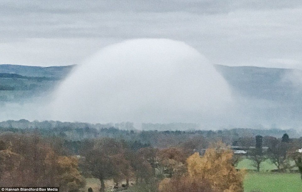
Rare 'fog dome' photographed near Tremeirchion, Wales

A rare UFO-like 'fog dome' (pictured here) was spotted by a dog walker in North Wales yesterday morning at 8am
Temperatures are expected to drop below freezing this weekend, prompting health officials to warn that the chilly conditions can be deadly.

Cold weather alerts have been issued for much of the country as forecasters expect 'severe cold weather' to set in today.

A rare UFO-like 'fog dome' was spotted by a dog walker in North Wales yesterday morning at 8am.

Hannah Blandford was with her pet in the village of Tremeirchion when she came across the spectacle which has been dubbed an 'alien pod'.

The 33-year-old who works as a teacher told The Sun: 'I couldn't believe how perfectly dome shaped it was, it looked amazing, so I had to take a photo. I'd never seen anything like it before, it was really quite special.

'I watched it for about 10 minutes and then the dome started to flatten and it looked like very thick low lying cloud. It spread out across 12 fields and covered a huge area.'

Forecasters think the fog dome was caused by heat rising up from the ground.

Forecasters think the fog dome was caused by heat rising up from the ground. Hannah Blandford, 33, was with her pet in the village of Tremeirchion when she came across the spectacle

Snowflake

Over 2 feet of snow forecast for high ground in Hawaii

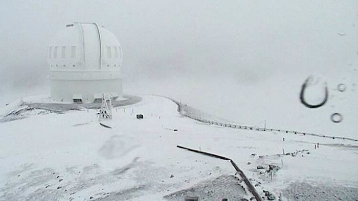
Snow at the Mauna Kea summit Friday afternoon
© UKIRTSnow at the Mauna Kea summit Friday afternoon
The summits of Hawaii's Big Island could get more than two feet of snow, with a winter storm warning in effect through Saturday.

A Winter Storm Warning is in effect through Saturday evening for elevations above 11,000 feet. The summits could get 20 to 30 inches of snow through Saturday, CBS affiliate KGMB.

An upper level low pressure area has brought the sub-freezing temperatures and unstable conditions. The low will combine with moisture surging in from the southeast, which could result in bursts of heavy snow, especially above 12,000 feet.

Conditions on the summits are dangerous. Besides being cold, east to southeast winds of 10 to 20 miles per hour are expected with higher gusts. The strong winds also will cause drifting snow, and freezing fog will reduce visibility to as low as a quarter of a mile.

It may be a while before you can see the white stuff up close. The road to the summit of Mauna Kea is closed at the Visitor Information Station at the 9,200-foot level due to freezing fog, heavy snow and icy roadways. The summit of Mauna Loa is also closed due to high winds and heavy snow. This means hiking and overnight camping is prohibited. The National Park Service said a thick blanket of snow was visible as low as 10,000 feet.


Snowflake

Snow records shattered on Prince Edward Island, Canada

These sorts of struggles are unusual for the end of November.
© Laura Meader/CBCThese sorts of struggles are unusual for the end of November.
If it seems like there is a lot snow on the ground on P.E.I. for early December, that's because there is.

In fact, there has been a record amount of snow on the ground. Charlottetown Airport broke records on both Nov. 30 and Dec. 1.

Previously, the snowiest end of November/start of December was in 1989. Those records for Nov. 27-29 stand, but 29 centimetres is a new record for Nov. 30 (17 in 1989) as is 32 for Dec. 1 (19 in 1989).

None of the storms this week broke snowfall records on their own, but in combination they have. Three storms brought snow to the Island in the space of five days, and the amount of snow was a surprise to everyone.

Igloo

Canadian mountain resort receives almost two meters of snow in a week

Whistler Blackcomb snowfall
© Via Twitter@ApresWheeler
Whistler Blackcomb has received over 190 centimetres of snow in the last seven days, and the powder won't stop falling anytime soon.

The mountain resort reports they have measured 26 centimetres of new snow in the last 12 hours, 86 centimetres in the last two days, and 192 centimetres in the last week. With only three days into the 2016/2017 winter season, they already have a base of 206 centimetres at mid-mountain.

For skiers and boarders planning on ending their weekend making fresh lines in the snow, the weather will continue to cooperate on Sunday and maybe even make way for some blue sky.

Temperatures will be frosty at -5 C up the mountain with sunny periods and flurries developing around noon, but winds gusting up to 45 km/h will add extra chill to the air. Forecasters at Whistler expect another four to eight centimetres to fall on Sunday and three to five to fall on Wednesday.

Snowflake Cold

Coldest November for the Netherlands since 1998

Frost
© Johan Neven / Wikimedia Commons
This month was the coldest November the Netherlands had since 1998. The average temperature for November, measured at De Bilt, came down to 5.5 degrees. On 12 days the minimum temperature dropped below zero, according to meteorological institute KNMI.

The hottest it was this month was in Westdorpe in Zeeland, where the maximum temperature was 15.2 degrees on November 1st. Despite the low temperatures, this November was quite sunny. There was about 85 hours of sunshine, compared to the November average of around 63 hours.

According to Weerplaza, this autumn is full of extremes. Temperatures in the Netherlands went from 33 degrees to -7 degrees in three months.

Snowflake Cold

Frigid air mass building in Alaska, poised to descend into lower 48 next week

Alaska temperature Nov. 29, 2016
Alaska is witnessing its coldest air in almost two years, and some of the biting chill is forecast to plunge into the western United States in about a week's time.

In Fairbanks on Tuesday morning, the temperature tanked to minus-31 degrees, ending a 624-day stretch in which it was warmer than that โ€” the second longest on record. Tuesday afternoon, the mercury only recovered to minus-21, ending a record-long 658-day stretch with highs above minus-10.

It was even colder in Bettles, Alaska, on Tuesday, where the temperature dropped to minus-41 with a bone-chilling wind chill of minus-53.

Statewide, it was the first time Alaska's daily temperature index was significantly below normal in almost a year.

Comment: From Paul Dorian at Vencore Weather:


Snowflake

Winter storm forces stretches of I-94, I-90 to close in parts of North Dakota and South Dakota

Snow on road
The North Dakota Department of Transportation and Highway Patrol have closed eastbound and westbound Interstate 94 from Mandan to Dickinson because of the winter snowstorm affecting most of central and western North Dakota.

In South Dakota, Interstate 90 was closed in the northern Black Hills from Rapid City to Spearfish.

On the 94-mile stretch of interstate from Mandan to Dickinson, the patrol said parts are blocked with heavy snow drifts along with extremely icy and snow compacted stretches. The patrol also said there was near zero visibility at times creating hazardous driving conditions.

The portion of the interstate was expected to remain closed throughout Tuesday night

Snowflake Cold

This year's extreme heat attributed to El Nino, not greenhouse emissions - globe sees net COOLING this year

temperature drop
Stunning new data indicates El Nino drove record highs in global temperatures suggesting rise may not be down to man-made emissions
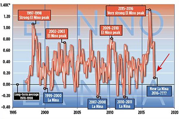
Global average temperatures over land have plummeted by more than 1C since the middle of this year - their biggest and steepest fall on record. According to satellite data, the late 2016 temperatures are returning to the levels they were at after the 1998 El Nino.

The news comes amid mounting evidence that the recent run of world record high temperatures is about to end. The fall, revealed by NASA satellite measurements of the lower atmosphere, has been caused by the end of El Nino - the warming of surface waters in a vast area of the Pacific west of Central America.

Some scientists, including Dr Gavin Schmidt, head of NASA's climate division, have claimed that the recent highs were mainly the result of long-term global warming.

Others have argued that the records were caused by El Nino, a complex natural phenomenon that takes place every few years, and has nothing to do with greenhouse gas emissions by humans.

The new fall in temperatures suggests they were right.
  • Global average temperatures over land have plummeted by more than 1C
  • Comes amid mounting evidence run of record temperatures about to end
  • The fall, revealed by Nasa satellites, has been caused by the end of El Nino
Big El Ninos always have an immense impact on world weather, triggering higher than normal temperatures over huge swathes of the world. The 2015-16 El Nino was probably the strongest since accurate measurements began, with the water up to 3C warmer than usual.

It has now been replaced by a La Nina event - when the water in the same Pacific region turns colder than normal.
Comment: See also: