Earthquakes
S

Bizarro Earth

US: Arizona - Earthquake Rattles Winslow Near Dormant Volcanoes

Image
© USGS
The U.S. Geological Survey recorded a magnitude 3.1 earthquake in Arizona Sunday afternoon. According to the USGS, the quake hit at 12:11 p.m. about 21 miles southwest of Winslow and about 113 miles northeast of Phoenix. (Winslow is about a 3-hour drive from Phoenix.) With a depth of just over 3 miles, the temblor was a relatively shallow one.

Google Earth shows the epicenter to be between what appear to be small dormant volcanoes. The volcano to the south of the epicenter is on the Colorado Plateau between the Mogollon Rim and Winslow. The remnants of the two cones to the north appeared to have been weathered away, leaving a plateau behind.

Google Earth also showed a sinkhole swarm not far from the epicenter. Meteor Crater, one of the best-known meteorite impact craters on the planet, is 20 miles west of Winslow, putting it in the circumference of the quake.

Bizarro Earth

Santa Cruz Islands - Earthquake Magnitude 6.6

Santa Cruz Quake_090112
© USGS
Date-Time
Monday, January 09, 2012 at 04:07:16 UTC

Monday, January 09, 2012 at 03:07:16 PM at epicenter

Time of Earthquake in other Time Zones

Location
10.557ยฐS, 165.160ยฐE

Depth
38.9 km (24.2 miles)

Region
SANTA CRUZ ISLANDS

Distances
75 km (46 miles) WNW of Lata, Santa Cruz Islands, Solomon Isl.

355 km (220 miles) E of Kira Kira, San Cristobal, Solomon Isl.

584 km (362 miles) ESE of HONIARA, Guadalcanal, Solomon Islands

2266 km (1408 miles) NE of BRISBANE, Queensland, Australia

Bell

Earthquake north of Anchorage is felt, but no reports of damage

Anchorage, Alaska - A small earthquake rumbled in Alaska that was felt in several small communities north of Anchorage.

The U.S. Geological Survey says the magnitude 4.0 temblor struck shortly before 10 p.m. Saturday and was centered about 150 northeast of Anchorage.

Target

Quake rattles Dominican Republic

Dominican quake
© USGS
Santo Domingo - A moderate tremor of 5.3 magnitude has rattled the entire Dominican Republic, at around 5:32am local time, whose epicenter was located 17 kilometers south-southeast of the city of San Jose de Ocoa, at a depth of 10 kilometers.

The tremor shook doors and windows for around 30 seconds, startling people to scurry out of bed.

Emergency Operations Center director Juan M. Mendez said there are no reports of damages or injuries thus far, although cracks in structures have been reported in the country's south region.

Jose Mateo, on the phone from the town of Fundacion, in the southern city of Bani, said his house under construction "has some cracks," with no major damages.

Bizarro Earth

Greece: Increased Seismic Activity at Dangerous Santorini Caldera

Image
© Expolrecrete.comThe eruption of the Santorini Volcano
The seismic unrest beneath Santorini which had started in July 2011 continues into 2012, greeting the world with a small swarm of quakes beneath the caldera.

The slightly increased number of quakes is concentrated on the volcano-tectonic Kameni line, which stretches SW-NE through the caldera and extends outside, especially to the NE where the submarine volcano Kolumbo is located 8 km off the coast. The alignment defines a tectonic graben structure underlying Santorini and has been used for rising magma for nearly all past eruptions of the volcano.

Attention

Indonesia: Recent Earthquakes Rattling East Java Have Agitated Volcanoes

Image
© lombokmarine.comMount Semeru or Gunung Semeru
People living in the vicinity of three volcanoes in East Java have been warned to be on the alert as they were showing signs of increased volcanic activity. The three volcanoes are Mt Ijen, Mt Semeru and Mt Bromo. East Java district disaster management head Timur Siswanto said the authorities were in a state of readiness to handle any volcanic disasters and had established command posts for relief work should any of the volcanoes erupt.

He was reported as saying by the local media that Mt Ijen was showing the most activity and that people living in its vicinity had been warned not to come within a 1.5 kilometer radius of the mountain. Besides the above three, five other volcanoes - Mt Gamalama (Ternate Island, Moluccas), Mt Papandayan (Garut, West Java), Gunung Karangetang (northern Sulawesi ), Gunung Lokon (northern Sulawesi) and Anak Krakatau (Sunda Strait) - were also reported to have started "rumbling."

Bizarro Earth

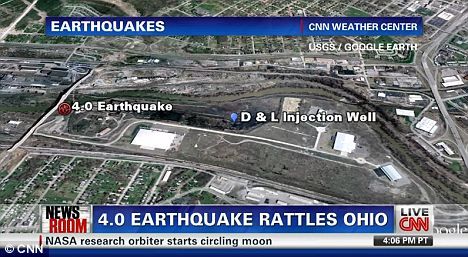
Ohio, US: Ohio finishes the year with earthquake as fears grow it was caused by oil drilling

Ohio Nearby
© CNNNearby: Officials are saying that the 10 earthquakes in Ohio this year- including Saturday's 4.0 one- are likely caused by drilling for oil and gas
The latest in a series of minor earthquakes in northeast Ohio hit on Saturday, this time reaching a magnitude of 4.0 on the Richter scale.

The tremor sent some stunned residents running for cover as bookshelves shook and pictures and lamps fell from tables.

The quake struck Saturday afternoon in McDonald, outside of Youngstown, the U.S. Geological Survey said.

Area residents said a loud boom accompanied the shaking, but sheriff's dispatchers from several counties in the area said there were no immediate reports of damage.

A few miles from the epicenter, Charles Kihm said he was preparing food in his kitchen when he heard a noise and thought a vehicle had hit his Austintown home.

'It really shook, and it rumbled, like there was a sound,' said Mr Kihm, 82.

'It was loud. It didn't last long. But it really scared me.'

Bizarro Earth

US: 4.0 earthquake strikes in northeast Ohio

McDonald - Officials said Saturday they believe the latest earthquake activity in northeast Ohio is related to the injection of wastewater into the ground near a fault line, creating enough pressure to cause seismic activity.

The brine wastewater comes from drilling operations that use the so-called fracking process to extract gas from underground shale. But Ohio Department of Natural Resources Director Jim Zehringer said during a news teleconference that fracking is not causing the quakes.

"The seismic events are not a direct result of fracking," he said.

Environmentalists and property owners who live near gas drilling wells have questioned the safety of fracking to the environment and public health. Federal regulators have declared the technology safe, however.

Bizarro Earth

Magnitude 7.0 quake hits Japan

Tokyo - A 7.0-magnitude earthquake struck under the sea south of Japan on Sunday, shaking buildings in the capital but causing no apparent damage or tsunami.

The quake struck near the uninhabited island of Torishima in the Pacific Ocean, about 370 miles south of Tokyo, and its epicenter was about 230 miles below the sea, the Meterological Agency said. It did not generate a tsunami.

Buildings in the Tokyo area shook, but no damage or injuries were reported. Express trains in northern and central Japan were suspended temporarily for safety checks but later resumed.

No abnormalities were reported at power plants, including the crippled nuclear power plant in northeast Japan hit by the March earthquake and tsunami, public broadcaster NHK reported.

Bizarro Earth

Japan - Earthquake Magnitude 6.8 - Izu Islands

Japan Quake_010112
© USGS
Date-Time
Sunday, January 01, 2012 at 05:27:54 UTC

Sunday, January 01, 2012 at 02:27:54 PM at epicenter

Time of Earthquake in other Time Zones

Location
31.416ยฐN, 138.155ยฐE

Depth
348.5 km (216.6 miles)

Region
IZU ISLANDS, JAPAN REGION

Distances
242 km (150 miles) SW of Hachijo-jima, Izu Islands, Japan

365 km (226 miles) S of Hamamatsu, Honshu, Japan

393 km (244 miles) S of Shizuoka, Honshu, Japan

495 km (307 miles) SSW of TOKYO, Japan