Earthquakes
S


Bizarro Earth

8.9 Aceh quake triggers Indian Ocean tsunami warning

An earthquake with an initial magnitude of 8.9 has struck under the sea off Indonesia's northern Aceh province.

The quake triggered a tsunami warning across the Indian Ocean region.

The Pacific Tsunami Warning Center said it was not yet known whether a tsunami had been generated, but advised authorities to "take appropriate action".

The region is regularly hit by earthquakes. The Indian Ocean tsunami of 2004 killed 170,000 people in Aceh.

The US Geological Survey, which documents quakes worldwide, said the Aceh quake was centred 33km (20 miles) under the sea about 495km from Banda Aceh, the provincial capital.

It was initially reported as 8.9 magnitude but was later revised down to 8.7 by the USGS.

The tsunami warning said quakes of such a magnitude "have the potential to generate a widespread destructive tsunami that can affect coastlines across the entire Indian Ocean basin".

Bizarro Earth

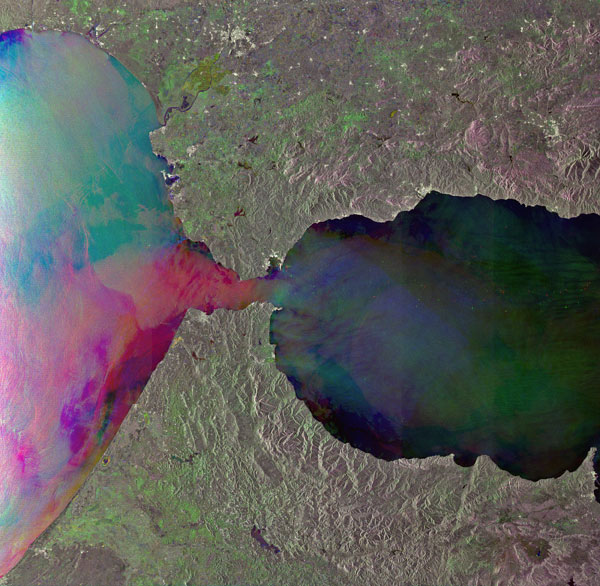
What's Happening Under Gibraltar?

The Strait of Gibraltar
© ESAThe Strait of Gibraltar, which lies between the southern coast of Spain and the northern coast of Morocco, is the only place where water from the Atlantic Ocean mixes with water from the Mediterranean Sea.
The ground beneath Portugal, Spain and northern Morocco shook violently on Nov. 1, 1755, during what came to be known as the Great Lisbon Earthquake. With an estimated magnitude of 8.5 to 9.0, the temblor nearly destroyed the city of Lisbon and its lavish palaces, libraries and cathedrals. What wasn't leveled by the quake was mostly demolished in the ensuing tsunami and fires that raged for days. Altogether, at least 40,000 people were killed.

More than 250 years later, geologists are still piecing together the tectonic story behind that powerful earthquake. A unique subduction zone beneath Gibraltar, the southernmost tip of the Iberian Peninsula, now seems to be culprit. Subduction zones are the spots where one of Earth's tectonic plates dives beneath another, often producing some of the world's strongest earthquakes.

"At a global scale, subduction is the only process that produces magnitude-8 or -9 earthquakes," said Marc-Andre Gutscher, a geologist at the University of Brest in France. "If subduction occurred, and is still occurring here, then it's highly relevant to understanding the region's seismic hazards."


Bizarro Earth

Papua New Guinea - Earthquake Magnitude 6.2

PNG Quake_060412
© USGSEarthquake Location
Date-Time
Friday, April 06, 2012 at 16:15:55 UTC

Saturday, April 07, 2012 at 02:15:55 AM at epicenter

Time of Earthquake in other Time Zones

Location
4.534°S, 153.497°E

Depth
85.4 km (53.1 miles)

Region
NEW IRELAND REGION, PAPUA NEW GUINEA

Distances
52 km (32 miles) E of Taron, New Ireland, PNG

150 km (93 miles) ESE of Rabaul, New Britain, PNG

884 km (549 miles) NE of PORT MORESBY, Papua New Guinea

2543 km (1580 miles) N of BRISBANE, Queensland, Australia

Bizarro Earth

USGS: Earthquake Magnitude 6.3 - Oaxaca, Mexico

Image
© USGS
Date-Time:
Monday, April 02, 2012 at 17:36:43 UTC
Monday, April 02, 2012 at 12:36:43 PM at epicenter

Location:
16.477°N, 98.287°W

Depth:
12.3 km (7.6 miles)

Region:
OAXACA, MEXICO

Distances:
27 km (17 miles) SSE (148°) from Ometepec, Guerrero, Mexico

33 km (21 miles) WNW (302°) from Pinotepa Nacional, Oaxaca, Mexico

109 km (68 miles) SW (216°) from Tlaxiaco, Oaxaca, Mexico

176 km (109 miles) SE (133°) from Chilpancingo, Guerrero, Mexico

179 km (111 miles) ESE (103°) from Acapulco, Guerrero, Mexico

Bizarro Earth

San Diego rattled by 3 loud booms, violent shaking following tremor 4 miles from Palomar Observatory

Image
© USGS
The USGS confirmed a small earthquake struck San Diego County Thursday night. The quake struck with a magnitude of 3.3 and at a depth of 7 miles at 11:09 p.m. The epicenter of the earthquake was four miles south-southeast of the Palomar Observatory, 17 miles northeast of Escondido and 39 miles north-northeast of San Diego, according to a computer-generated USGS report.

News stations in the area said they received over a dozen calls from concerned viewers who described the earthquake as very loud and said it was accompanied by three eerie booms. There were also reports of violent shaking. No injuries or damage was reported the tremor. No one in our generation remembers so many small tremors across the world triggering so many sonic booms. One has to wonder what is happening in the earth beneath our feet.

Blackbox

Clintonville residents shaken once again by mysterious booms

Clintonville, Wisconsin - Residents are shaken by booms once again in a small Wisconsin city where a small earthquake was recorded last week. Clintonville police say they received 65 calls Tuesday night between 10:35 and 11:40 from residents who experienced the booming. The city has been relatively quiet lately after the booms awakened residents for several days early last week.

The U.S. Geological Survey said a 1.5-magnitude earthquake struck March 20 in Clintonville, a town of about 4,600 people about 40 miles west of Green Bay.

City administrator Lisa Kuss says she has again contacted the Geological Survey about the latest booms.

Bizarro Earth

Earthquake Magnitude 6.0 - Near the East Coast of Honshu, Japan

Honshu Quake_270312
© USGSEarthquake Location
Date-Time
Tuesday, March 27, 2012 at 11:00:43 UTC

Tuesday, March 27, 2012 at 08:00:43 PM at epicenter

Time of Earthquake in other Time Zones

Location
39.866°N, 142.116°E

Depth
10 km (6.2 miles)

Region
NEAR THE EAST COAST OF HONSHU, JAPAN

Distances
85 km (52 miles) ENE of Morioka, Honshu, Japan

90 km (55 miles) SE of Hachinohe, Honshu, Japan

157 km (97 miles) SE of Aomori, Honshu, Japan

509 km (316 miles) NNE of TOKYO, Japan

Bizarro Earth

Earthquake Magnitude 6.0 - Northern East Pacific Rise

Pacific Quake_260312
© USGSEarthquake Location
Date-Time
Monday, March 26, 2012 at 18:12:54 UTC

Monday, March 26, 2012 at 11:12:54 AM at epicenter

Time of Earthquake in other Time Zones

Location
10.198°N, 104.030°W

Depth
9.9 km (6.2 miles)

Region
NORTHERN EAST PACIFIC RISE

Distances
568 km (352 miles) E of Clipperton Island

862 km (535 miles) SSW of Acapulco, Guerrero, Mexico

864 km (536 miles) SSW of Zihuatanejo, Guerrero, Mexico

1146 km (712 miles) SSW of MEXICO CITY, D.F., Mexico

Bizarro Earth

USGS: Earthquake Magnitude 7.1 - Maule, Chile

Image
© USGS
Date-Time:
Sunday, March 25, 2012 at 22:37:06 UTC
Sunday, March 25, 2012 at 06:37:06 PM at epicenter

Time of Earthquake in other Time Zones

Location:
35.183°S, 71.792°W

Depth:
34.8 km (21.6 miles)

Region:
MAULE, CHILE

Distances:
27 km (16 miles) NNW of Talca, Maule, Chile

55 km (34 miles) WSW of Curico, Maule, Chile

99 km (61 miles) NNE of Cauquenes, Maule, Chile

219 km (136 miles) SSW of SANTIAGO, Region Metropolitana, Chile

Radar

Magnitude 7.2 Earthquake Hits Central Chile

Santiago feels effects of 7.2 tremor with emergency agency evacuating some coastal areas, although tsunamis not expected
Image
© The Associated Press/Fabian SuazoPeople gather outside a supermarket after an earthquake was felt in Talca, Chile, Sunday, March 25, 2012.
A magnitude 7.2 earthquake hit central Chile on Sunday, shaking buildings in the capital Santiago and the government emergency agency, ONEMI, said it was preventively evacuating some areas of the coast.

The quake struck 64 miles (103 km) west north west of the town of Talca at a depth of 6.2 miles (10 km), the US Geological Survey said.

Magnitude 7.0 quakes or greater are capable of causing widespread, heavy damage.

ONEMI said, however, that the quake was not expected to generate a tsunami off the coast.

The latest earthquake hit near the same central region that struck by a massive 8.8 magnitude earthquake in 2010 and tsnunamis in 2010 that killed about 500 people.

The central area is home to some important copper mines, but the bulk of output in the world's top copper exporting nation is concentrated in the far northern region.

Source: Reuters