Earthquakes
S


Bizarro Earth

USGS: Earthquake Magnitude 6.1 - ESE of Ozernovskiy, Russia

Russian Quake_240313
© USGS
Event Time
2013-03-24 04:18:34 UTC
2013-03-24 15:18:34 UTC+11:00 at epicenter

Location
50.718°N 160.155°E depth=9.7km (6.0mi)

Nearby Cities
269km (167mi) ESE of Ozernovskiy, Russia
274km (170mi) SSE of Vilyuchinsk, Russia
278km (173mi) SSE of Petropavlovsk-Kamchatskiy, Russia
300km (186mi) SSE of Yelizovo, Russia
2341km (1455mi) NE of Tokyo, Japan

Technical Details

Bizarro Earth

Study warns a Nankai trough earthquake would displace 10 million people in Japan, and kill 323,000

Image
A Japanese government panel is estimating that a 9.0 magnitude earthquake in the Nankai Trough region will do damage worth $2.2 billion, a figure that is much higher than the $177 million from the Great East Japan Earthquake of 2011. Scientists are predicting that the earthquake is due "in the not-too-distant future", based on historical rough calculations. These figures do not include the possible nuclear fallout from an earthquake of that magnitude. The panel also predicts the number of evacuees to reach 9.5 million a week after it hits and that 40 out of the country's 47 prefectures will suffer damage to their infrastructure. 27.1 million will suffer power outages, while 34.4 million will be without water.

In an earlier report released in August, the panel said around 323,000 could die from an earthquake with its epicenter in the Nankai Trough, also a big number compared to the 19,000 who died or were reported missing in the 2011 disasters. But if all houses and key buildings are already quake-resistant by the time the earthquake will occur, the damage can be cut to almost half at $836 million. That is why the government's priority would be to come up with basic policy measures by the end of the month against future earthquakes. The Nankai trough runs from the gulf of Suruga, Shizuoka Prefecture, central Japan, to the sea of Hyuga, off Miyazaki Prefecture in the southwestern Japan region of Kyushu. Historically, this area experiences 8.0 magnitude earthquakes once every 100 to 150 years, with the last one occurring last 1946, where around 1,330 people perished. - JDP

Bizarro Earth

19 miners rescued in Poland, after 4.7 magnitude earthquake causes mine collapse

Emergency services in western Poland have rescued 19 miners who were trapped underground when a minor earthquake caused a tunnel to collapse. The workers at Rudna copper mine in Lower Silesia were trapped for about eight hours while rescuers dug through earth and rock to reach them. The mine is owned by Poland's largest copper miner, KGHM, and has operated since 1969. A KGHM spokesman said the accident happened 600m (2,000ft) below ground. He said the rescue operation was "difficult because huge amounts of rocks have to be removed."

The tremor that caused the tunnel to collapse, lasted about 10 seconds, the BBC's Adam Easton reports from the capital, Warsaw. One miner had a gash on his head, but all those who were rescued were fit enough to go home. The mine is some 400km (250 miles) south-west of Warsaw. Accidents there are relatively uncommon. Poland has a large number of mines, many of which are located in the industrialized Silesia region, which is rich in mineral and natural resources. - BBC


Bizarro Earth

USGS: Earthquake Magnitude 4.7 - 3km NE of Polkowice, Poland

Image
© USGS
Event Time
2013-03-19 21:09:52 UTC
2013-03-19 22:09:52 UTC+01:00 at epicenter

Location
51.529°N 16.108°E depth=3.7km (2.3mi)

Nearby Cities
3km (2mi) NE of Polkowice, Poland
15km (9mi) NNW of Lubin, Poland
15km (9mi) S of Glogow, Poland
30km (19mi) NNE of Chojnow, Poland
199km (124mi) NE of Prague, Czech Republic

Technical Data

Bizarro Earth

Earth reeling from spasm of quakes: seismic stress could be building towards an event?

The planet is currently reeling from a dense spectrum of moderate to light tremors, which have struck along major tectonic plate boundaries over the last 18 hours. As a precursor to this seismic dynamism; we have seen elevated activity at many of the world's volcanoes, including hotspots in Hawaii, Etna, and the Canary Islands. The latest spat of seismic activity across the globe has every indication of being a precursor to a major seismic stress release, which I have forecasted since last week. This event could be hours, or even days away. The window of elevated hazard risk, at present, extends through March 23, and is annunciated by the spring equinox. - TEP

Image

Bizarro Earth

USGS: Earthquake Magnitude 6.1 - E of Bristol Island, South Sandwich Islands

Sandwich Island Quake_190313
© USGS
Event Time
2013-03-19 03:29:00 UTC
2013-03-19 01:29:00 UTC-02:00 at epicenter

Location
58.915°S 24.410°W depth=31.3km (19.4mi)

Nearby Cities
121km (75mi) E of Bristol Island, South Sandwich Islands
2666km (1657mi) ESE of Ushuaia, Argentina
2900km (1802mi) SE of Rio Gallegos, Argentina
2906km (1806mi) ESE of Punta Arenas, Chile
2241km (1392mi) SE of Stanley, Falkland IslandsTechnical Details

Bizarro Earth

Rare earthquakes rattle Auckland

Auckland Quake
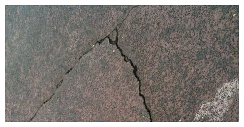
© Tamaryn PeddieDriveway cracks after the earthquake in Unsworth Heights North Shore.
A "moderate" 3.9 magnitude earthquake that struck Auckland today was the biggest in the city since February 2007, GeoNet says.

The tremor, which struck at 4.05pm, was five kilometres deep and was centred near Motatapu Island, 15 kms north-east of the city.

GeoNet described its intensity as "moderate".

"It's quite rare to get any felt events in Auckland, but occasionally we do have some like this," said duty officer Nico Fournier.

He said the earthquake did not indicate an increase in volcanic activity under New Zealand's biggest city, which is dotted with volcanoes.

"Because we have volcanoes in Auckland and then we had this earthquake it doesn't mean the two are related. There is no indication of that."

Further earthquakes were possible, he said.

"Usually when you get earthquakes there are aftershocks, so certainly in the next hours or days there is a possibility of further small earthquakes, but right now it's looking pretty calm.

"There's no indication that it will be the case, but we can't exclude it."

Fire Service spokesman Jaron Phillips said the northern communications centre fielded calls about the quake from across Auckland.
Bizarro Earth

USGS: Earthquake Magnitude 5.1 - Southern California

Image
© USGS
Event Time:
2013-03-11 16:55:42 UTC
2013-03-11 09:55:42 UTC-07:00 at epicenter

Location:
33.506°N 116.476°W depth=0.1km (0.1mi)

Nearby Cities:
19km (12mi) ESE of Anza, California
23km (14mi) SW of La Quinta, California
25km (16mi) SSW of Palm Desert, California
26km (16mi) SSW of Rancho Mirage, California
409km (254mi) W of Phoenix, Arizona

Technical Data

Bizarro Earth

USGS: Earthquake Magnitude 6.7 - ESE of Finschhafen, Papua New Guinea

PNG Quake_100313
© USGS
Event Time
2013-03-10 22:51:56 UTC
2013-03-11 08:51:56 UTC+10:00 at epicenter

Location
6.748°S 148.242°E depth=84.3km (52.4mi)

Nearby Cities
44km (27mi) ESE of Finschhafen, Papua New Guinea
139km (86mi) E of Lae, Papua New Guinea
180km (112mi) ENE of Wau, Papua New Guinea
182km (113mi) ENE of Bulolo, Papua New Guinea
320km (199mi) NNE of Port Moresby, Papua New Guinea

Technical Details

Evil Rays

Earthquake in southwest China destroys 700 homes, injures 30 people

Image
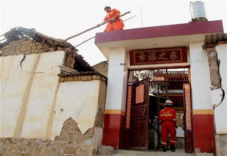
© AP Photo/Xinhua, Ge ShangnengIn this photo released by China's Xinhua News Agency, firefighters work on a damaged building after a 5.5-magnitude earthquake hit Eryuan County of Dali Bai Autonomous Prefecture, southwest China's Yunnan Province, Sunday, March 3, 2013. The moderate earthquake caused hundreds of homes to collapse and injured at least 30 people.
A moderate earthquake struck southwest China on Sunday, causing hundreds of homes to collapse and injuring at least 30 people.

The earthquake bureau in Yunnan province, where the quake occurred, said three of the injured people were in serious condition.

The official Xinhua News Agency said the quake damaged 2,500 houses and caused 700 others to collapse.