Earthquakes
S


Camera

Images - Japanese Earthquake and Tsunami

A massive 8.9-magnitude quake hit northeast Japan on Friday, causing dozens of deaths, more than 80 fires, and a 10-meter (33-ft) tsunami along parts of the country's coastline. Homes were swept away and damage is extensive.

Below is a stunning collection of photographs which show some of the devastation in Japan:

Image
© REUTERS/KYODOBuildings burn near Sendai Airport, northeastern Japan in the aftermath of the record 8.9 magnitude earthquake March 11, 2011.
Image
© Reuters/KyodoPeople take shelter as a ceiling collapses in a bookstore in the city of Sendai.

Camera

NASA Satellite Photos Show Devastation From Japan Quake and Tsunami

Image
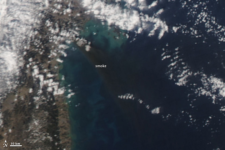
© MODIS Rapid Response Team/NASA GSFCThis image from NASA's Aqua satellite shows a major fire raging near the coastal city of Sendai in northeastern Japan after the massive 8.9-magnitude earthquake that struck on March 11, 2011. This image was taken by Aqua's MODIS instrument on March 12.
NASA satellites have snapped new pictures of the devastating floods and fires in Japan from the deadly earthquake and tsunami that struck the country on Friday (March 11).

Photos from NASA's Earth-watching Terra and Aqua satellites paint a stark picture from above of the damage by the massive 8.9-magnitude earthquake and the subsequent tsunami it spawned. They show Japan's northern region, particularly the city of Sendai - which is visible inundated by floodwaters and fires in the satellite views.

The images were taken today (March 12) - one day after the natural disaster as part of NASA's MODIS Rapid Response system, which uses satellites to provide near real-time images of Earth's landmasses every day. The system can snap photos of Japan twice a day, NASA officials said. [Japan Earthquake and Tsunami in Pictures]

Better Earth

Japan Quake Shifted Earth 4 Inches on Its Axis

Image
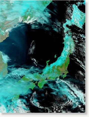
© ReutersNASA's Terra satellite's first view of northeastern Japan flooding following the earthquake and tsunami in northeastern Japan
The powerful earthquake that unleashed a devastating tsunami Friday appears to have moved the main island of Japan by 8 feet (2.4 meters) and shifted the Earth on its axis.

"At this point, we know that one GPS station moved (8 feet), and we have seen a map from GSI (Geospatial Information Authority) in Japan showing the pattern of shift over a large area is consistent with about that much shift of the land mass," said Kenneth Hudnut, a geophysicist with the U.S. Geological Survey (USGS).

Attention

After quake, 10,000 missing in Japan

Image
© Unknown
Following the massive earthquake in northern Japan, nearly 10,000 people are unaccounted for in the port town of Minamisanriku in Miyagi Prefecture.

The figure is more than half of the town's population of 17,000, Japan Broadcasting Corporation NHK announced on Saturday.

On Friday, an 8.9-magnitude earthquake, off the northeastern coast of Japan's main island, unleashed a 23-foot (7-meter) tsunami and was followed by more than 50 aftershocks for hours.

Bizarro Earth

Japan pre-dawn quakes cause landslides in Niigata

Image
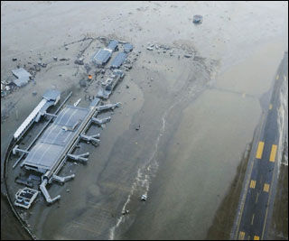
© UnknownThe tarmac and surrounding area of Sendai Airport is covered with water after a tsunami.
Tokyo - A strong 6.7-magnitude earthquake felt in Tokyo hit Japan's mountainous Niigata prefecture and caused landslides and avalanches at 4:00 am Saturday (1900 GMT Friday).

Kyodo News said there were no immediate reports of casualties and no fresh tsunami alert was issued after the quake, which was followed by an almost equally strong quake in the same area half an hour later.

The quakes struck in the west of the main Honshu island, on the Sea of Japan coast and far from the offshore Pacific Ocean tremor that triggered a mammoth tsunami Friday that is feared to have killed more than 1,000 people.

The focus of both predawn quakes was in central Niigata.

The US Geological Survey put the strength at 6.2 and said it hit at a depth of only one kilometre (about half a mile).

Police said they had received reports of a landslide and avalanche in Tokamachi and another avalanche in Tsunan town, Kyodo reported.

The news agency also said wooden buildings including a town hall and a garage had reportedly been destroyed and some highways cracked in the village of Sakae in Nagano prefecture.

The first quake in the inland region struck at 4:00 am Saturday (1900 GMT Friday). The focus was in central Niigata but it also shook neighbouring Nagano, and a third quake later followed in the region.
Nuke

Huge blast at Japan nuclear power plant


A massive explosion has struck a Japanese nuclear power plant after Friday's devastating earthquake.

A huge pall of smoke was seen coming from the plant at Fukushima and several workers were injured.

Japanese officials fear a meltdown at one of the plant's reactors after radioactive material was detected outside it.

A huge relief operation is under way after the 8.9-magnitude earthquake and tsunami, which killed more than 600.

Hundreds more people are missing and it is feared about 1,300 may have died.

The offshore earthquake triggered a tsunami which wreaked havoc on Japan's north-east coast, sweeping far inland and devastating a number of towns and villages.

Bizarro Earth

Japan Earthquake Triggered Volcano Eruption In Russia?

Eruption
© PlanetSave
The major earthquake that hit Japan today may have just triggered some volcanoes in Russia as well. While reports are still vague on the incident, there is a strong correlation between the two occurrences. In Russia, there are reports that earthquakes where felt during the eruption.


Bizarro Earth

Earthquake and Tsunami near Sendai, Japan

Honshu Quake
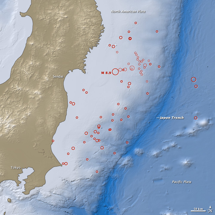
© Earth Observatory, NASANASA Earth Observatory image created by Robert Simmon and Jesse Allen, using earthquake and plate tectonics data from the USGS Earthquake Hazard Program, land elevation data from the Shuttle Radar Topography Mission (SRTM) provided by the University of Maryland’s Global Land Cover Facility, and ocean bathymetry data from the British Oceanographic Data Center’s Global Bathmetric Chart of the Oceans (GEBCO).
On March 11, 2011, at 2:46 p.m. local time (05:46 Universal Time, or UTC), a magnitude 8.9 earthquake struck off the east coast of Japan, at 38.3 degrees North latitude and 142.4 degrees East longitude. The epicenter was 130 kilometers (80 miles) east of Sendai, and 373 kilometers (231 miles) northeast of Tokyo. If initial measurements are confirmed, it will be the world's fifth largest earthquake since 1900 and the worst in Japan's history.

This map shows the location of the March 11 earthquake, as well as the foreshocks (dotted lines) and aftershocks (solid lines). The size of each circle represents the magnitude of the associated quake or shock. The map also includes land elevation data from NASA's Shuttle Radar Topography Mission and ocean bathymetry data from the British Oceanographic Data Center.

According to the U.S. Geological Survey (USGS), the earthquake occurred at a depth of 24.4 kilometers (15.2 miles) beneath the seafloor. The March 11 earthquake was preceded by a series of large foreshocks on March 9, including an M7.2 event. USGS reported that the earthquakes "occurred as a result of thrust faulting on or near the subduction zone interface plate boundary."

Bizarro Earth

Tonga: Earthquake Magnitude 6.1 - 12th March

Tonga Quake_120311
© USGSEarthquake Location
Date-Time:
Saturday, March 12, 2011 at 01:19:07 UTC

Saturday, March 12, 2011 at 02:19:07 PM at epicenter

Time of Earthquake in other Time Zones

Location:
16.727°S, 173.174°W

Depth:
10.9 km (6.8 miles)

Region:
TONGA

Distances:
106 km (65 miles) SE of Hihifo, Tonga

229 km (142 miles) NNE of Neiafu, Tonga

355 km (220 miles) SSW of APIA, Samoa

2528 km (1570 miles) W of Auckland, New Zealand

Blackbox

Japan's quake shifts earth's axis by 25 centimetres

Image
© Wikipedia
Initial results out of Italy's National Institute of Geophysics and Volcanology show that the 8.9-magnitude earthquake that rattled Japan Friday shifted the earth's rotation axis by about 25 centimetres.

INGV's report, which came hours after the devastating incident, is equivalent to "very, very tiny" changes that won't be seen for centuries, though, Canadian geologists say.

Only after centuries would a second be lost as each day is shortened by a millionth of a second, according to University of Toronto geology professor Andrew Miall.

"Ten inches sounds like quite a lot when you hold a ruler in front of you. But if you think of it in terms of the earth as a whole, it's absolutely tiny; it's minute," he said.

"It's going to make minute changes to the length of a day. It could make very, very tiny changes to the tilt of the earth, which affects the seasons, but these effects are so small, it'd take very precise satellite navigation to pick it up."