OF THE
TIMES

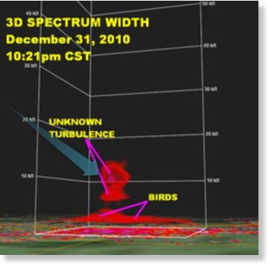
"There it was. This huge plume of turbulence over the Beebe birds just as they began their frenzied flight," Johnson said.Having homed in on the probable cause, Johnson then introduced some nonsense:
The turbulence appears above the birds between about 7,000 and 12,000 feet. Johnson realized there are only a few possible explanations for this phenomena.
"Birds don't fly that high, and he quickly ruled out military action, a sonic boom, meteor shower or alien invasion."While we can understand why Johnson ruled out military action or a sonic boom (there were no flights over the area at the time), Johnson never explained why he ruled out a "meteor shower", although we can understand the inclusion of "alien invasion" - to ridicule by association the idea of a "meteor shower" or other meteorite-related phenomenon.
"Something in the atmosphere, something mysterious, occurred over Beebe, Arkansas that night... And I believe it was part of what caused those birds to fly and then die."Indeed, but with the answer staring him in the face, Johnson lost the plot completely:
Johnson's research captured an unseen temperature reversal just above the birds' roosting area at about 1,500 feet above the ground. This temperature "inversion" acted like a megaphone, amplifying all the noises that occurred in Beebe at that time. As the fireworks exploded, the sound was amplified by the inversion and became much louder than normal. This appears to have startled the birds so much that they burst into flight, running into each other, and nearby buildings. Thousands of the now-disoriented birds then crashed to the ground, dying from blunt force trauma.

India Ferry Capsizes Due to Heavy Rain and Winds; 103 Dead, 100 MissingAbnormal Cold or Heat
Wettest April in 100 years - Sodden Britain braces for more floods
Flash floods kill 27 in Afghanistan- scores missing
Huge Dust Storm Swallows Iowa College Campus
Britain to see month's rain in one night as severe weather warnings issued
Widespread floods in Kenya kill 15 as 50,000 left homeless
At least 30 killed following flash flood in Takhar province, Afghanistan
More deadly floods strike north Afghanistan, 10,000 left homeless
Violent rainstorm wreaks havoc in North-Eastern France
Hurricane Season Comes Early This Year
Freak storm lashes Cannes film festival, soaking stars
Hurricane Bud could bring life-threatening conditions to Mexico
Hurricane Bud heading for area near Puerto Vallarta
North Korean Farmers Cite Grave Drought; Aid Unlikely
Montreal Floods: Heavy Rain Causes Power Failures, Shut Down Parts Of Metro
Rare April Freezing Rain in BrazilSinkholes
Forget The Floods And Get Ready To Shiver
Frost kills early blooms in Ontario, apple crop losses to top $100M
Farmers worry that May snow and freezing temperatures could bring crop failures to Britain
Scotland colder than the ARCTIC as country hit by snow and freezing weather
Hot Enough for You? Warmest May to April Ever for U.S
Britain's Coldest May in 300 Years
Unusual cold weather wiped out two of Morocco's primary crop exports
Northeast Ohio wine grapes destroyed by hard freeze
The Ice Age Cometh! Heavy snow surprises Bosnians after a hot weekend in mid May
First Time in 50 Years - Snow Hits Bosnian Capital
Snow and unusual weather in the UK Midlands
'Scientific experts' confounded by increasing snow cover on Mount Kilimanjaro
Late-season storm could bring summer snow to Sierra, California
Perth's Coldest May Night in 98 Years
Family's terror as their Florida house is nearly engulfed by 100ft wide sinkholeHail, Tornadoes and Typhoons
Sinkhole in Arkansas parking lot swallows SUV
Update: Massive Florida Sinkhole Expanding
Three sinkholes open up in Prince William County, Virginia
Huge sinkhole opens in Montreal after student protest
Massive Sinkhole Forms Near Central City, Colorado
Anoka County, Minneapolis sinkhole is growing
Deadly tornado rips through eastern JapanEarthquakes
More Weird Weather: Supercell brings tornado to England
Twin Waterspouts Caught on Camera
40 Die in Chinese Hailstorm
Freak storm brings never seen before hail to Philippines, homes destroyed
Hailstorm rips through Cuttack, India, Capital hit too
Tornado Hits Weimar, Texas
Tornado damages 15 homes in North Port, Florida
Tornado Confirmed on Ground near Wausau, Wisconsin
Tornadoes strafe Kansas, damaging homes; 1 hurt
Tornadoes cause heavy property damage near Montreal
USGS: Earthquake Magnitude 5.7 - Michoacan, MexicoMass Animal Deaths
USGS: Earthquake Magnitude 6.0 - Offshore Chiapas, Mexico
Cascadia tension: earthquake swarm continues off the coast of Vancouver
Azerbaijan hit with strongest earthquake in 4 years- swarm of tremors follow
Civil Defense of Peru issues earthquake warnings after two days of abnormal tremor activity
5.3 Magnitude Earthquake Rocks Israel and Palestine
5.4 Magnitude Earthquake Rocks Northeast India
Moderate earthquake hits Tajikistan: USGS
USGS: Earthquake Magnitude 6.2 - Tarapaca, Chile
USGS: Earthquake Magnitude 6.0 - Papua New Guinea
USGS: Earthquake Magnitude 6.2 - Off The Coast of Aisen, Chile
USGS: Earthquake Magnitude 6.0 - Northern Italy
Update: Powerful quake kills at least 3 in northern Italy
In pictures: Italy earthquake
USGS: Earthquake Magnitude 6.0 - Off The East Coast of Honshu, Japan
M6.2 quake and several above M5.0 hit off Northeast Japan in last day
USGS: Earthquake Magnitude 5.6 - Bulgaria
Japan Quake Aftershock Tally Exceeds 5,000
USGS: Earthquake Magnitude 6.1 (Magnitude Changed to 6.0) - Hokkaido, Japan
Magnitude 5.8 Bulgarian Earthquake Followed By 80 Aftershocks, Worst in Region Since 1917
USGS: Earthquake Magnitude 6.2 - Norwegian Sea
Earthquake Magnitude 4.8 shakes nervous Christchurch, sending shoppers fleeing into the streets
5.6 earthquake which jolted Bulgaria was strongest since 1858, and the aftershocks continue
USGS: Earthquake Magnitude 6.0 - Bonin Islands, Japan Region
Fourth earthquake rocks East Texas
USGS: Earthquake Magnitude 6.7 - Santiago Del Estero, Argentina
USGS: Earthquake Magnitude 5.8 - Northern Italy (aftershocks included)
Update: Italy Hit by 2nd Deadly Quake in Days; Death Toll at 16
32 Dead Porpoises Worry Wildlife ExpertsVolcanoes
Fish Pond in Shenzhen Ravaged Overnight
Peru pelican and dolphin deaths prompt warning to stay off beaches
Mysterious fish kill under investigation in Kuwait
Mystery Surrounds Dead Pelicans Found Along Indian River
Peru Says 5,000 Birds, Nearly 900 Dolphins Dead
2,300 Birds Found Dead Along Chilean Beaches
Mass Bird Deaths: Mystery Linked To El Nino
Pacific Mystery: What's Killing the Dolphins and the Pelicans?
Bee Kills and Genetic Engineering in the Corn Belt
Dead Fish Pile up on Mula-Mutha Banks
Dolphin Deaths in Peru: The Mystery Deepens
60,000 to 100,000 dead fish wash up eastern shores of U.S. near Chesapeake Bay
Black Sea Ecologists Alarmed By Dolphin Deaths
Hundreds of Endangered Antelopes Dying in Kazakhstan
Thousands of Shellfish Found Dead in Peru
Mount Asphyxia Volcano Erupts - South Sandwich IslandsFires
Popocatepetl Volcano Threatens Millions with Gas and Ash, Mexico on High Alert
Increased Volcanic Activity at Mt. Baekdu
Pagan Island Volcano Erupts in Mariana Islands
Icelandic volcano warming up for eruption: Small glacier flood continues at Katla
Mexico Volcano Spews Huge Ash Cloud, Frightens Villagers
Growing fears that huge North Korean volcano will soon erupt
Blasts Continue to Menace People Near Popocatepetl Volcano
Dramatic eruption seen at Sakurajima volcano in Japan
Guatemala Fuego Volcano Spits Lava and Ash
Is an eruption at Costa Rica's Turrialba Volcano imminent?
Residents evacuated near Costa Rica's Turrialba volcano after gas emission
Growing unrest: preventive alert declared for three Costa Rican volcanoes
500 evacuated from vicinity of Colombia's Nevado del Ruiz volcano
Three Forest Fires Burn Out of Control in Alberta; Fire Ban in EffectMiscellaneous
Clouds of Smoke, Ash from Forest Fire Lead to State of Emergency in Timmins
Wildfires Hit Six U.S. States, Small Towns Evacuated
Mysterious smell detected in Tel Aviv, Israel'Climate Change'
Mystery smell in Tel Aviv: Source still unknown
Source of Vibrating Houses Traced to Methane Gas From Landfill
Mysterious Noises, Vibrations Reported in Austin
Mystery Earthquake Near McCall Puzzles Scientists, Technicians
Purple Skies
'Roll Clouds' Filmed in Texas, Montana 29-30 May
Greenland Glaciers Are Speeding Up
Bering Sea Sees Surprising Record Ice Cover
Destabilization: Scientists discover new unstable region the size of New Jersey under Antarctica Ice Sheet
Researchers find New Zealand more seismically unstable than previously thought
Japan's Mt. Fuji a Ticking Time-bomb? Scientists Find 30 km Long Active Fault
Sumatra Volcanoes May Pack Deadly Punch
In less than 24 hours, Lake Cachet II in Chile's southern Patagonia vanished
Rise and Fall of Underwater Volcano Revealed
Last Ice Age took just SIX months to arrive
Global Cooling on the Way? Lake Sediment Proves Sun Cooled Earth 2,800 Years Ago and Could Happen Again Soon!
Japan tornado: Temperature differences spawned supercell storm
Belief That CO2 Can Regulate Climate Is 'Sheer Absurdity' Says Prominent German Meteorologist
Canadian Journalist exposes UN IPCC 'leading scientists' to be ideologically compatible grad students
US Offense Secretary Panetta: Climate change a national security threat
Global Warming Propaganda Alert! NASA Scientist James Hanson Says Civilization Will Be At Risk if Canada Exploits Oil Sands
Climate Change Nonsense: Dinosaur flatulence may have led to global warming
