Earth ChangesS

Radar

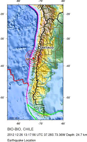
Magnitude 5.5 earthquake at Bio-Bio, Chile, 26 December 2012

Image
© neic.usgs.gov
Magnitude: 5.5

Date-Time: Wednesday, December 26, 2012 at 13:17:56 UTC

Location: 37.281ยฐS, 73.363ยฐW

Depth: 24.7 km (15.3 miles)

Region: BIO-BIO, CHILE

Distances:
11 km (6 miles) WSW of Arauco, Chile

19 km (11 miles) NNW of Curanilahue, Chile

33 km (20 miles) SW of Lota, Chile

40 km (24 miles) NNE of Lebu, Chile
Location Uncertainty: horizontal +/- 19.7 km (12.2 miles); depth +/- 5.1 km (3.2 miles)

Parameters: NST=315, Nph=330, Dmin=283.9 km, Rmss=0.62 sec, Gp= 68ยฐ,

M-type=body wave magnitude (Mb), Version=B

Source:
Magnitude: USGS NEIC (WDCS-D)

Location: USGS NEIC (WDCS-D)
Event ID: usc000eg5v

Cloud Lightning

Severe U.S. snowstorm kills five

Image
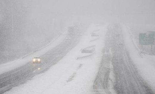
© AP Photo/The Gleaner, Mike LawrenceTraffic moves in the U.S. 41 By-Pass in Henderson, Ky., Wednesday, Dec. 26, 2012 as a snow storm moves through the area making travel treacherous.
A powerful winter storm that has claimed at least five lives pounded the US midwest and northeast and disrupted post-Christmas travel last night.

Heavy snow and high winds prompted National Weather Service blizzard and winter storm warnings for the Ohio River Valley and into the Northeast. Approximately 37cm of snow was recorded at New Baltimore, Michigan, as the storm headed north and east. An estimated 200,000 thousand people are without electricity.

About 1,500 US flights were cancelled yesterday, according to FlightAware.com, a site that tracks flights. Some 170 flights also have been called off today, and several airlines waived ticket change fees for affected customers.

All four runways at Philadelphia International Airport were open, but some travellers still faced some cancelled flights.

The National Weather Service warned that between 30 to 45cm of snow was expected in northern New England, with snow falling through until tomorrow morning. The storm was accompanied by freezing rain and sleet, making driving treacherous, it said.

Cloud Lightning

Videos: Tornado descends on Mobile, Alabama, exploding power transformers and lifting SUVs clear off the ground

It was a white Christmas in many parts of the U.S., and while the weather made the holidays pretty to look at it also caused plenty of holiday chaos. More than 10 inches of snow fell on parts of central and northern Arkansas, with the state capital Little Rock receiving 9 inches - breaking an 86-year-old snowfall record. Parts of southern Illinois and Indiana found themselves digging out from 7-inches of accumulation on Christmas Day.

But the worst weather hit parts of Alabama and Louisiana, where tornadoes slammed into Gulf Coast towns on Christmas Day. In Mobile, Ala., one twister touched down just before 5 p.m., and was captured live by local news station WALA.


Cloud Lightning

Christmas storm brings record tornado outbreak in Southern U.S., heavy snow, rain to North

Image
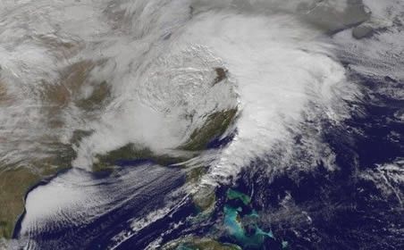
© NOAASatellite image of the storm in the early afternoon of 26 Dec.. Notice the circulation, and convection firing off along the cold front on the eastern side.
From a record Christmas Day tornado outbreak to today's heavy snows in the Ohio Valley, interior Mid-Atlantic and Northeast, the storm coming up the East Coast has left quite a mark.

On Christmas Day, more than 30 tornado reports were logged from eastern Texas to southern Alabama. That number easily exceeds the most previously recorded (12 in 1969) on December 25 (dating back to 1950). The twisters caused some damage, but there have been no reports of fatalities, fortunately.

Although no tornadoes have touched down so far today, a tornado watch is in effect for eastern North Carolina through 5 p.m. ET.

While tornadoes swarmed near the Gulf Coast, double digit snowfall totals were recorded in Arkansas, Illinois, Indiana and Missouri Christmas Day.

Heavy snows are blanketing parts of West Virginia, Pennsylvania, western Maryland, and Ohio on this Boxing Day - with strong winds creating near blizzard conditions in some areas.

Here are a few more impressive images and photos of the storm...

Camera

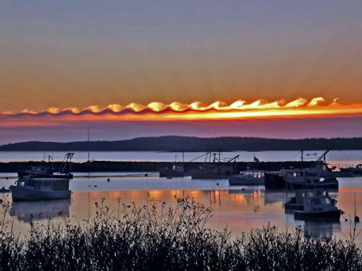
'Wave Clouds' roll across morning Maine sky

On Christmas morning, Gene Hart of Jonesport, Maine, woke up early to enjoy the sunrise before opening presents. What he saw may have been the best gift of all. "There was a cloud formation showing a remarkable series of wave shapes," says Hart. "They were backlit by the rising sun over Moosabec Reach." He snapped this picture of the harbor using a 14-megapixel digital camera:
Image
© Gene Hart

Comment: Somehow it doesn't seem likely that this is what Van Gogh had in mind when he painted Starry Night. These 'Wave Clouds' and similarly novel clouds have been appearing a lot more often in recent years:

US: Giant Tsunami-Shape Clouds Roll Across Alabama Sky


Moon

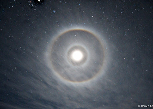
Double halo appears around Quarter Moon, 21 December 2012

Many sky watchers have witnessed a halo around the moon--a ring of light that surrounds the lunar disk at a radius of 22 degrees. The phenomenon is caused by pencil-shaped ice crystals in cirrus clouds that bend moonlight. On Dec. 21st, Harald Edens of Magdalena, New Mexico, witnessed a rare double halo:

Image
© Harald Edens

Comment: Moon halos usually appear in conjunction with a full moon, but on 21st December the moon was only at first quarter. Besides producing two halos, the planet's changing atmosphere probably made it appear to be full.

See also: Chemtrails, Disinformation and the Sixth Extinction


Snowflake

'Pretty nasty' snow storm to hit Ontario, parts of Quebec and New Brunswick

Image
© Wayne Cuddington , Ottawa CitizenFile photo of a winter storm in Ottawa, Ontario.
Toronto - Environment Canada warned Wednesday that a dangerous winter storm was moving into the southern and eastern regions of Ontario as the weather system works its way up from the U.S.

The agency said in a special weather statement that much of the province will be walloped by snow starting Wednesday afternoon as the outer reaches of a weather system making its way north from Kentucky crosses the border.

Meteorologist Arnold Ashton said the system will move on to deliver snow to parts of southern Quebec and New Brunswick on Thursday.

"It's the combination of snow and blowing snow that makes this particularly nasty," Ashton said.

Environment Canada said the areas of Dunnville and Niagara in southwestern Ontario and the stretch between Kingston and Cornwall in the east will bear the worst of the storm, getting 15 to 20 centimetres of snow.

The weather agency said other communities in those regions can expect up to 15 cm of snow, while central Ontario residents should get their snow shovels ready for 5 to 10 cm.

Airplane

About 200 Philadelphia flights cancelled due to storm

Philadelphia - The winter storm has led to the cancellation of a couple hundred flights at Philadelphia International Airport as well as delays in departures and arrivals.

Airport spokeswoman Victoria Lupica said Wednesday evening that the airport had recorded about 200 cancelled flights due to the winter weather.

She said there have also been delays in arriving and departing flights, with arrivals delayed four hours or more.

The University Park airport in State College in central Pennsylvania said Wednesday night that it had closed due to the storm but planned to reopen Thursday.

Passengers and people coming to pick them up are urged to contact airlines to check on flight status, or check with the airport on its website (www.phl.org ) or toll-free flight information number (1-800-745-4283).

Source: The Associated Press

Igloo

Numerous Japanese cities reach record lows as freezing temperature persist

Heavy Snow
© The Japan Daily Press
As Japan continues to deal with a persisting cold front, Christmas Day brought record low temperatures to as many as 44 locations, mostly in the northern region and on the island of Hokkaido. The Japan Meteorological Agency warned that cold temperatures would last throughout the week, with more heavy snowfall in the north and areas that face the Sea of Japan.

Tuesday saw temperatures setting a record low for the month of December, with Hokkaido's city of Furano reaching minus 28.4 degrees, the coldest ever recorded since monitoring began. Record lows were also made in Tokyo, at 6 degrees, and the prefectures of Tottori and Saitama with minus 8 degrees. Homes and offices in Japan very rarely have central heating systems, and windows are poorly insulated, making it sometimes difficult to keep warm in the winter. People instead rely on kerosene-powered space heaters, creating a high demand for oil. In areas where snowfall makes it difficult to drive, gasoline stations drive trucks around with tanks of fuel and long hoses, making deliveries so people don't even have to leave their homes.

The city of Monbetsu, also in Hokkaido, reported a meteorological phenomenon known as ice fog occurring on Tuesday. The meteorological agency says this takes place when the water vapors from the ocean rise and meet cold air on land to form thick, low-hanging clouds of very cold fog.

Windsock

Christmas day tornados kill three in U.S.

Three people were killed as tornados struck four US states on Christmas Day. Twisters first pounded Texas. Others then touched down in Louisiana and Mississippi. One headed straight for the centre of Mobile, Alabama tearing up residential and commercial areas causing severe power cuts.