Earth ChangesS

Bizarro Earth

Cascadia fault line in North America: A now still and silent subduction zone where disaster awaits

Image
On a dark winter's night in January 1700 a tsunami struck Japan. It flooded fields, swept away villages for miles inland and cost many lives. Even as far back as 1700 the Japanese had made the connection between earthquakes and Tsunami, but this time there was no earthquake, no warning to allow the people time to evacuate to higher ground. The tsunami was called the 'orphan tsunami' because it had no 'parent' earthquake. For more than 300 years the origin of the orphan tsunami remained a mystery.

In the 1980s Hiroo Kanamori and Tom Heaton published a paper that said the 1700 tsunami was caused by a massive rupture of the Cascadia fault line that runs off the west coast of the United States from California to Vancouver. In 1987 Brian Atwater studied soil samples far inland across the length of the fault and discovered that the United States had also suffered a tsunami at the same time as the Japanese. He concluded that Kanamori and Heaton were correct, a massive earthquake had sent a tsunami out from the source of the quake inundating the coasts on both sides of the Pacific.

Recent studies by researchers at the University of Pennsylvania has concurred on the findings of previous studies.

House

Video: Ground crumbles and buildings collapse as apocalyptic floods sweep India


Bizarro Earth

Moderate 5.7 magnitude earthquake shakes buildings in Chile's capital

Image
© USGS
A magnitude-5.7 earthquake shook central Chile on Wednesday, causing buildings to sway in the capital but apparently causing no major damage. The U.S. Geological Survey said the quake struck at 17:29 p.m. local time and its epicenter was about 60 kilometers (37 miles) east-north-east of Los Andes, Chile. Officials discarded the possibility of a tsunami and said there were no immediate reports of deaths or damages. Chile is one of the world's most earthquake-prone countries. A magnitude-8.8 quake and the tsunami it unleashed in 2010 killed more than 500 people and destroyed 220,000 homes. - ABC

Bizarro Earth

Singapore haze at worst yet, Malaysia schools shut

Image
© The Associated Press/Mark BakerA woman checks her mobile phone as she walks past Malaysia's landmark Petronas Twin Towers in Kuala Lumpur, Malaysia, Thursday, June 20, 2013.
Singapore urged people to remain indoors amid unprecedented levels of air pollution Thursday as a smoky haze wrought by forest fires in neighboring Indonesia worsened dramatically. Nearby Malaysia closed 200 schools and banned open burning in some areas.

The Pollutant Standards Index, Singapore's main measure for air pollution, surged to a record reading of 371, breaching the "hazardous" classification that can aggravate respiratory ailments. The previous all-time high before this week was in 1997, when the index reached 226.

The hazardous reading lasted three hours before easing to 253 in the evening, still "very unhealthy."

Smog fueled by raging Indonesian blazes has hit Singapore and Malaysia many times, often in the middle of the year, but the severity of this week's conditions has strained diplomatic ties. Officials in Singapore say Jakarta must do more to halt fires on Sumatra island started by plantation owners and farmers to clear land cheaply.

"This is now the worst haze that Singapore has ever faced," Singapore's Environment Minister Vivian Balakrishnan wrote on his Facebook page. "No country or corporation has the right to pollute the air at the expense of Singaporeans' health and wellbeing."

The haze has shrouded the city-state's skyscrapers in a pall of noxious fumes and posed numerous inconveniences for Singaporeans, some of whom complained of coughs and covered their faces with handkerchiefs while walking outdoors.

Bizarro Earth

Why is Africa ripping apart? Seismic scan may tell

Great Rift Valley
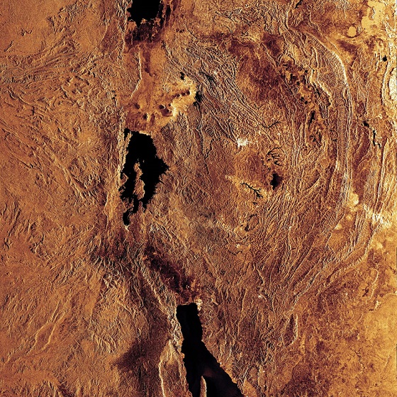
© ESAThis radar image highlights portions of three of the lakes located in the Western Rift of the Great Rift Valley, a geological fault system of Southwest Asia and East Africa: Lake Edward (top), Lake Kivu (middle) and Lake Tanganyika (bottom).
Arrays of sensors stretching across more than 1,500 miles in Africa are now probing the giant crack in the Earth located there - a fissure linked with human evolution - to discover why and how continents get ripped apart.

Over the course of millions of years, Earth's continents break up as they are slowly torn apart by the planet's tectonic forces. All the ocean basins on the Earth started as continental rifts, such as the Rio Grande rift in North America and Asia's Baikal rift in Siberia.

The giant rift in Eastern Africa was born when Arabia and Africa began pulling away from each other about 26 million to 29 million years ago. Although this rift has grown less than 1 inch (2.54 centimeters) per year, the dramatic results include the formation and ongoing spread of the Red Sea, as well as the East African Rift Valley, the landscape that might have been home to the first humans.

"Yet, in spite of numerous geophysical and geological studies, we still do not know much about the processes that tear open continents and form continental rifts," said researcher Stephen Gao, a seismologist at the Missouri University of Science and Technology in Rolla, Mo. This is partly because such research has mostly focused on mature segments of these chasms, as opposed to ones that are still in development, he explained.

Cloud Precipitation

Floods close Lourdes pilgrimage site in Pyrenees

Image
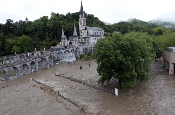
© AP Photo/Bob EdmeThe sanctuary of Lourdes flooded, in Lourdes, southwestern France, Tuesday, June 18, 2013. French rescue services and police are evacuating hundreds of pilgrims from hotels threatened by floodwaters from a rain-swollen river in the Roman Catholic shrine town of Lourdes.
Heavy floods in southwest France have left two dead and forced the closure of the Catholic pilgrimage site in Lourdes and the evacuation of pilgrims from nearby hotels.

Muddy floodwaters swirled Wednesday in the grotto where nearly 6 million believers from around the world, many gravely ill, come every year seeking miracles and healing. It has been a major pilgrimage site since a French girl's vision of the Virgin Mary there in 1858.

Heavy rains around the region inundated town centers and swelled the Gave de Pau river, forcing road closures.

Interior Minister Manuel Valls said on BFM television that a man in his seventies died Wednesday, swept away by the river. The Interior Ministry says it is the second person who has died in this week's rains.

The spokesman for the Lourdes pilgrimage complex, Mathias Terrier said that the site in the foothills of the Pyrenees wasn't likely to reopen before the end of the week.

Rescue services evacuated hundreds of people from nearby hotels. Authorities were particularly concerned with bringing weak and sick pilgrims to safety.

Bizarro Earth

Largest methane seep in the world found off the eastern coast of U.S.

On the seafloor just off of the U.S. East Coast lies a barely known world, explorations of which bring continual surprises. As recently as the mid-2000s, practically zero methane seeps - spots on the seafloor where gas leaks from the Earth's crust - were thought to exist off the East Coast; while one had been reported more than a decade ago, it was thought to be one of a kind. But in the past two years, additional studies have revealed a host of new areas of seafloor rich in seeps, said Laura Brothers, a research geologist at the U.S. Geological Survey. New technologies have allowed scientists to keep locating new seeps, including one that may be the largest in the world. The findings have changed geologists' understanding of the processes taking place beneath the seafloor. "These newly discovered [seafloor] communities show that there is much more seafloor methane venting then we previously thought, and suggests that there are many more seeps out there that we don't know about," Brothers said.
Image
An even larger, previously unknown vent was found off the coast of Virginia, in research by Steve Ross, a scientist at the University of North Carolina at Wilmington, and Sandra Brooke, a scientist at Florida State University. Discovered near the Norfolk submarine canyon, the vent is the largest in the Atlantic, and possibly in all of the world's oceans, Ross told LiveScience. North America's continental shelf, the underwater edge of the continent that borders the Atlantic Ocean basin, is littered with underwater canyons etched by rivers thousands of years ago when the region was above sea level.

Bizarro Earth

Scientists fear tension building on dangerous fault near Istanbul, Turkey

German and Turkish scientists on Tuesday said they had pinpointed an extremely dangerous seismic zone less than 20 kilometers (12 miles) from the historic heart of Istanbul. Running under the Sea of Marmara just south of the city of some 15 million people, this segment of the notorious North Anatolian fault has been worryingly quiet in recent years, which may point to a buildup in tension, they wrote. "The block we identified reaches 10 kilometers (about six miles) deep along the fault zone and has displayed no seismic activity since measurements began over four years ago," said Marco Bohnhoff, a professor at the German Research Centre for Geosciences (GFZ) in Potsdam, near Berlin. "This could be an indication that the expected Marmara earthquake could originate there."
Image
The North Anatolian fault, created by the collision of the Anatolia Plate with the Eurasia Plate, runs 1,500 kilometers (950 miles) along northern Turkey. At the western tip of the fault, an earthquake took place in 1912 at Ganos near the Aegean Sea. On its eastern side, a domino series of earthquakes in 1939, 1942, 1951, 1967 and 1999 displaced the stress progressively westwards, bringing it ever closer to Istanbul. What is left now is a so-called earthquake gap under the Sea of Marmara, lying between the two fault stretches whose stress has been eased by the quakes. The "gap" itself, however, has not been relieved by an earthquake since 1766. Seeking a more precise view of the gap, the GFZ and Istanbul's Kandilli Earthquake Observatory set up a network of seismic monitors in the eastern part of the sea. They calculate that the Anatolian fault normally has a westward motion of between 25 and 30 millimeters (one to 1.2 inches) per year.

Sun

Baked Alaska - Unusual heat wave hits 49th state

A heat wave hitting Alaska may not rival the blazing heat of Phoenix or Las Vegas, but to residents of the 49th state, the days of hot weather feel like a stifling oven - or a tropical paradise. With temperatures topping 80 degrees in Anchorage, and higher in other parts of the state, people have been sweltering in a place where few homes have air conditioning.

Image
© Associated PressThis photo taken Monday, June 17, 2013, shows people sunning at Goose Lake in Anchorage, Alaska.
They're sunbathing and swimming at local lakes, hosing down their dogs and cleaning out supplies of fans in at least one local hardware store. Mid-June normally brings high temperatures in the 60s in Anchorage, and just a month ago, it was still snowing. The weather feels like anywhere but Alaska to 18-year-old Jordan Rollison, who was sunbathing with three friends and several hundred others lolling at the beach of Anchorage's Goose Lake.

"I love it, I love it," Rollison said. "I've never seen a summer like this, ever." State health officials even took the unusual step of posting a Facebook message reminding people to slather on the sunscreen. Some people aren't so thrilled, complaining that it's just too hot. "It's almost unbearable to me," said Lorraine Roehl, who has lived in Anchorage for two years after moving here from the community of Sand Point in Alaska's Aleutian Islands. "I don't like being hot. I'm used to cool ocean breeze."

Cloud Grey

Tornado touches down at Denver International Airport

denver airport tornado
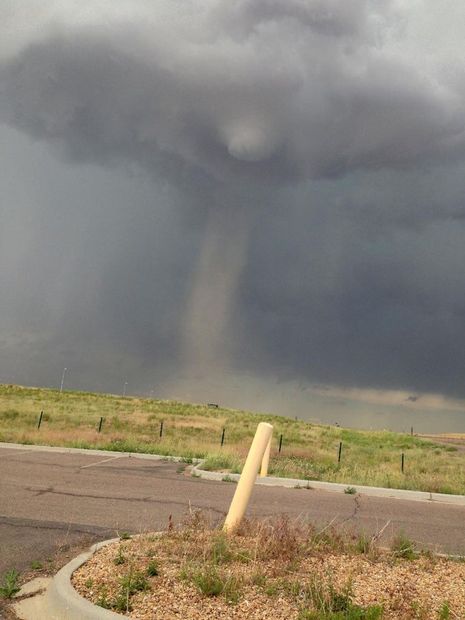
© AP Photo/Scott MorlanThis Tuesday, June 18, 2013 image provided by Scott Morlan shows a tornado that touched down near Denver International Airport.
Radar indicated a tornado briefly touched down Tuesday over the east runways of Denver International Airport, where thousands of people took shelter in bathrooms, stairwells and other safe spots until the dangerous weather passed, officials said.

Airport spokeswoman Laura Coale reported no damage. Nine flights were diverted elsewhere during a tornado warning that lasted about 40 minutes, she said.

A 97 mph wind gust was measured at the airport before communication with instruments there was briefly knocked out, said National Weather Service meteorologist Kyle Fredin.

Chris Polk, a construction foreman, was working on a renovation project just outside the airport's main concourse when he got the tornado warning at 2:15 p.m., looked up and saw a funnel cloud. He and his crew ran inside and took shelter with some 100 people, including luggage-toting passengers, inside a basement break room as tornado sirens sounded.

"It got pretty crazy around here," Polk said.

Asked whether he was nervous when he spotted the funnel cloud, he shrugged. "No, I'm from Missouri," he said.

Everyone inside the break room was calm, Polk added.