Earth ChangesS

Snow Globe Xmas

Earth gains a record amount of sea ice in 2013

Earth has gained 19,000 Manhattans of sea ice since this date last year, the largest increase on record. There is more sea ice now than there was on this date in 2002.
Change in global sea ice area
© Unknown
timeseries.global.anom.1979-2008

Cloud Precipitation

Utah flooding hits schools, homes as wet weather continues

flooding issues near Herrriman High
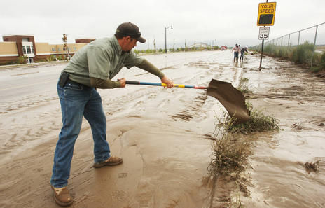
© Jeffrey D. Allred, Deseret NewsCity crews work on flooding issues near Herrriman High School due to heavy rain in Herriman on Saturday, Sept. 14, 2013.

Heavy rains caused flooding problems Saturday, particularly in areas of southern Salt Lake County, where water went over roads and into homes and schools.

In Herriman, flooding near 11600 South and 6000 West sent water into two buildings of the Farmgate Apartment complex around 3 p.m., affecting 18 apartment units and displacing 10 people, Unified Fire Authority Capt. Clint Mecham said.

A minimal amount of water also entered nearby Herriman High School, but the water level later abated and crews were working on cleanup efforts. Mecham said it did not appear that the flooding would impede classes from being held Monday morning.

Cloud Precipitation

Sudden massive storm set to slam UK and Ireland as atmospheric pressure plummets

Stormy seas
© The MirrorStormy seas are expected
Met Eireann forecast severe winds and rain "countrywide"


Ireland risks rush-hour disruption today as a 100kph "weather bomb" threatens to topple trees, blocking roads and causing problems for cars, planes and ferries.

Autumn's first storm, which forecasters said was more powerful than usual for September, saw wind gusts hit 83kph at Malin Head, Co Donegal, yesterday morning.

And Met Eireann forecast more fierce wind gusts "countrywide" today after yesterday's severe weather warning for wind gusts up to 100kph in Munster, Leinster, Connacht, and specifically Donegal, Monaghan and Cavan.

Cloud Precipitation

Boulder flooding: Remembering warnings from 'Weather Report'

Rain
© Jonathan Kos-Read (CC BY-ND 2.0)
On Thursday as I was reading about war and peace, headlines about a flash flood in Boulder kept arriving all through the day: "At least 3 dead in Colorado flooding; Boulder 'overwhelmed with water'" (LA Times), "Flood threat still strong as 3 killed in Colorado" (USA Today), "Boulder flood: 2nd death confirmed, county calls in National Guard to assist with rescues" (Boulder Daily Camera), "Boulder Flooding: Deadly High Waters in Northern Colorado Force Evacuations, Cause Mudslides" (Huffington Post), ...

Soon I'll talk about the flood, but first the warning.

Windsock

Extreme weather: Parts of Wales could be hit by 60mph winds for the next few days

extreme weather
© Wales OnlineSome parts of Wales are expected to experience bad weather over the next few days
Yellow weather warning in place as parts of Wales braces itself for strong winds and heavy rain


The Met Office has issued a yellow weather warming for most of the UK - with Denbighshire, Flintshire, Conwy, Anglesey and most of Gwynedd coming in for some of the worth weather.

According to forecasters, a deep area of low pressure will move eastward, bringing strong winds and heavy rain.

Because some parts of North Wales could be hit by gale force winds of up to 60mph, the Met Office said there could be some minor travel disruption.

Cloud Precipitation

Parts of New Mexico brace for more rain, clean up begins

New Mexico
© Weather.comTorrential Flooding in New Mexico
Another round of rainfall moved across New Mexico on Sunday, renewing the threat of heavy runoff from already saturated soils and flooding in low areas as residents faced a major cleanup effort from damage left in the wake of days of relentless rain.

The National Weather Service issued a flash flood watch for much of central and northern New Mexico. In the northeastern corner of the state, where the chance for heavy rain was greatest, residents who live along the Gallinas River were being warned that the waterway could swell again.

"As long as you get the right thunderstorm right over your area, I wouldn't be surprised if more records are broken as far as one-day rainfall totals because we still have that abundant moisture in the area," said Jason Frazier, a meteorologist with the National Weather Service in Albuquerque.

Windsock

Britain braced for chaotic weather as Force 11 gale winds strike

umbrella
© Getty Images
The first severe storms of autumn are set to unleash chaos across Britain tonight with winds as strong as 70mph felling trees.

Forecasters last night said almost the entire country will be lashed with violent gales measuring Force 11 and driving rain.

The weather system - caused by a deep area of low pressure over the Atlantic - is forecast to arrive later today but its fury will not be unleashed fully until tomorrow.

It will reach a peak tomorrow and last into Monday, meaning a soggy start to the working week.

People were advised to reach for their waterproofs and wellies but not to bother with umbrellas because they will only blow away.

Telephone

Dialing back the alarm on climate change

Later this month, a long-awaited event that last happened in 2007 will recur. Like a returning comet, it will be taken to portend ominous happenings. I refer to the Intergovernmental Panel on Climate Change's (IPCC) "fifth assessment report," part of which will be published on Sept. 27.

Hour glass
© Dadu Shin
There have already been leaks from this 31-page document, which summarizes 1,914 pages of scientific discussion, but thanks to a senior climate scientist, I have had a glimpse of the key prediction at the heart of the document. The big news is that, for the first time since these reports started coming out in 1990, the new one dials back the alarm. It states that the temperature rise we can expect as a result of man-made emissions of carbon dioxide is lower than the IPPC thought in 2007.

Admittedly, the change is small, and because of changing definitions, it is not easy to compare the two reports, but retreat it is. It is significant because it points to the very real possibility that, over the next several generations, the overall effect of climate change will be positive for humankind and the planet.

Specifically, the draft report says that "equilibrium climate sensitivity" (ECS) - eventual warming induced by a doubling of carbon dioxide in the atmosphere, which takes hundreds of years to occur - is "extremely likely" to be above 1 degree Celsius (1.8 degrees Fahrenheit), "likely" to be above 1.5 degrees Celsius (2.4 degrees Fahrenheit) and "very likely" to be below 6 degrees Celsius (10.8 Fahrenheit). In 2007, the IPPC said it was "likely" to be above 2 degrees Celsius and "very likely" to be above 1.5 degrees, with no upper limit. Since "extremely" and "very" have specific and different statistical meanings here, comparison is difficult.

Still, the downward movement since 2007 is clear, especially at the bottom of the "likely" range. The most probable value (3 degrees Celsius last time) is for some reason not stated this time.
Cloud Precipitation

Search-and-rescue teams to respond in flooded Colorado county

Colorado
© Fox News

Colorado Gov. John Hickenlooper will meet with FEMA administrator Craig Fugate on Monday to inform the public how they are responding to massive flooding in the state.

The Federal Emergency Management Agency is sending two 80-person search-and-rescue teams to assist with continuing rescues in Larimer County and providing aid to other communities following massive flooding that began Wednesday along the Front Range.

Hickenlooper told ABC's "Good Morning America" that 16 or 17 helicopters will resume searching for stranded residents Monday. Noting that many people have been without any kind of phone or Internet communications since the middle of last week, he says the focus of the effort is to make sure everyone in harm's way gets "out of there."

Cloud Precipitation

Scotland's weather: Storms show winter on the way

high winds
© Greg MacveanA woman struggles with her umbrella on Portobello Beach due to the high winds
Scotland experienced all four seasons in one day yesterday, as the first storm of autumn swept across the country, bringing chaos to the country's roads.

Torrential rain, accompanied by gale-force winds, gave way to sunny periods, before the wet weather returned.

The Cairngorms were hit by gusts of 100mph, with snow anticipated last night, and the Forth Road Bridge was closed to high-sided vehicles after wind speeds of 69mph were recorded.

However, not everyone was bemoaning the gales. The weather was perfect for Scottish Windfest, at Barassie Beach in Troon, where windsurfers and kitesurfers were competing.