Earth ChangesS

SOTT Logo Media

SOTT Focus: SOTT Earth Changes Summary - June 2026: Extreme Weather, Planetary Upheaval, Meteor Fireballs

secs0626

June 2026 gave Solar Cycle 25's so-called declining phase its loudest month yet, and the following four weeks kept proving that "post-maximum" is not the same as "quiet." On the 3rd, Active Region 4455 fired three major flares within about ten hours of each other (an M9.3, an M7.7, and finally an X1.0), each throwing off a coronal mass ejection, with the X-class event triggering an R3-strong radio blackout across the sunlit hemisphere.

NOAA's Space Weather Prediction Center answered with a G3-strong geomagnetic storm watch for June 4 and 5, warning that the combined CMEs could push aurora as far south as Illinois and Oregon. The region's magnetic complexity kept forecasters on edge for days afterward.

That wasn't a one-off. AR4473 opened the solstice with an M3-class flare on June 21, and the month closed the way it began: on June 30, Region 4475 fired an M5.8, followed within hours by an X1.1 from neighboring Region 4479, causing a S1 minor radiation storm warning. NOAA's own tally for the final week of June counted one X-class flare, two dozen M-class flares, and fifty coronal mass ejections; the kind of numbers that belong to a rising cycle, not a fading one. "Post-maximum" describes an average. It was never a ceiling.

Seismograph

Magnitude 6.2 earthquake strikes off southern Philippines following series of Pacific Ring of Fire quakes - 5th mag. 6 in 11 days

mmmmmm
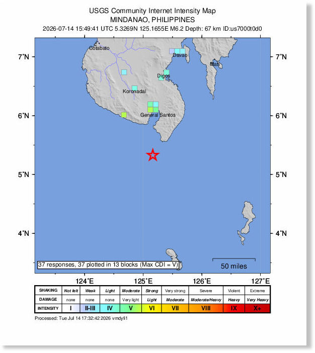
A magnitude 6.2 earthquake struck off the coast of the southern Philippines late Tuesday night.

The U.S. Geological Survey said that the earthquake struck at 11:49 p.m. local time (15:49:41 UTC) about 21 miles west south-west of Sarangani, at a depth of about 42.2 miles.

So far, the USGS has received only a handful of felt reports, with residents near Sarangani describing the shaking as light to weak.

The relatively limited reports are likely due, in part, to the earthquake's significant depth, which can reduce the intensity of shaking at the surface near the epicenter.

The earthquake struck in the Pacific Ring of Fire, a region known for frequent seismic activity. It follows Monday's magnitude 6.3 earthquake west of the Loyalty Islands.

Comment: There have been 5 earthquakes of at least magnitude 6 along the Pacific Ring of Fire in the last 11 days, details of the other 4:


Cloud Lightning

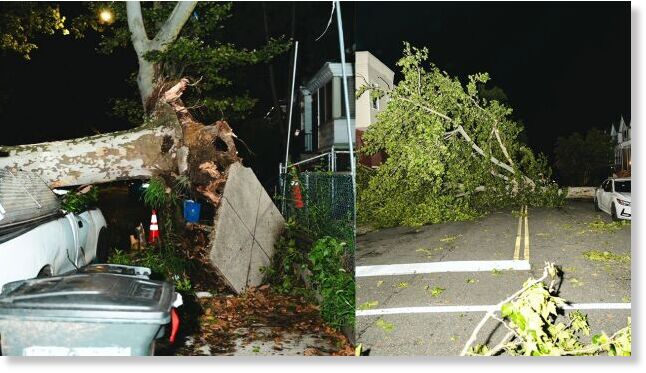
Powerful microbursts damage buildings, topple trees across Philadelphia, Pennsylvania

Damage from microbursts in Philadelphia, on July 11, 2026. The storm downed trees and caused damage to buildings across the city.
© Mayor Cherelle L. ParkerDamage from microbursts in Philadelphia, on July 11, 2026. The storm downed trees and caused damage to buildings across the city.
Cleanup crews fanned out across Philadelphia on Sunday after a series of powerful microbursts tore through the region, toppling trees, damaging buildings and blocking streets with massive trunks and branches.

The National Weather Service said at least four distinct microbursts struck a narrow corridor from southern Montgomery County into far eastern Delaware County, West Philadelphia and South Philadelphia on Saturday afternoon. The storms produced estimated wind gusts of 60-70 mph along a path about 12 miles long and 4-5 miles wide.

No fatalities or injuries were reported in the NWS damage survey, but destruction from the storm was widespread. The agency said dozens of reports of wind damage to trees and buildings were reviewed, along with radar data, photos and videos from during and after the storm. Investigators determined the damage was caused by severe microbursts and straight-line winds, not a tornado.


Volcano

Phivolcs records effusive eruption at Mayon Volcano, Philippines

mmmmm
The Philippines' Mayon volcano continued spewing lava and rocks in the early hours of Tuesday, the Philippine Institute of Volcanology and Seismology (Phivolcs) said.

The agency said the eruption has persisted for 190 consecutive days, producing lava flows, pyroclastic density currents and rockfalls.

A Level 3 alert remains in effect, which bars entry into the 6-kilometer Permanent Danger Zone. Phivolcs said the alert, in place since January 2026, indicates heightened volcanic unrest with magma close to the crater.

Authorities in Albay province continue enforcing the danger zone, while PHIVOLCS said it is monitoring the volcano around the clock.


Reuters

Lightning

Lightning strike kills 60 sheep, a dog and buffalo in Jammu Kashmir, India

mmmmm
A lightning strike in the early hours of Tuesday killed dozens of livestock and injured three members of a family in the Dhoke Kalkhata area of Ranjati in Surankote, Jammu and Kashmir's Poonch district, officials said.

Officials said the incident occurred in the higher reaches of Dhandidhara, where lightning struck an animal shed belonging to Shoket Hussain, son of Murad Baksh and a resident of Dhandidhara, presently residing at Dhoke Kalkhata, Ranjati.

The lightning strike killed 60 sheep, one buffalo and one dog on the spot, causing heavy losses to the family.

Three family members also sustained injuries and were administered first aid by the Indian Army.

No human fatalities were reported in the incident.

The administration has been informed, and an assessment of the damage is underway. (GNS)

Fireball 2

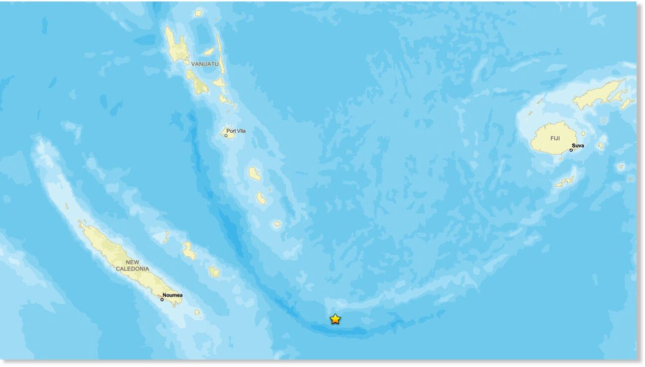
Shallow 6.3 magnitude earthquake strikes near New Caledonia in South Pacific

mmmmm
A 6.3 magnitude earthquake occurred near the Loyalty Islands in the French territory of New Caledonia in the South Pacific at approximately 1:45 a.m. local time on July 14, according to the United States Geological Survey (USGS).

The epicenter was located at 22.79 degrees south latitude and 171.52 degrees east longitude.

The depth of the earthquake was estimated at 10.0 km.

The waters near New Caledonia are part of the Ring of Fire, a region where the Pacific Plate and several continental plates meet, leading to frequent geological activity such as volcanic eruptions.

Tsunami

Typhoon Bavi brings heavy rain, triggers floods in northern and eastern China

Vehicles are swept away by flooding in Hebei Province.
© ReutersVehicles are swept away by flooding in Hebei Province.
Although downgraded to a tropical storm, it still brought heavy rainfall and triggered serious flooding in the country's northern and eastern provinces.

Read more about Typhoon Bavi: https://sc.mp/8471a5

After making landfall in eastern China on Sunday, Typhoon Bavi has made its way into northern China, where the storm has triggered heavy rainstorms and floods.


Comment: Also a day earlier in a central region of the country: Severe flash flooding in Sichuan, China: Cars and animals swept away - record-breaking rain of 8.8 inches in just 6 HOURS


Tsunami

Severe flash floods triggered by torrential rainfall hit northern Tajikistan

mmmmm
On July 11, 2026, catastrophic flash floods and mudflows devastated parts of northern Tajikistan, with Darg Village in the Ayni District of the Sughd Region being the hardest-hit area.

Triggered by torrential mountain rainfall, massive torrents of mud and rock swept through residential areas, carrying away vehicles, severing power lines, and destroying local roads and bridges.

Authorities have not yet released an official toll for casualties or injuries as emergency teams continue assessing the situation.


Doberman

Man dies after being attacked by his dog in New South Wales, Australia

MMMMMMMM
A man has died after he was attacked by his dog on his property in north-west NSW.

Emergency services responded to reports of a dog attack at a property on Timor Road in Coonabaraban at about 10am on Sunday.

Orana Mid Western Police District officers arrived and found a 55-year-old man suffering from serious injuries.

He was assessed by paramedics but died at the scene.

Police said the dog was euthanased by officers at the property.

A report will be prepared for the coroner.

Seismograph

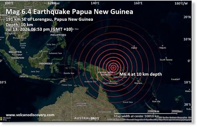
Shallow magnitude 6.4 quake strikes off Papua New Guinea

mmmmm
© Volcano Discovery
A magnitude 6.4 earthquake has struck offshore southeast of Lorengau, Manus Province, Papua New Guinea, according to the US Geological Survey (USGS).

There is currently no tsunami threat to Australia, Hawaii, or other Pacific regions. There are no immediate reports of damage or casualties. Authorities are continuing to monitor the situation.

There is an early discrepancy in reported magnitude. Some USGS-based reports initially listed M6.5, while later updates and other reports show M6.4, which is common as earthquake parameters are refined after the initial solution.