Earth ChangesS


Fish

Australian students discover rare fish dead on beach

Image
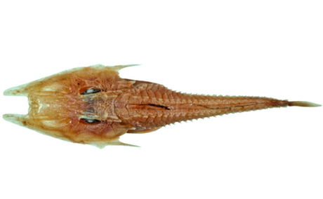
© Fishes of AustraliaLing's Armour Gurnard, Satyrichthys lingi.
Year 12 biology students from Coolum State High School have stumbled across an exciting find during a field study excursion at Peregian Beach.

The students found a Ling's armour gurnard (Satyrichthys lingi), a very rare fish native to Australian waters.

According to the Atlas of Living Australia, only seven Ling's armour gurnards have been reported found in Australia since 2000, and only two in the past four years.

"We were there to study the coastal dunes of Peregian Beach. Through data collection of different variables, including temperature, light intensity, pH of soils and wind strength, we analysed the adaptations of the coastal plants," teacher and head of department Paul Olsen said.

"Then, to find the Ling's armour gurnard was a real thrill, even though we were a little disappointed we found it deceased, washed up on shore. The Ling's Armour Gurnard lives on the sea floor, similar to a flathead fish. Most of the rare sightings are by divers and marine specialists, so we were very lucky to find it," he said.
Attention

Record-breaking cold in August for Northern Ireland

Image
Breaks record for the entire month of August.

A new record for the coldest August night was set on the night of 23rd/24th August for Northern Ireland.

The Met Office said temperatures plunged to a bone-chilling -1.9C (28.6F) at Katesbridge, Co Down, beating the previous record of -1.1C at Loughermore Forest in 1964.

Note: This wasn't just the coldest in Katesbridge, it was the coldest on record across all of Northern Ireland.

Thanks to Chris Beal, Sonya Porter, John McC and Caroline S for these links

Attention

Casualties of seafloor methane gas release? Hundreds of thousands more fish found dead in Plymouth tidal pool, UK

Image
Walkers found 'hundreds of thousands' of dead whitebait in the tidal pool at Devil's Point
Bebused walkers found "hundreds of thousands" of whitebait fish trapped in a tidal pool near Devil's Point yesterday.

It is the second time a shoal has been trapped in the same pool in less than two weeks.

Peter Wilkes and his fiance Carla Hosking were out enjoying a Sunday morning stroll with their 20-month-old son James when they thought they saw the pool at Firestone Bay looking as if it had "iced over".

On closer inspection, they found that it was the reflection of thousands of dead small dead fish which had become trapped in the shallow water.

"We saw the pond and it looked almost iced-over," said train-station worker Mr Wilkes.

Comment: Just a short distance away and around the same time as the above incident there came this report: Rare sei whale seen off Cornwall's coast in Penzance, UK

While across the Atlantic this happened: Rare 45-foot sei whale dies in Virginia river

In addition, another recent mass fish kill occurred back in the UK: Millions of dead herring wash up on Isle of Man coast, UK

One can't help but wonder if all these recent events are related and connected to this? Hundreds of methane plumes erupting along U.S. Atlantic coast


Alarm Clock

USGS: Earthquake Magnitude 6.0 - 6km NW of American Canyon, California

Earthquake 6.0 in N CA, USA
© USGS
Event Time
2014-08-24 10:20:44 UTC
2014-08-24 03:20:44 UTC-07:00 at epicenter

Location
38.220°N 122.313°W depth=11.3km (7.0mi)

Nearby Cities
6km (4mi) NW of American Canyon, California
8km (5mi) SSW of Napa, California
13km (8mi) NNW of Vallejo, California
14km (9mi) ESE of Sonoma, California
81km (50mi) WSW of Sacramento, California

Scientific data

Comment: There was a bigger earthquake later the same day in Peru, a 6.9.

Seems like the ring of fire is heating up!


Alarm Clock

USGS: Earthquake Magnitude 6.9 - 43km ENE of Tambo, Peru

Earthquake 6.9 tampo in Peru
© USGS
Event Time
2014-08-24 23:21:45 UTC
2014-08-24 18:21:45 UTC-05:00 at epicenter

Location
14.586°S 73.578°W depth=101.0km (62.8mi)

Nearby Cities
43km (27mi) ENE of Tambo, Peru
61km (38mi) ENE of Puquio, Peru
105km (65mi) S of Andahuaylas, Peru
129km (80mi) SW of Abancay, Peru
467km (290mi) SE of Lima, Peru

Scientific data

Eye 2

Snake sightings on the rise in New Mexico this year, including more venomous Mojave rattler

Image
© Erik EndersonMojave rattlesnake
The Mojave rattler, one of the most lethal rattlesnakes in the Southwest, has been gradually moving into new territory in Southeastern New Mexico.

The snake is a type of pit viper that has recently migrated from California and Arizona and appears physically similar to the area's native Western diamondback rattlesnake and black-tail rattlesnake. Mistaking the Mojave rattler for the other rattlesnakes could mean the difference between life and death according to some experts.

The Mojave rattler's fangs are infused with a neurotoxin that is much more potent than its diamondback counterpart, leading the New Mexico Game and Fish Department to dub it the "most dangerous of the state's rattlers." The snake has a reputation for being quick to strike and has venom nearly as toxic as a cobra according to a Game and Fish Department fact sheet on New Mexico rattlesnakes.

Rick Johnson, a Carlsbad resident, was surprised to have seen two dead baby Mojave rattlers since last week.

Sun

No end in sight: California's record drought is making Earth's surface rise

Image
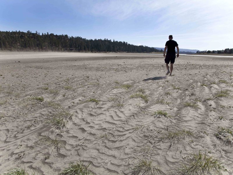
© Ruaridh Stewart/ZUMA Press/CorbisCalifornia’s exceptional drought has exposed the bottom of Big Bear Lake.
The record-breaking California drought is so bad that monitoring stations used to study earthquakes can detect the drying ground rising up. Measurements of these subtle movements, made using GPS instruments, suggest that the western United States is missing some 62 trillion gallons of water, enough to cover the entire region six inches deep.

Drought has plagued various parts of the western United States for years. California's dry times started at the beginning of 2013 and have continued to worsen. Nearly 100 percent of the state is now experiencing drought conditions, according to the U.S. Drought Monitor, and more than half the state falls under the most severe category of "exceptional drought." Water restrictions are in place. Farmers have been hard hit. And some people are even questioning participation in the viral "ice-bucket challenge" that is raising awareness and funding for amyotrophic lateral sclerosis (ALS).

While it's not difficult to see parched lawns and drying lakes, and scientists can directly measure changes in rainfall and stream flow, getting a measure of how much water has been lost from the desiccating landscape hasn't been easy. The new study, appearing today in the journal Science, provides a way to do just that by taking advantage of GPS monitors set up across the country.

Comment: Richard Howitt, professor emeritus of resource economics, stated:
"A well-managed basin is used like a reserve bank account," Howitt said. "We're acting like the super rich who have so much money they don't need to balance their checkbook."
The systems in which we live are failing in a fractal-like way. For those interested in the science behind these failures, from cosmic, to global, to you, check out:

Earth Changes and the Human-Cosmic Connection


Sun

California is sinking as aquifers disappear

Image
© USGSA pole is marked with the land levels in Mendota, California, showing the drastic sinking of the land for nearly a century.
Walk into any grocery store in America and there's a good chance the fresh produce you see there was grown in California. Up to half of the nation's fruit, nuts and vegetables are grown in the Central Valley, one of the planet's most fertile growing regions, between Los Angeles and Sacramento.

Now, for the first time this century, the entire state is in severe to exceptional drought.

"It's really depressing for us to leave ground out. We're still paying taxes and payments on everything that's non-production," said Gene Errotabere, whose family has farmed the valley since the late 1920s. "I mean, it's this whole valley. It's just a breadbasket of our whole country here, and to see this much ground being fallowed is not something I like to see."

Comment: What if it's not drought per se that is causing California to sink, but 'Earth opening up' from below that is causing aquifers to disappear?


Bizarro Earth

Small lava-eruption detected under Dyngju­jök­ull glacier, near Bárðarbunga

Bárðarbunga
© mbl.is/Á​rni Sæ­bergBárðarbunga
A small lava-erupti­on has been detected und­er the Dyngju­jök­ull glacier. Dyngju­jök­ull is a part Vatna­jök­ull, not far from Bárðarbunga.

The Icelandic Co­ast Guard airpla­ne TF-SIF is flying over the area with representati­ves from the Civil Protecti­on and experts from the Icelandic Met Offic and the Institu­te of Earth Sciences. Data from the equip­ment on bo­ard is expected later today.

Data from radars and webca­meras are being recei­ved, show­ing no signs of changes at the surface.

The estima­te is that 150-400 meters of ice is abo­ve the area.

The aviati­on col­or code for the Bárðarbunga volcano has been changed from orange to red.

Comment: See: Icelandic Bárðarbunga volcanic eruption begins


Snowflake

Bardarbunga eruption could trigger Britain's coldest winter ever this year

Britain could freeze in years of super-cold winters and miserable summers if the Bardarbunga volcano erupts, experts have warned
Image
© AP
Depending on the force of the explosion, minute particles thrust beyond the earth's atmosphere can trigger decades of chaotic weather patterns.

Tiny pieces of debris act as billions of shields reflecting the sun's light away from earth meaning winter temperatures could plunge lower than ever before while summer will be devoid of sunshine.The first effect could be a bitterly cold winter to arrive in weeks with thermometers plunging into minus figures and not rising long before next summer.

The Icelandic Met Office has this week warned of "strong indications of ongoing magma movement" around the volcano prompting them to raise the aviation warning to orange, the second highest and sparking fears the crater could blow at any moment.The region has also this week been hit by a magnitude-four earthquake - the strongest for almost 20 years, officials said.The British Met Office said the effects of an explosion on Britain's weather depends on the wind direction in the upper atmosphere. Spokeswoman Laura Young said: "If the upper winds are north-westerly it will have an effect on our weather."If the upper winds are westerly then it won't."

Comment: Gigantic Icelandic Volcano Could Plunge Europe Into Immediate Ice Age...