Earth ChangesS


Cloud Lightning

Wild weather: Rare lightning, hail strike Napa Valley in California

Napa Valley hail 1
One month after an earthquake struck the Napa area, the region was pounded by an incredibly rare hailstorm Friday afternoon. Heavy rainfall and lightning were also reported throughout the North Bay.

A viewer in the Napa County community of Browns Valley took video of hail covering the ground like snow.

KPIX 5 meteorologist Paul Deanno reported six inches of hail in the Napa area. Children were seen making snow angels and had snow fights with the hail.

"It was nothing but rain, then all of a sudden it comes down. It was complete hail for a good to 20 to 25 minutes," said Paul Frommelt of Napa. "In the 49 years I've lived here, I've never seen anything like this ever."

Ambulance

Seven dead in central China landslide after heavy rain

China landslide
© xuanen.gov.cnRescuers searching for survivors after a landslide hit a suburban community in Xuan'en County, central China's Hubei province on Saturday, September 27, 2014.
Seven people have been confirmed dead and another four were injured after a landslide buried several houses in a suburban community in central China's Hubei Province Saturday, local authorities said Sunday.

The landslide struck four houses in Xuan'en County of Enshi Tujia and Miao Autonomous Prefecture at about 6:10 a.m. Saturday. Local government confirmed that 11 people lived in one of the four houses while the rest three were unoccupied.

As of 9 p.m. Saturday, eight people have been rescued and rushed to hospital, but four of them died. The rest three were found dead early Sunday morning, said the rescue headquarters.

Cloud Lightning

More than 30 people believed dead at Japanese volcano

Image
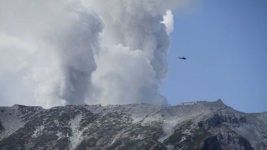
© AP Photo/Koji UedaSeptember 28, 2014: A military helicopter, aiding in rescue operations, flies above Mount Ontake as it continues to erupt in Nagano prefecture. Military helicopters plucked several people from the Japanese mountainside Sunday after a spectacular volcanic eruption sent officials scrambling to reach many more injured and stranded on the mountain.
The bodies of more than 30 people believed to be dead have reportedly been discovered near the summit of an erupting volcano in central Japan.

A police official from Nagano prefecture told the Associated Press that the victims were not breathing and their hearts had stopped, which is the the customary way for Japanese authorities to describe a body until police doctors can examine it. The official added that the exact location where the bodies were found and the identities of the victims were not immediately known. He spoke on condition of anonymity because he wasn't authorized to speak publicly.

Arrow Down

Car falls into monster 8-meter-wide sinkhole in Crimean road, 6 dead

Image
© RIA Novosti / Taras Litvinenko
Six people, including two children died after their car fell into a monster sinkhole in the middle of the highway near the Crimean capital of Simferopol. The hole appeared to be 6 meters deep and 8 meters wide.

The accident happened on the highway between Simferopol and the village of Nikolaevka on Saturday night, said the Emergencies Ministry's press service in Crimea. The car with eight passengers fell into the pit after the vehicle entered the unlit part of the road.

"A huge sinkhole six meters deep and eight meters wide was formed after the collapse," said the statement.

According to the medics, six passengers "received injuries incompatible with life." Among them were 3-year-old twins and a 16-year-old girl.

Comment: The sinkhole phenomena has roughly been in exponential growth the latest years and 'death by sinkhole' has been on the rise too. None of the usually invoked causes are able to explain the sudden rise of sinkholes in so many different locations, so in all probability, while considering the electric nature of our cosmic neighborhood and its link to seismic and meteorological change, the phenomena relates to a grander change in solar system conductivity. Consider how reduced solar activity may influence the spin of our globe and the stresses that may cause through changes in surface-core E-field, specifically the crust (Lithosphere).

Read more about the grander 'circuit board' of our electrochemical neighborhood, in:
Earth Changes and the Human-Cosmic Connection


Cloud Lightning

Ups and downs: 2013's natural disasters in review

earth changes
According to the "Annual Disaster Statistical Review 2013" published this month by the Centre for Research on the Epidemiology of Disasters (CRED), 2013 is a year with 330 registered natural disasters. This is less than the average annual disaster frequency observed from 2003 to 2012 which is 388, and represents a decrease in associated human impacts of disasters which were, in 2013, at their lowest level in last 16 years.

The death toll of natural disasters still killed a significant number of people totaling to 21,610 but this is largely below the annual average between 2003-2012 which is 106,654.

96.5 million people became victims worldwide, which was also below the 2003-2012 annual average of 216 million. On the side of the economy, economic damages from natural disasters shows, in 2013, a decrease to average levels, 2013 US$ 156.7billion, with estimates placing the costs at US$ 118.6 billion.
Image
Trends in occurrence and victims (deaths and affected)
For the last decade, China, the United States, Indonesia, the Philippines and India constitute together the top 5 countries that are most frequently hit by natural disasters.

In 2013, China experienced its highest number of natural disasters of the last decade. The country was affected by a variety of disaster types, including 17 floods and landslides, 15 storms, 7 earthquakes and one mass movement of geological origin, one drought and one period of extreme temperature.

Comment: In sum, 2013 saw fewer disasters, deaths, victims and economic damages on the whole. However, it saw isolated instances of record-breaking disasters, while floods and storms were responsible for the worst damage in terms of people affected. China and the U.S. continue to be hit the hardest, with China enduring its highest number of disasters in the last decade.

As Pierre Lescaudron describes in his book, Earth Changes and the Human-Cosmic Connection, this apparent decrease in disasters is probably due to an overall decrease in the Earth's electric field (due to a solar-companion-induced drop in the Sun's activity) and an increase in the conductivity of that field (due to the increase in comet dust entering our atmosphere). The result: more frequent, smaller storms (hurricanes, tornadoes, lightning, etc.). This will show up in the statistics as a drop in major natural disasters, but as we can see around us, it doesn't say much about the continued crazy weather the planet has been experiencing the last couple years.

It's the time for floods and storms to do their damage, while cosmically-induced processes perhaps build up for some future, major disasters. Think Chelyabinsk. Think Ebola.


Windsock

West Coast warming due to naturally occurring changes

Pacific Coast of North America
© www.publicdomainpictures.netPacific Coast of North America
Naturally occurring changes in winds, not human-caused climate change, are responsible for most of the warming on land and in the sea along the West Coast of North America over the last century, a study has found.

The analysis challenges assumptions that the buildup of greenhouse gases in the atmosphere has been a significant driver of the increase in temperatures observed over many decades in the ocean and along the coastline from Alaska to California.

Changes in ocean circulation as a result of weaker winds were the main cause of about 1 degree Fahrenheit of warming in the northeast Pacific Ocean and nearby coastal land between 1900 and 2012, according to the analysis of ocean and air temperatures over that time. The study, conducted by researchers from the National Oceanic and Atmospheric Administration and the University of Washington, was published Monday by the Proceedings of the National Academy of Sciences.

Natural, wind-driven climate patterns in the Pacific Ocean, such as El Niño and the Pacific Decadal Oscillation, are already known to exert a powerful influence on sea and land temperatures over years and even decades.

Comment: El Niño may be loosely defined as a build-up of unusually warm surface waters in the central and eastern equatorial Pacific Ocean that leads to global changes in temperature, wind patterns and precipitation. El Niños occur about every three to seven years. In between these events, trade winds blow across the Pacific from the east, creating a build-up of warm water in the western Pacific. After a period of time, some of this warm water starts to spread back across the Pacific, and the winds change as that happens. Some of the "temperature anomalies" reach eight degrees Fahrenheit above normal. There are greater odds of storms barreling into Southern California. Some of these storms would continue across the south, even to Florida. At the same time, the northern plains states could expect warmer and somewhat dryer conditions, while the Northeast and Canada may experience ice storms. El Niño greatly increases the risk of drought in Australia, increases the risk of wildfire in southeast Asia and Indonesia, would likely cause deluges and flooding in Peru and Ecuador and could lead to severe drought across parts of Africa.

The Pacific Decadal Oscillation is a calculation of monthly sea surface temperature over the North Pacific and is detected as warm or cool surface waters north of 20°N. During a warm or positive phase the west Pacific becomes cool and part of the eastern ocean warms. During a cool or negative phase, the opposite pattern occurs. It shifts phases about every 20-30 years. The PDO has been reconstructed to 1661 through tree-ring chronologies.

Underground volcanoes and methane releases also contribute to a warming trend in the Pacific Ocean.


Sun

Southern Canada, Montana, Wyoming, North Dakota baked in record heat

Image
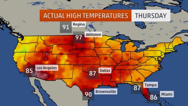
Actual high temperatures on Sept. 25, 2014.
When you think of 90-degree-plus record heat in late September, I'll bet Canada doesn't pop in your head first.

Contours of actual highs on Sept. 25, 2014 with record heat circled in Montana, North Dakota and southern Canada.

Highs Thursday soared into the 90s as far north as southern Saskatchewan and southern Manitoba, smashing daily temperature records.

Estevan, Saskatchewan topped out just under 94 degrees. The provincial capital of Regina had its warmest day of the year (91.6 degrees F or 33.1 degrees C). Eight other Canadian cities soared above 90 degrees in Saskatchewan and Manitoba.

Record highs were set as far north as Thompson, Manitoba (79.7F or 26.5C), just under 500 miles north of Winnipeg.

South of the border, both Williston, North Dakota, and Miles City, Montana (97), sweated through their record hottest day so late in the season, according to weather historian Christopher Burt and senior meteorologist Stu Ostro.

Rapid City, South Dakota (92), reached the 90s two weeks after their earliest snowfall on record.

Comment: Listen to a recent BlogTalkRadio discussion on earth changes and the recently released book by SOTT.net editors Pierre Lescaudron and Laura Knight-Jadczyk, Earth Changes and the Human-Cosmic Connection.

SOTT Talk Radio show #70: Earth changes in an electric universe: Is climate change really man-made? (With transcript)


Bizarro Earth

Upcoming weather pattern changes for the U.S. - Summer or Winter?

Image
Enjoy the warmth in parts of the Midwest and Northeast this weekend as a temperature shift is on the way. Parts of the northern Plains and southern Canada saw record hot temperatures so late in the season at the end of this past week. Williston, North Dakota and Miles City, Montana both saw the mercury soar to 97 degrees this past Thursday.

Record high temperatures are also in the forecast for parts of the Northeast through Sunday, where highs are expected to climb into the 80s.

Conversely, below-average temperatures will be found in much of the West through this weekend. Changes, however, are on the way heading towards next weekend. There are indications that an upper-atmospheric trough will build into the East, while an upper-atmospheric ridge builds into the West. The past few days we have had a ridge in the East and a trough in the West.

Forecast Highs and Departure from Average

This pattern change will bring temperatures that are 20-30 degrees colder for some locations from the northern Plains. Temperatures will also be cooler in parts of the Midwest and Northeast, where highs will go from the 70s and 80s this weekend, to the 50s and 60s next weekend.

As it cools down in the East, the warmth will make a comeback along the West coast, with highs 15-20 degrees warmer by next weekend. Los Angeles will go from highs in the 70s to highs in the 90s and average high temperatures for early October should be in the low 80s.

Cloud Lightning

More Phoenix flooding: Odd Monsoon-like weather hits

Image
© AP Photo/The Arizona Republic, Jeffrey LowmanVehicles drive through the flood prone area of 39th Avenue between Peoria Avenue and Cactus Road during a storm in Phoenix on Saturday, Sept. 27, 2014. National Weather Service meteorologist Marvin Percha says the weather is a mix of Phoenix's first fall storm and leftover monsoon moisture.
Intense storms swept through the Southwest on Saturday, snapping trees and shrouding metropolitan Phoenix in cascading showers while also bringing flooding to parts of Nevada.

The skies above downtown Phoenix were completely gray in the afternoon as strong winds, thunder and rain hit the region. The outside visibility of buildings was almost entirely obscured by rain and clouds.

The storm forced authorities to close a section of Interstate 17 for more than hour due to flooding. Flight departures and landings resumed about 3:30 p.m. after they were halted for an hour at Phoenix Sky Harbor International Airport. But airport spokeswoman Julie Rodriguez said delays are expected into the evening. More than 40 flights scheduled to land in Phoenix were diverted to other airports, she said.

"The wind caused some damage to the roof of Terminal 2 in the baggage claim area and in some of the gate areas. However, all three terminals at Sky Harbor are operational," Rodriguez said in a statement.

Cloud Precipitation

Tropical Storm Rachel upgraded to Hurricane Rachel

Image
© NOAA
NHC has upgraded Tropical Storm Rachel to a hurricane - the twelfth hurricane of this active 2014 eastern North Pacific hurricane season. Maximum sustained winds are 75 mph - a Category 1 hurricane on the Saffir-Simpson Hurricane Wind Scale. Little change in strength is expected tonight, with weakening forecast to begin on Sunday.

Rachel is centered about 460 miles west-southwest of the southern tip of the Baja California peninsula, moving toward the north-northwest. There are no coastal watches or warnings in effect.

Get the latest on this tropical cyclone tonight by visiting the NHC website.
Image
© NOAA