Earth ChangesS

Cloud Lightning

Boat capsizes off western Burma during cyclone Mahasen evacuation, many feared drowned

Sittwe
© Human Rights Watch/AFP/Getty Images The site of a destroyed mosque in April after ethnic violence in Sittwe: at least 192 people were killed in June and October last year in violence in Rakhine state.
Many feared drowned as boat carrying Rohingya Muslims hits rocks during evacuation ahead of cyclone Mahasen

A boat carrying about 100 Rohingya Muslims has capsized off western Burma with many feared drowned at the start of a mass evacuation from low-lying regions ahead of cyclone Mahasen, a UN official said on Tuesday.

The boat struck rocks off Pauktaw township in Rakhine state and sank late on Monday, Barbara Manzi, head of the Burma office at the UN Office for the Co-ordination of Humanitarian Affairs (OCHA), told Reuters.

She said an unknown number of people were missing.

The UN warned last week that the tropical cyclone could bring "life-threatening conditions" to thousands of people living in camps in the west of Burma after their homes were destroyed in violence between majority Buddhists and minority Muslims last year.

Blue Planet

Seabird bones reveal changes in open-ocean food chain

Remains of endangered Hawaiian petrels -- both ancient and modern -- show how drastically today's open seas fish menu has changed.

Image
© Courtesy of Brittany Hance, Imaging Lab, Smithsonian InstitutionExcavated bones of Hawaiian petrels โ€“ birds that spend the majority of their lives foraging the Pacific โ€“ show substantial change in the birds' eating habits.
A research team, led by Michigan State University and Smithsonian Institution scientists, analyzed the bones of Hawaiian petrels -- birds that spend the majority of their lives foraging the open waters of the Pacific. They found that the substantial change in petrels' eating habits, eating prey that are lower rather than higher in the food chain, coincides with the growth of industrialized fishing.

The birds' dramatic shift in diet, shown in the current issue of the Proceedings of the National Academy of Sciences, leaves scientists pondering the fate of petrels as well as wondering how many other species face similar challenges.

"Our bone record is alarming because it suggests that open-ocean food webs are changing on a large scale due to human influence," said Peggy Ostrom, co-author and MSU zoologist. "Our study is among the first to address one of the great mysteries of biological oceanography -- whether fishing has gone beyond an influence on targeted species to affect nontarget species and potentially, entire food webs in the open ocean."

Hawaiian petrels' diet is recorded in the chemistry of their bones. By studying the bones' ratio of nitrogen-15 and nitrogen-14 isotopes, researchers can tell at what level in the food chain the birds are feasting; generally, the larger the isotope ratio, the bigger the prey (fish, squid and crustaceans).

Between 4,000 and 100 years ago, petrels had high isotope ratios, indicating they ate bigger prey. After the onset of industrial fishing, which began extending past the continental shelves around 1950, the isotope ratios declined, indicating a species-wide shift to a diet of smaller fish and other prey.

Much research has focused on the impact of fishing near the coasts. In contrast, the open ocean covers nearly half of Earth's surface. But due to a lack of historical records, fishing's impact on most open-ocean animal populations is completely unknown, said lead author Anne Wiley, formerly an MSU doctoral student and now a Smithsonian postdoctoral researcher.

Bizarro Earth

Mexico's giant Popocatepetl volcano simmering towards a large eruption?

Mexico's giant Popocatepetl volcano may generate lava flows, explosions of "growing intensity" and ash that could reach miles away, the National Center for Disaster Prevention said Monday. Officials were preparing evacuation routes and shelters for thousands of people who live in the shadow of Popocatepetl, located 40 miles southeast of Mexico City. Officials have created a 7.5-mile restricted zone around the cone of the volcano. Popo, as the volcano is known, has displayed a "notable increase in activity levels" in the last few days, including tremors and explosive eruptions, according to a statement from the federal government. The 17,887-foot volcano has been disgorging large towers of steam and ash since mid-April, but officials have become more concerned in recent days as activity has intensified. Webcams have shown large chunks of molten rock spewing from the crater, and ash has rained down on the nearby city of Puebla. On Sunday, the National Center for Disaster Prevention elevated its warning level to Yellow Phase 3, the fifth stage of a seven-stage warning scale.
Image
© Marco Ugarte, Associated PressThe Popocatepetl volcano spews ash and steam as seen from Santiago Xalitzintla, Mexico, on Sunday evening.
At the next stage, Red Phase 1, a voluntary evacuation order would be issued for residents of nearby villages. Then, in a familiar ritual, bells would ring in town squares, residents would gather with their identification papers in plastic bags, and police and soldiers would offer to move them to safety. Popocatepetl, which means "smoking mountain" in the Aztec language Nahuatl, dominates much of the landscape in central Mexico, along with its nearby "twin" volcano, the dormant Iztaccihuatl. Popo was dormant for decades until 1994, when it began to stir. There have been moderate outbursts from Popo in recent years, forcing the government to evacuate as many as 75,000 people at a time. The government for the state of Puebla has already sent hundreds of police to three of the most vulnerable villages, where 11,000 people could be affected. Shelters have been set up and stocked with food, water and clothes. We're ready for any emergency," said Lidia Carrillo, a spokeswoman for the state.

Bizarro Earth

Alaska's Mt. Pavlof volcano is 'very, very hot'

Image
Another volcano in Alaska is heating up, with seismic instruments signaling a possible eruption. The Alaska Volcano Observatory says tremors were detected Monday at Pavlof Volcano 1,000 km southwest of Anchorage. John Power, the US Geological Survey scientist in charge at the observatory, said satellite imagery shows the volcano is "very, very hot." Pavlof is 60km from the community of Cold Bay. The volcano last erupted in 2007. It's the second Alaska volcano to rumble this month. Cleveland Volcano, on an uninhabited island in the Aleutian Islands, experienced a low-level eruption in early May. Power said satellite imagery shows the volcano continues to discharge steam, gas and heat, although no ash clouds have been detected in the past week. Cleveland is not monitored with seismic instruments. - News 24

Blackbox

Megacryometeor? Giant ice meteor slams to Earth near kids playing in Tennessee

A Tri-Cities man has video of what appears to be a large chunk of ice that he says fell from the sky on Wednesday (May 8) and landed in a yard in Gray, TN. Andy Miller says his children were playing outside along Keeview Drive off Hales Chapel Road around 4 p.m. when they heard what sounded like a rocket. "They ran into the house shaking," Miller said. He used his phone to record video of the children inspecting the pile of pure white ice sitting in a gouged out hole in the ground near where they were playing. Miller did a quick web search and found information that lead him to believe it's a megacryometeor. For what it's worth, here's a quick definition we found on line: "A megacryometeor is a very large chunk of ice which, despite sharing many textural, hydro-chemical and isotopic features detected in large hailstones, is formed under unusual atmospheric conditions which clearly differ from those of the cumulonimbus cloud scenario (i.e. clear-sky conditions). They are sometimes called huge hailstones, but do not need to form in thunderstorms." -WBTW


Sun

Sun unleashes three powerful X-class flares within 24 hour period

Image
The sun erupted for the second time in less than 24 hours Monday morning, releasing the most powerful solar flare so far of 2013. Monday's solar flare, which peaked at 9 a.m. Pacific time, came just 14 hours after the second largest solar flare of 2013, which occurred on Sunday evening. A solar flare is a huge explosion in the sun's atmosphere that sends out a burst of radiation. The Earth's atmosphere protects us from that radiation, but some satellites could be affected. Monday's solar flare is classified as an X2.8, according to NASA. Sunday's solar flare was an X1.7. In the language of solar flare watchers, an X class solar flare is the largest type of solar flare. An X2 is twice as powerful as an X1, and an X3 is three times as powerful, etc. The Sunday solar flare was the first X-class solar flare of 2013. Both solar flares originated from sunspots that are just hidden from view on the left-hand side of the sun.

Heart - Black

Wildlife officers kill four mountain lions in Black Hills, South Dakota

Image
State wildlife officers killed three mountain lions that had confronted dogs, strolled through yards and killed deer on city streets in the southwestern South Dakota community of Keystone.

Game, Fish and Parks officers killed an adult female lion and two 40-pound kittens on May 5 and May 6.

Regional wildlife manager John Kanta says Keystone is in the middle of lion habitat, and officials gave the lion a chance to move its kittens out of the city. But he says the mother lion didn't cooperate.

Officers also killed a male lion at Angostura State Recreation Area near Hot Springs on May 6 because it was hanging out near a recreational trail, watching hikers and bikers.

Info

Dead dolphins washed ashore in Batumi, Georgia


Two dead dolphins were washed ashore by the sea in Batumi on May 8. The one meter-long sea pig dolphins were later found to have died as a result of the morbillivirus epidemi, Rustavi 2 channel reports. Head of the Flora and Fauna Association Archil Guchmanidze said ten cases of the sea washing dead dolphins ashore had been recorded this year on shores in Georgia.

Info

Woman bitten by rabid fox in Laurinburg, NC

Image
Health officials have confirmed that the fox that attacked a Scotland County woman earlier this week had rabies.

The fox tried to bite the woman early Wednesday morning as she walked to her car. The incident occurred in the Leisure Living subdivision off Havelock Drive in Laurinburg.

County health officials did not name the victim, but said that state officials confirmed that the fox had been rabid. It is the first case of rabies in the county this year.

Ashley Cayton said she was headed out to work when she saw what she thought was a dog at the end of her driveway.

"I didn't pay any attention to it," said the 26-year-old Cayton, who works as a newspaper carrier for The Laurinburg Exchange. "The next thing I knew, the animal had grabbed me by the leg and ripped a hole in my jeans trying to bite me."

Cayton said she tried to shake the fox off her leg and finally got away by slamming her leg against the side of her vehicle.

"Once I got it off me, I jumped in my car and called my boyfriend and told him that I had been bitten," Cayton said. "I told him not to come outside, but he didn't listen. He thought it was a dog, but I was pretty sure that it wasn't."

Cayton said her boyfriend, who was armed with a baseball bat, whistled for the animal.

"Nothing happened the first time, but after a second whistle, the fox came out from in front of the car and went after him," Cayton said. "When the fox got close enough, my boyfriend hit it hard and killed him."

Cayton said that the fox "had only grazed her skin", but she immediately went to the hospital to begin rabies treatments. The couple also brought the body of the fox to the hospital so the animal could be tested by the state.

State health officials alerted Cayton and county health officials on Thursday that the fox was suffering from rabies.

Bizarro Earth

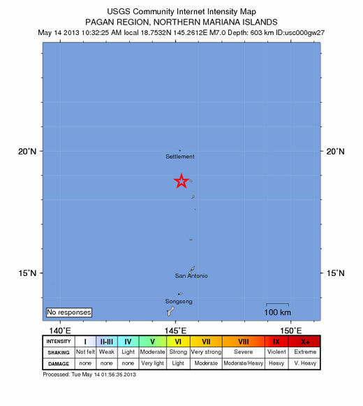
USGS: Earthquake Magnitude 7.0 - W of Agrihan, Northern Mariana Islands

Agrihan Quake_140513
© USGS
Event Time
2013-05-14 00:32:25 UTC
2013-05-14 10:32:25 UTC+10:00 at epicenter

Location
18.753ยฐN 145.261ยฐE depth=603.4km (374.9mi)

Nearby Cities
42km (26mi) W of Agrihan, Northern Mariana Islands
395km (245mi) N of Northern Islands Municipality - Mayor's Office, Northern Mariana Islands
395km (245mi) N of Saipan, Northern Mariana Islands
420km (261mi) N of JP Tinian Town pre-WW2, Northern Mariana Islands
578km (359mi) N of Yigo Village, Guam

Technical Details