Earth ChangesS


Bizarro Earth

Alert Level Raised for Sotará Volcano in Columbia

Sotarà Volcano
© INGEOMINASThe summit of Sotarà volcano on an INGEOMINAS photo from Oct 2011.
The recent increase in seismic activity under Sotarà volcano prompted INGEOMINAS to raise the alert level from yellow (unrest) to orange (eruption warning) yesterday afternoon.

The increase had been detected on June 24, 2012 and since that date, 6891 earthquakes have been recorded, i.e. an average of 150 quakes per day. Most of them (5177) are of very small magnitude, but the remaining 1714 quakes were of significant energy (local magnitudes 0.1-2.2) and concentrated in an area between 0.1 and 5 km northeast of the volcanic summit at depths between 2 and 6 km.

None of these events were felt by inhabitants of the communities surrounding the volcano Sotará.

The deformation network shows a possible inflation process towards the northeast sector of the volcano, which correlates with the epicentral zone of seismicity reported and suggest that magma is rising there, and might (or might not) lead to an eruption in a near to medium future.

During the month of July, geochemical surveys showed no significant changes in temperatures of hot springs in the area.

INGEOMINAS stresses that this activity does not pose any immediate danger to the communities aroud the volcano. However, it should be said as well that this could change quickly.

Bizarro Earth

Source of Mysterious Pumice 'Raft' in Pacific Found, NASA Says

Floating Island
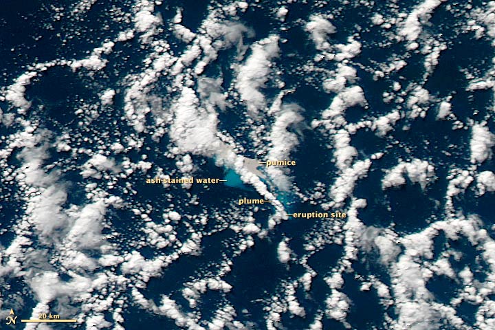
© Jeff Schmaltz, LANCE MODIS Rapid Response Team at NASA GSFCTaken in the afternoon on July 19, 2012, this NASA MODIS image reveals the Havre Seamount eruption, including the gray pumice, ash-stained water and the volcanic plume.
The source of an enormous floating mass of pumice spotted this week in the South Pacific Ocean off the coast of New Zealand has been discovered: NASA satellite images and other sleuthing science have pinpointed an erupting undersea volcano called the Havre Seamount as the culprit.

On Aug. 9, the HMNZS Canterbury ship observed the floating pumice "island" - measuring a whopping 300 miles (482 kilometers) in length and more than 30 miles (48 km) wide - along a voyage from Auckland to Raoul Island, New Zealand. A maritime patrol aircraft, RNZAF Orion, had seen the weird mass and reported it to this Royal New Zealand Air Force ship. Soon after, the HMNZS crew saw the thick mass of porous rocks.

"The rock looked to be sitting two feet above the surface of the waves, and lit up a brilliant white colour in the spotlight. It looked exactly like the edge of an ice shelf," said Lieutenant Tim Oscar, a Royal Australian Navy officer, in a statement.

Pumice, which forms when volcanic lava cools quickly, is riveted with pores due to gas getting trapped inside as the lava hardens. The result: lightweight rocks that can therefore float. (Recent research suggests such pumice replenishes the Great Barrier Reef with new coral.)

Where the huge floating mass came from was a mystery. At the time, according to the Royal Navy, scientists thought an underwater volcano, possibly the Monowai seamount, which has been erupting along the so-called Kermadec arc, was responsible. [See Photos of the Pumice Raft]

Bizarro Earth

False reports of California earthquakes are caused by Russian 7.7 Magnitude Earthquake

Image
© USGS
A magnitude 7.7 earthquake in a sea off the coast of eastern Russia did not cause any reported damage or injuries.

But it did cause numerous "false positive" reports of earthquakes in California, a U.S. Geological Survey official said Monday night.

The temblor struck Monday night PDT (1 p.m. local time) under the Sea of Okhotsk. Officials said it was 373 miles below ground and did not result in any tsunamis.

But for reasons that are not entirely clear, it triggered several erroneous reports of quakes in California.

Leslie Gordon, USGS spokeswoman in Menlo Park, said the false reports of earthquakes in Gerber, the Monterey area and Gilroy were triggered by the Russian quake. Those reports were retracted within minutes, Gordon said. A couple of the reports were erroneously reissued, then retracted again.

False reports occasionally are registered by USGS automatic earthquake sensors, she said.

Bizarro Earth

Nearly 1,000 earthquakes recorded in Arizona over 3 years

Image
© Incorporated Research Institutions for Seismology (funded by NSF EarthScope)Nearly 60 USArray stations were installed in Arizona from 2006 to 2009 as part of the EarthScope project. Station 118A, seen in this photo, recorded ground motion north of Wilcox in southeastern Arizona from April 6, 2007 to Jan. 21, 2009.
Earthquakes are among the most destructive and common of geologic phenomena. Several million earthquakes are estimated to occur worldwide each year (the vast majority are too small to feel, but their motions can be measured by arrays of seismometers). Historically, most of Arizona has experienced low levels of recorded seismicity, with infrequent moderate and large earthquakes in the state. Comprehensive analyses of seismicity within Arizona have not been previously possible due to a lack of seismic stations in most regions, contributing to the perception that widespread earthquakes in Arizona are rare.

Debunking that myth, a new study published by Arizona State University researchers found nearly 1,000 earthquakes rattling the state over a three-year period. Jeffrey Lockridge, a graduate student in ASU's School of Earth and Space Exploration and the project's lead researcher, used new seismic data collected as part of the EarthScope project to develop methods to detect and locate small-magnitude earthquakes across the entire state of Arizona. EarthScope's USArray Transportable Array was deployed within Arizona from April 2006 to March 2009 and provided the first opportunity to examine seismicity on a statewide scale. Its increased sensitivity allowed Lockridge to find almost 1,000 earthquakes during the three-year period, including many in regions of Arizona that were previously thought to be seismically inactive.

"It is significant that we found events in areas where none had been detected before, but not necessarily surprising given the fact that many parts of the state had never been sampled by seismometers prior to the deployment of the EarthScope USArray," says Lockridge. "I expected to find some earthquakes outside of north-central Arizona, where the most and largest events had previously been recorded, just not quite so many in other areas of the state."

Cow Skull

Mysterious disease kills 68 cattle in Cholistan, Pakistan

A mysterious disease has killed 68 cows during the last week in Cholistan, a private TV channel reported on Monday.

According to Geo News, the disease, which starts with a light fever that leads to fits in the cattle leading to their death, had killed several dozen animals over the last week.

The channel, citing local residents, said that due to a drought this year, the animals were being forced to drink dirty water. Zoology expert Ali Raza said that dirty water was causing stomach and liver diseases.

Meanwhile, the managing director of the Cholistan Development Authority said that a committee had been formed to investigate the death of the cattle.

Blackbox

Mysterious Louisiana Sinkhole Raises Concerns of Explosions and Radiation

Image
A nearly 400-foot deep sinkhole in Louisiana has swallowed all of the trees in its area and enacted a mandatory evacuation order for about 150 residences for fear of potential radiation and explosions.

The 400-square-foot gaping hole is in Assumption Parish, La., about 50 miles south of Baton Rouge.

The sinkhole sits in the middle of a heavily wooded space where it has consumed all of the soaring cypress trees that had been there. Flyover photos show some of the treetops still visible through the mud.

Authorities enacted a mandatory evacuation for between 100 and150 homes in the area, but most people have chosen to stay, according to the Mayor's Office of Emergency Preparedness. If any of the dangers seem to become more imminent, the order will be escalated to a forced evacuation.

Bizarro Earth

Tofua volcano erupts, sending ash cloud 3,000 feet above Tonga Islands

Image
A "new" volcano just entered the watch list: Out in the Pacific, a pilot observed an ash cloud rising from Tofua volcano to 3,000 ft (ca. 1 km) in the Tonga Islands at 04:42 GMT, VAAC Wellington reports. The volcano last erupted in 2009. - Volcano Discovery.

Historical background: Tofua Caldera, in Tonga, is the summit caldera of a steep-sided composite cone that forms Tofua Island. Tofua Island is in Tonga's Ha'apai island group. Pre-caldera activity is recorded by a sequence of pyroclastic deposits and lavas constituting the older cone, followed on the northern part of the island by froth lavas or welded and unwelded ignimbrite.

Bizarro Earth

Wildfires threaten homes in several western states

Wildfires have destroyed dozens of homes and threatened hundreds more in several western U.S. states, including Idaho, where an on-duty firefighter was killed by a falling tree. Anne Veseth, a 20-year-old who was in her second season as a firefighter, was killed Sunday as she worked a fire near Orofino, the U.S. Forest Service said. Her older brother also is a wild-land firefighter in Idaho, where 12 blazes are burning.

"The Forest Service is devastated by the loss of one of our own," Forest Supervisor Rick Brazell said.Officials were investigating the death, which came on the same day that another firefighter narrowly escaped a wildfire in southeastern Oregon.

That firefighter was forced to deploy her emergency shelter in an area overrun by wind-whipped flames. She suffered minor burns to a leg and forearm and minor smoke inhalation. Her 20-person federal crew made it to a safety zone and was pulled off the fire. The blaze scorched about 653 square miles in remote terrain straddling Oregon and Nevada, where five ranches in the Kings River Valley were evacuated.


Bizarro Earth

Unusual weather events identified during the Black Saturday bushfires

Image
Research has revealed that the extremely hot, dry and windy conditions on Black Saturday combined with structures in the atmosphere called 'horizontal convective rolls' -similar to streamers of wind flowing through the air - which likely affected fire behaviour. The study is the first of its kind to produce such detailed, high-resolution simulations of weather patterns on the day and provides insights for future fire management and warning systems.

The work was led by Dr Todd Lane and Ms Chermelle Engel from The University of Melbourne with Prof Michael Reeder (Monash University) and Dr Michael Rezny (ARC Centre of Excellence for Climate System Science).

The team examined meteorological conditions across Victoria on 7 February, 2009. The analysis used a very high-resolution weather forecasting model, which represented the airflow over the entire state on 400 metre weather grids, which are about ten times smaller than the grids used in operational weather forecasting. Weather conditions observed on the day were used to validate the model.

Cloud Lightning

New storm threatens flood-hit Philippines

Image
Philippine authorities warned Monday an intensifying storm could bring more misery to the flood-battered capital and surrounding areas, where nearly half a million were in evacuation centres.

While flooding that covered 80 percent of Manila last week had largely subsided, vast areas of mainly rice-growing provinces to the north were still under water that in some places remained neck-deep.

Most of the 411,000 people crammed into gymnasiums, schools and other government evacuation centres were in the flooded farming provinces, with many others struggling by living in partly submerged homes.