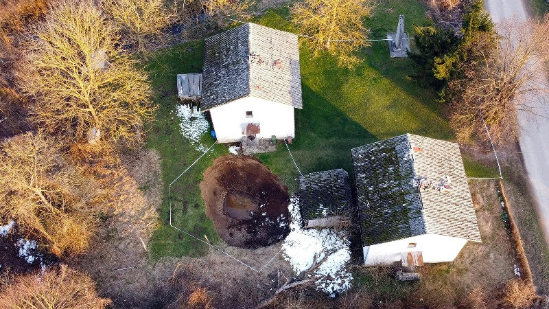
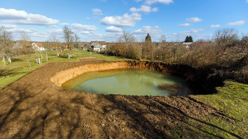
It happened suddenly and without warning. Where there should have been the emerging first shoots of potato seedlings behind the orchard in Nikola Borojević's spacious garden, there was now huge hole. Measuring 30m (98ft) wide and 15m (49ft) deep, it quickly filled with water. And it wasn't the only one.
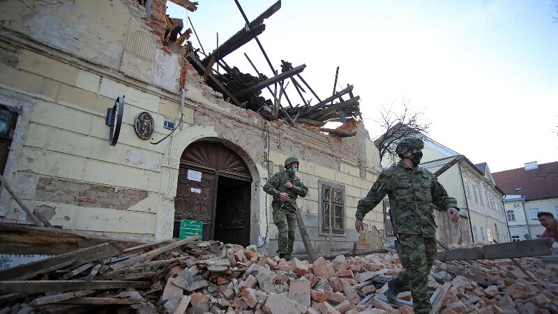
Within the space of a few weeks, dozens of similar holes had opened up around the village of Mečenčani and neighbouring Borojovići in north-east Croatia. The one outside Borojević's home in Mečenčani appeared on 5 January, just six days after a 6.4 magnitude earthquake struck the area around the nearby city of Petrinja. It was the strongest earthquake to have hit Croatia for more than four decades, killing seven people and destroying thousands of homes.
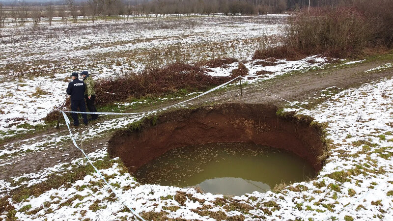
While landslides and sinkholes are known to be triggered by earthquakes, along with other strange geological phenomena such as liquefactions - where the solid ground begins to behave like a liquid - the sheer number of holes appearing around the two villages surprised and baffled experts. A month after the earthquake, there were almost 100 sinkholes spread over a 10 sq km (3.8 sq miles) area, with new ones opening every week.
The hole in Borojević's garden is now the largest in the area. When it first appeared it was 10m (33ft) wide, but started to grow almost immediately.
"My wife was in the house the whole morning, looking occasionally through the window," says Borojević. "Around 2pm she noticed something strange in the garden. We went outside and there was this huge hole in our orchard." Over the following three months, the hole tripled in size.
But the Borojevićs were lucky. Other sinkholes in the area opened up just a few metres from the doorsteps of people's homes and one appeared beneath a house, prompting officials to consider evacuating both villages. Others appeared in the surrounding woods and agricultural fields, where one of them, according to some local rumours, almost swallowed the local farmer and his tractor.
"Nobody expected the appearance of so many sinkholes," says seismologist Josip Stipčević from the Department of geophysics at the Faculty of Science in Zagreb.
Croatia sits on a highly seismically active area, where the small Adriatic plate is colliding with the Eurasian tectonic plate, causing a number of active faults, explains Stipčević. Before the earthquake on 29 December 2020, the country had experienced nine others with a magnitude over 6 since the beginning of the 20th Century. The last major earthquake to have occurred on the Pokupsko-Petrinja fault - along which the most recent one occurred - was in 1909.
The 1909 earthquake occurred only 23km north west from the epicentre of the one that shook at the end of 2020. That too attracted the attention of leading seismologists at the time. The famous Croatian geophysicist Andrija Mohorovičić studied seismographs from the 1909 Pokupsko earthquake and concluded that seismic waves travel with different speeds as they pass through different layers of the Earth. His insight led to the discovery of a boundary that separates Earth's crust from its mantle, known today as the Mohorovicic discontinuity, or simply the Moho.
Today, researchers are studying the same area in the hope of understanding how the earthquake led to so many holes suddenly appearing.The real anomaly in Croatia's case is a very high number of sinkholes with significant dimension - Antonio Santo
Sinkholes are not the most common consequence of powerful seismic shocks but they do occur, especially in the areas with hidden underground cavities. After the devastating earthquake near the Italian city L'Aquila in 2009, two sinkholes immediately opened on roads in the old part of the city. Experts at the time suspected that a previous excavation of vertical trenches for a sewage conduit weakened the conglomerate roof of the underground cave, contributing to the collapse.
"The real anomaly in Croatia's case is a very high number of sinkholes with significant dimension," says Italian geologist Antonio Santo at University of Naples Federico II.
Croatia's village of holes
The deep and wide holes endangering the two Croatian villages are known as cover-collapse sinkholes. They usually appear in areas where the underground rock has been hollowed out to form cavities and caves by water and is covered with a thick layer of soil, sand or alluvium, and most importantly, clay.
Over time, the water slowly washes surface material from its deeper layers into the cavernous underground. If there was only sandy soil, this process could be eventually spotted on the surface. But the presence of clay makes this surface material more sturdy and consistent, so after a while, a void is formed in the soil from below, but is almost undetectable above ground. As the surface layer became structurally weaker, it eventually collapsed into the void below.
Usually this process happens over a long period of time, but can be accelerated by intensive rainfall, flooding or even human activity like mining or aggressive groundwater pumping.
First, although the coastal part of Croatia belongs to the world-famous Dinaric karst, home to thousands of deep limestone caves and hundreds endemic cave-species, underground limestone formations also stretch inland beneath central Croatia. The limestone that forms cavernous rock in this boundary area between the Dinaric karst and Pannonian basin was deposited in the Miocene period when this area was underwater and connected to what is now the Mediterranean sea.
"While Dinaric karst is mostly from the Cretaceous and Jurassic period, the karst that we find here is younger and even more porous and hollow," says Josip Terzić, a hydrogeologist from the Croatian Geological Survey. "It is limited to a few small zones around here and close to the city of Zagreb."
When the Pannonian basin became disconnected from the Mediterranean due to the shifting landmasses some 11 million years ago, it became a massive lake. Rivers slowly filled it with silt, sand and gravel to form the present-day vast lowlands. Consequently, around 10-15m of soil, stones and clay lay on top of the porous rock beneath the villages of Mečenčani and Borojevići.
The danger, though, was hard to detect. Some sporadic sinkholes appeared before, but according to locals, very rarely.
"It is obvious that earthquakes accelerated some already on-going processes," says Terzić. In fact, the first discovered sinkhole started to open after a magnitude 5 foreshock struck the area the day before the larger one. As the stronger earthquake and the accompanying aftershocks shook the area, it caused the ground to shift by more than 30cm (12 inches). This displacement destabilised the precarious situation.
"The earthquakes caused massive dynamic stress to these lands and locations that were already in borderline balance suddenly collapsed," says Terzić.One recent report from scientists at the University of Zagreb warns that irrigation systems in the Mečenčani and Borojevići area probably accelerated the karstification process
His colleague, Bruno Tomljenović, a geophysicist at Zagreb University believes that the earthquakes disrupted the movement of water underground, sending it shooting upwards towards the surface, and moving from areas of high pressure to lower pressure. This increased hydrodynamics in underground passages accelerated collapsing of surface material, explains Tomljenović.
"Also, there is a chance that a few collapsed sinkholes caused additional changes in hydrodynamics, with water searching for new passages and possibly causing more sinkholes," says Tomljenović. An unusually large number of shocks also may have contributed to so many collapses at the same time, says geologist George Veni, director of The National Cave and Karst Research Institute in New Mexico, an area also know for sinkhole problems, often caused by activities connected to industrial wells. Human influence also increases the rate at which cover-collapse sinkholes form, warns Veni.
One recent report from scientists at the University of Zagreb warns that irrigation systems built in the Mečenčani and Borojevići area probably accelerated the karstification process.
For the time being scientists don't have enough data to analyse the connection between the strength and number of earthquakes with the appearance of sinkholes.
But predicting where sinkholes like this may open up is far from easy, says geologist Mario Parise an experts on hazards in karst environments at the University Aldo Moro in Bari, Italy.
"We can so far just rely on the historical data and documents to know areas that are most susceptible to this type of processes," he says. Although some sinkhole hazard models have been proposed in the last decade, "developing a warning system for sinkholes is a field where much work needs to be done", he adds.
For Tomljenović, one of the lessons from the Croatian sinkholes is the need for more intensive seismic microzonation in order to detect areas within the populated areas that are especially vulnerable to dangerous earthquake consequences. He and his colleagues are attempting to do this using electrical resistivity tomography and seismic refraction surveying in the Mečenčani and Borojevići area, in the hope of identifying locations that are safe from sinkholes and those that are still prone to them.
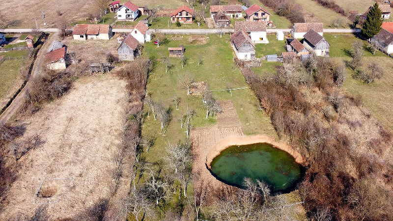
In the meantime, the massive hole filled with water still stands in Borojević's garden and has even become a local tourist attraction. Six months after the earthquake, efforts to fill in the sinkholes should begin soon.
"It's also a tricky business," says geotechnician Davor Ljubičić who is coordinating geotechnical working group at the civil protection crisis unit. "Very near these two villages is the communal water supply source Pašino vrelo as well as a number of private wells. So, you must be really careful to choose material for covering sinkholes."
Using cement or the wrong material to fill in the sinkholes could pollute local drinking water sources, so engineers are instead hoping to plug them with large boulders and then backfill the rest with smaller stones and gravel, says Mario Bačić, a civil engineer at the University of Zagreb.
It isn't going to be cheap. Filling the hole in Borojević's could cost an estimated €200,000 (£172,000).
"I could turn it into a fishpond," jokes Borojević.


Comment: See also: