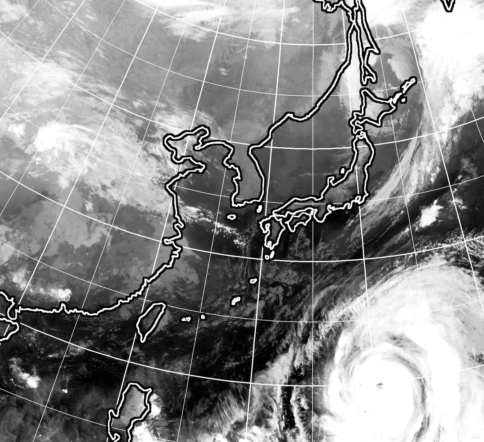
Typhoon Hagibis, which the U.S. military's forecasting agency has put on par with a Category 5 hurricane, is approaching Japan's main island of Honshu after a rapid intensification in the Pacific and could make a direct pass over the Kanto region this weekend.
The storm, which tracked near the Ogasawara islands through Wednesday, is forecast to continue moving toward Honshu, weakening only slightly before a possible landfall on Saturday night or early Sunday morning.
More precise forecasts for its path are still difficult, and a turn to the west toward central Japan or the east toward the sea remain among the possibilities.
However, its large size means that areas not facing a direct hit could still be significantly impacted. Speaking during a news conference Wednesday, a Meteorological Agency official urged caution against heavy rain, strong winds, high waves and storm surge.
East Japan Railway Co. President Yuji Fukasawa said Tuesday that the firm would consider suspending train operations in advance if the forecast path doesn't change.
Hagibis has drawn the attention of experts from around the world for its rapid intensification. According to the Meteorological Agency, air pressure at the center of the typhoon had fallen by 77 hectopascals to 915 over the 24-hour period to 6 p.m. Monday. A further dip, to 905 hectopascals, was forecast by Wednesday evening, according to the agency.
Meteorologist Robert Speta, an expert on typhoons who now works for the U.S. Navy in Florida, said the storm had gone through an "explosive intensification."
"The storm went from a tropical storm to a violent typhoon in the matter of hours. In fact it was an historic amount of intensification in such a short time," he said. "This only happens when all the right ingredients are in place. Like if you had a fire and instead of throwing gasoline on it to make it bigger you also grabbed some lighter fluid, a bit of oil and a couple of aerosol cans for good measure."
Kazuhisa Tsuboki, an expert on typhoons and a professor at the Institute for Space-Earth Environmental Research at Nagoya University, agreed that the storm's intensity — as well as its size — make it stand out.
Tsuboki said high sea-surface temperatures have contributed to the intensity of Hagibis, which formed in the warmest part of the Pacific Ocean with temperatures hovering around 30 degrees Celsius.
Speta, who spent five years based in Tokyo as a meteorologist for NHK World and had previously done related work for the U.S. Navy in Japan, said coastal areas of the Kanto region should be on particularly high alert.
"This storm should be a classic recurve type storm with the worst of it being on the easterly side as it moves north. The big difference here is that some coastal areas are still recovering from Typhoon Faxai last month," he said, referring to one of the strongest storms on record to hit the Kanto region.
Those in the storm's path should stay away from the coast and remain indoors, Speta said, adding that keeping up with the latest forecast information is key.
"Looking at old information could be dangerous," he said.
While exact figures about the storm's strength differ by agency, there is no doubt that it is a dangerous typhoon that could cause serious damage, impact public transportation networks and disrupt events — including the Rugby World Cup.
As of Wednesday afternoon, the Meteorological Agency described the storm as "violent" — its highest classification — adding that the storm had sustained winds of 198 kph. The U.S. military's Joint Typhoon Warning Center, observing higher sustained winds of 259 kph, classified Hagibis as a Category 5-equivalent super typhoon.
The agency's forecast shows the storm peaking in intensity on Wednesday before undergoing a slight weakening. Whether it makes landfall or curves out to sea, it could still be ranked by the agency as "very strong" — the second-highest rating — as it approaches Japan this weekend. That would put it on par in terms of landfall-intensity with last year's Typhoon Jebi, which hit the Kansai region, and Faxai, which caused widespread damage in the Kanto area in September.
If the storm makes landfall, it could have a central pressure of 950 hectopascals and sustained winds of 144 kph, forecasts show.
"Winds of such speed pose a danger to anyone who is outdoors, and it is possible that strong winds may knock down utility poles or street lamps ... or blow away trucks or cars that may struggle to maintain stability," an analyst from the Meteorological Agency warned. "Needless to say, (Hagibis) is likely to bring very dangerous winds."
The analyst added that many areas of Japan were likely to observe heavy rains and strong winds from Friday.
Tsuboki, of Nagoya University, believes that as global warming progresses, Japan is likely to see more typhoons on the same scale as Hagibis.
"Increased typhoon intensity is linked to the rise of sea-surface temperatures over the past 100 years," he said.
Tsuboki also believes the technology used by Japan to forecast typhoons and other tropical cyclones is not precise enough, which could impact disaster prevention.
The Meteorological Agency currently forecasts typhoons by analyzing satellite images.
The agency's data shows that the central pressure of Hagibis has remained at 915 hectopascals for about 24 hours, but Tsuboki argues that this figure could be inaccurate.
"It is unlikely that a typhoon would maintain the same pressure for so long, as typhoon intensity repeatedly rises and falls," he said.
He said the storm's actual pressure could be much lower — perhaps even around 900 hectopascals. "While the existing forecasting system used by the Meteorological Agency allows for quite accurate predictions of a typhoon's trajectory ... it can't predict wind speed and central pressure accurately," he said.
Among suggested measures to improve the accuracy of forecasts, Tsuboki suggested the agency "fly planes into typhoons to monitor the intensity closely," adding that data obtained using such methods, which have long been in use in the U.S. and Taiwan, have proven more valid. Japan is lagging behind other nations in this area, he said, despite it being a frequent target of typhoons.
"It's essential (for Japan) to acquire planes to monitor typhoons to better prepare for natural disasters," he said.


Reader Comments
to our Newsletter