Storms
S


Bulb

US: Early Snowstorm Leaves Millions Without Power

Image
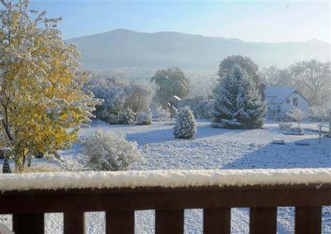
© Reuters/Adam HungerA view of a pumpkin patch covered in snow is seen in Portsmouth, New Hampshire October 30, 2011.
More than 3 million households in the Northeast lacked power Sunday as a rare October snowstorm bedeviled transportation and killed at least five people.

The record-breaking snow was heaviest in the western Massachusetts town of Plainfield, where 27.8 inches fell according to the National Weather Service. Northwest of New York City, in West Milford, New Jersey, 19 inches of snow fell.

"It's too scary -- the windows are rattling too loud," a terrified Sophia Band, 6, said, her father recalled, during the crushing storm in Conway, Massachusetts overnight.

The snowy, windy weather that began Saturday was expected to exit Maine later Sunday, but not before dumping up to a foot of snow on northern New England, particularly southern Vermont, the National Weather Service said.

Howling winds and heavy, wet snow snapped enormous trees like twigs, downing power lines from West Virginia to Massachusetts.

By midday Sunday, there were close to 3.2 million households without electricity across the Mid-Atlantic and New England, according to Weather.com.

Connecticut Governor Dannel Malloy said the state experienced the largest number of power outages in its history. Maine, Massachusetts and New Jersey all said they did not expect service to return to normal for several days, while in Connecticut it could be more than a week.
Cloud Lightning

Early snowfall, rain pounds Atlantic Canada as U.S. storm moves north

Image
© Environment CanadaEnvironment Canada has issued wind and rain warnings for the various parts of the Maritimes Saturday night and into Sunday.
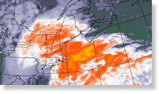
An unseasonably early snowstorm that has pounded the U.S northeast is making its way through parts of Atlantic Canada.

Heavy rainfall soaked much of the Maritimes while snow fell in parts of New Brunswick, as far south as Saint John.

Meteorologist Jeffrey Hilliard says the major concern is a mix of rain, snow and high winds that are causing hazardous driving conditions in some areas.

The City of Saint John sent out a notice urging drivers to use caution as crews were heading out to sand and salt the city's roads.

RCMP in eastern Prince Edward Island reported that a driver was killed near Pooles Corner on Route 3 early on Sunday.

Police say road conditions were a factor in the death, along with the lack of a seatbelt and the high speed of the car.

In addition, the Confederation Bridge sent out an advisory that due to strong winds the bridge was closed to cars towing trailers, motorcycles, recreational vehicles, trucks and buses.

Bizarro Earth

US: Snow Smacks Northeast; Power Could Be Out for Days

Millions of people from Maine to Maryland were without power as an unseasonably early storm dumped heavy, wet snow over the weekend on a region more used to gaping at leaves in October than shoveling snow.

Image
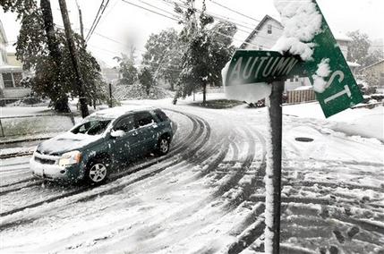
© AP Photo/Julio CortezA vehicle makes its way at the snow-covered intersection of Autumn and Grove Streets in Lodi, N.J., following a rare October snowstorm that hit the region, Saturday, Oct. 29, 2011.
The snow was due to stop falling in New England late Sunday, but it could be days before many of the more than 3 million without electricity see it restored, officials warned. The storm smashed record snowfall totals for October, and several officials called its ferocity historic.

At least three deaths were blamed on the weather, and states of emergency were declared in New Jersey, Connecticut, Massachusetts and parts of New York.

The storm worsened as it moved north, and communities in western Massachusetts were among the hardest hit. Snowfall totals topped 27 inches in Plainfield, and nearby Windsor had gotten 26 inches by early Sunday.

Snowman

US: Historic October Snowstorm Hammering Northeast

A significant, rare October snowstorm will plow through the Northeast Saturday through early Sunday morning. Scroll down or use the links below to view the forecast and current conditions to guide you through the storm.

Video: Why Such a Large Power Outage Threat?


Attention

Crushing, Cruising Snowstorm Unfolding in the Northeast

fall snow storm ne US
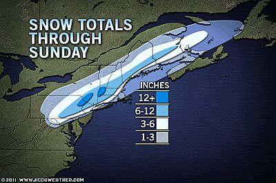
© www.accuweather.comThis map shows the expected storm total snowfall on non-paved surfaces through Saturday night. However, in the heaviest snowfall areas, a slippery, slushy accumulation is likely even on major highways. A few pockets within the heaviest snow band can receive from one to two feet of crushing snow with snowfall rates possibly reaching 2 to 4 inches per hour, complete with thunder and lightning.
A foot of heavy wet, back-breaking snow will plaster areas north and west of I-95 Saturday, causing massive power outages, downed trees and travel nightmares.

The storm will hit hard and fast, traveling from southwest to northeast over the mid-Atlantic and New England in less than 24 hours. In most of the mid-Atlantic the storm began as rain, but a change to snow will progress throughout the day.

The heaviest snow from the storm will stretch from along the Virginia/West Virginia border through a large swath of central and eastern Pennsylvania to southeastern New York state, northwestern New Jersey, northern Connecticut, central and western Massachusetts to southern New Hampshire and southwestern Maine.

Cities and towns that are likely to receive the heaviest snowfall include: Torrington, Conn., Hagerstown, Md., Springfield, Mass., Nashua, N.H., Netcong, N.J., Kingston, N.Y., Honesdale, Pa., Winchester, Va., Brattleboro, Vt. and Martinsburg, W.Va.

In these areas and others over the interior Northeast, the snow will come down hard enough to accumulate on the roads making for slippery driving. The worst conditions will be in the hilly areas and the mountains, where slightly lower temperatures are in store.

Thousands of trees could come down, and over a million people could be without power. Some rural roads could be blocked for days by fallen trees. Driving or walking through wooded areas during and immediately following the storm could be dangerous.

Igloo

US, Connecticut : Record-Breaking Freak October Snow

Historic storm could dump a foot of snow in parts of the state this weekend.


It took mere hours to break the record for snowfall in Connecticut in October and, by 4 p.m., Gov. Dannel Malloy had ordered all non-emergency vehicles off the roads.

Many Connecticut residents have no power and several cities and towns have activated emergency operations centers.

As of 4:30 p.m., more than 7 inches have fallen in New Fairfield and the snow just keeps coming down. By daybreak on Sunday, the northwestern part of the state could get up to 15 inches.

Heavy snow is expected statewide on Saturday night, along with strong, gusty winds and falling temperatures.

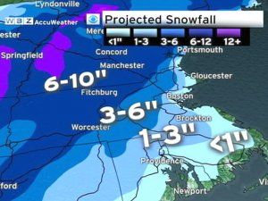
By the time all is said and done, 6-10 inches is expected through much of inland Connecticut though Litchfield County is expected to receive 10-15 inches. Along the shoreline the greater New Haven area can expect 3-6 inches while southeastern Connecticut gets 1-3 inches.

Snowman

US: Early Storm Pelts East Coast with Wet, Heavy Snow

Image
© The Associated Press / Julio CortezA jack-o-lantern is covered with snow during a rare October snowstorm that hit the Northern New Jersey region, Saturday, Oct. 29, 2011, in North Bergen, N.J. A classic nor'easter is moving along the East Coast and is expected to dump anywhere from a dusting of snow to about 10 inches throughout the region starting Saturday, a decidedly unseasonal date for a type of storm more associated with midwinter.
A classic nor'easter was chugging along up the East Coast and expected to dump anywhere from a dusting of snow to about 10 inches throughout the region starting Saturday, a decidedly unseasonal date for a type of storm more associated with midwinter.

Communities inland in mid-Atlantic states were getting hit hardest. Cherry Grove, W.Va., on the edge of the Monongahela National Forest, already got 4 inches of snow overnight, according to the National Weather Service. Heavy snow was falling in western Maryland, and the Frostburg area could receive 8 or 9 inches. Along the Blue Ridge Mountains between Hagerstown and Frederick, significant snowfall was also expected.

Tens of thousands lost power in Pennsylvania, and utilities were bringing in crews from Ohio and Kentucky to help. Officials warned that the heavy, wet snow combined with fully leafed trees could lead to downed tree branches and power lines, resulting in power outages and blocked roads.

A steady midday heavy snow pelted the field at Beaver Stadium in State College, where No. 21 Penn State was to host Illinois. Mother Nature cooperated with calls for a "whiteout," in which fans wear all white to the game in an occasional tradition for big games at the school. A few hours before the midafternoon kickoff, about 3 inches had already fallen.

The heaviest snow, though, was forecast for later in the day into Sunday in the Massachusetts Berkshires, the Litchfield Hills in northwestern Connecticut, southwestern New Hampshire and the southern Green Mountains.

"It's going to be wet, sticky and gloppy," said NWS spokesman Chris Vaccaro. "It's not going to be a dry, fluffy snow."

Cloud Lightning

Record-breaking rainfall brings sudden and severe flooding to Dublin, Ireland

Image
Water cascades down a staircase at Dundrum shopping centre in south-east Dublin. Image taken from a video posted on Youtube by Showars.
Dublin's officials began the onerous task of piecing the capital back together again on Tuesday after a torrential downpour the day before swelled the city's main waterways, causing them to burst their banks. Water spilled over into the streets, and the flooding quickly prompted Dublin's City Council to enact its "major emergency plan", which saw it send out Council staff and the Dublin Fire Brigade to help assist in the disaster.

According to Ireland's national meteorological service, Met Eireann, the Dublin region saw 82.2mm of rainfall Monday, the equivalent of one month's worth and by far the most since records first began there in 1954.

As rain continues to dump down on Dublin on Tuesday, the city has begun to take stock of the damage. Thus far, the flooding has wreaked havoc on transportation to and from the capital, with significant delays on several of Dublin's main routes and its DART commuter train service. Homes, main arteries and even one of the city's largest commercial complexes, Dundrum shopping centre, have been inundated with water.

Igloo

US: Major Nor'Easter To Dump More Snow On Southern New England

Boston - A major nor'easter is about to pound southern New England with heavy rain, snow and wind.
Image
© CBS BostonProjected Snowfall Map
In more than 100 years of record keeping in Boston the most snow the city has ever seen in the month of October is 1.1 inches, six years ago on October 29, 2005.

This storm is almost certain to be one for the record books in all of southern New England.

Timeline

The precipitation will begin Saturday afternoon between 3 and 5 p.m., as mainly rain for all of eastern Massachusetts, a mix in higher elevations to the west.

The intensity of the precipitation will increase rapidly over the next several hours and the rain-snow line will collapse to the south and east as colder air is drawn into the deepening storm on shifting winds to the north.

By midnight, it will be snowing just about everywhere with the exception of southeastern Mass. where it will continue to rain very heavily.

The rain-snow line will collapse further southeast to around the Cape Cod Canal in the pre-dawn hours of Sunday morning before the storm system pulls away and the precipitation shuts off just after dawn.

Igloo

US: Up to 6 inches forecast for East Coast

National Weather Service issues winter storm watch for Pa., Md., Va. and W. Va

It may still be October, with the World Series in full swing, but some parts of the East Coast could be in for an unexpected wintry blast of up to 6 inches of snow this weekend.


The National Weather Service issued a winter storm watch for Pennsylvania, Maryland, Virginia and West Virginia from Friday night through Saturday afternoon as a storm blows through the region. Even more snow was expected to fall in higher elevations, including the Laurel Highlands and the Pocono Mountains, forecasters said.
Image
© Vyto Starinskas/APRutland, Vt., residents woke up to this view to the east on Friday, as a storm left a cover of snow, in Killington, Vt. There were up to six inches of snow atop Killington.
Temperatures were expected to drop into the 30s across much of the Northeast by Friday morning. Boston got its first dusting late Thursday night.

Forecasters warned that the early snow could bring down tree limbs - something that Colorado got a dose of this week.

About 12,000 homes and businesses along Colorado's Front Range were still without power Friday morning following a fall snowstorm that downed trees and power lines. Outages were in metro Denver and Boulder and in Greeley, Fort Collins and Loveland to the north. The storm Tuesday and Wednesday brought about six inches of snow to Denver and about a foot to Greeley.