Storms
S


Cloud Precipitation

Tropical Storm Son-Tinh leaves 8 dead, nine missing in Philippines

Phillipines
© Google Maps
Tropical Storm 'Ofel' (international name: Son-Tinh) left at least eight people dead and nine missing on Friday before heading away from the country's area of responsibility toward Vietnam and southern China.

National Disaster Risk Reduction and Management Council (NDRRMC) Executive Director Benito Ramos said the fatalities included an 88-year-old woman who allegedly died of hypothermia and 77-year-old man hit by a falling tree, both in the central Philippines.

NDRRMC reported three persons drowned in separate incidents, two children killed by a falling tree and a girl buried in a landslide in separate incidents in the central and southern Philippines.

Cloud Lightning

Powerful typhoon set to strike central Vietnam

typhoon Son Tinh
© National Hydro-Meteorological Forecasting Center The expected path of the typhoon
Typhoon Son Tinh is moving fast in the East Sea towards central Vietnam and is forecast to hit the area tonight if its current route remains unchanged, said the National Hydro-Meteorological Forecasting Center.

With a speed ofn about 25 km, Son Tinh is the fastest storm that has affected Vietnam in the past 10 years, said agriculture minister Cao Duc Phat who is also head of the Central Steering Board for Flood and Storm Prevention and Control.

The storm is expected to be 160 km east of the coast of Nghe An and Thua Thien-Hue, with winds of 103-132 kph and gusts of over 132 kph this evening, the center reported.

Cloud Grey

'After 26 years in TV weather and two years with NOAA, Sandy may pose the greatest risk to human life that I have seen': Hurricane Sandy even looks scary from space

New York has just been declared a state of emergency in advance of Hurricane Sandy which is expected to hit the East Coast late on Sunday, with the possibility it will halt subways and ground planes. Governor Cuomo said the declaration allows the 62 counties to help localities better prepare for the storm with access to federal funding and the national guard.

Hurricane Sandy is looking more and more ominous as it makes its way towards the East Coast, and local authorities are preparing for the worst, predicting at least $1billion in damage and the possibility and up to 375,000 New Yorkers could be evacuated. Meteorologists expect a natural horror show of high wind, heavy rain, extreme tides and maybe even snow on higher ground beginning early on Sunday.

Image
© AFP/Getty ImagesThis NASA TV frame grab shows Hurricane Sandy from the International Space Station as it barrels up the Atlantic Coast of the United States

Cloud Lightning

Hurricane Sandy devastates the Bahamas leaving 22 dead

Image
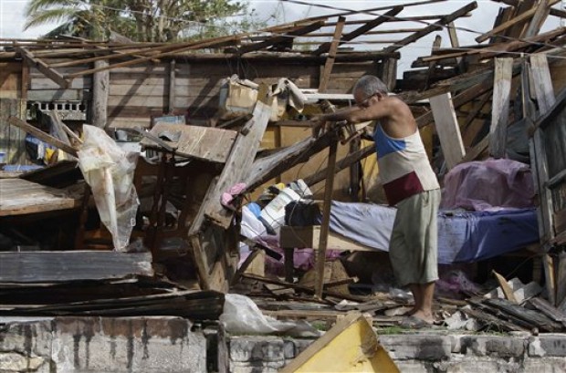
© AP Photo/Franklin ReyesResident Antonio Garces tries to recover his belongings from his house destroyed by Hurricane Sandy in Aguacate, Cuba, Thursday Oct. 25, 2012. Hurricane Sandy blasted across eastern Cuba on Thursday as a potent Category 2 storm and headed for the Bahamas after causing at least two deaths in the Caribbean.
Hurricane Sandy raged through the Bahamas early Friday after leaving 22 people dead across the Caribbean, following a path that could see it blend with a winter storm to hit the U.S. East Coast with a super-storm next week.

Sandy knocked out power, flooded roads and cut off islands in the storm-hardened Bahamas as it swirled past Cat Island and Eleuthera, but authorities reported no deaths in the scattered archipelago.

"Generally people are realizing it is serious," said Caroline Turnquest, head of the Red Cross in the Bahamas, who said 20 shelters were opened on the main island of New Providence.

Cloud Lightning

Hurricane Sandy hits Cuba hard; 11 deaths reported

Hurricane Sandy Cuba
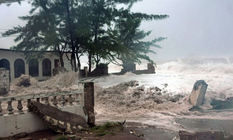
© Collin Reid/APWaves, brought on by Hurricane Sandy, crash on a house in the Caribbean Terrace neighbourhood in eastern Kingston, Jamaica
Cuban state media have announced 11 deaths from Hurricane Sandy, including a 4-month-old boy who was crushed when his home collapsed.

State TV's nightly newscast says nine of the deaths were in Santiago province in eastern Cuba, which is home to Cuba's second largest city. It is also known as Santiago.

The other two deaths were reported in Cuba's Guantanamo province, bordering the U.S. naval base at Guantanamo Bay.

The newscast says the oldest victim was an 84-year-old man in Santiago province.

The report of the deaths came at the end of the newscast.

Cuban authorities say most of the fatalities occurred when dwellings fell down, but the cause of others is still being investigated.

Comment: Eleven deaths is a significant death toll for Cuba considering they have one of the world's best hurricane preparedness programs. Not including Hurricane Sandy, they've lost 35 people in hurricanes since 2001 despite consistently being in the the center of these storms. Perhaps they got caught by surprise. Time will tell if this foreshadows how the storm is received by many in the east coast. The storm is set to collide with an early winter storm coming from the west and an arctic blast coming from the north. So, make sure you all are prepared!


Cloud Precipitation

Hurricane Sandy could outdo 'perfect storm'

Hurricane Sandy
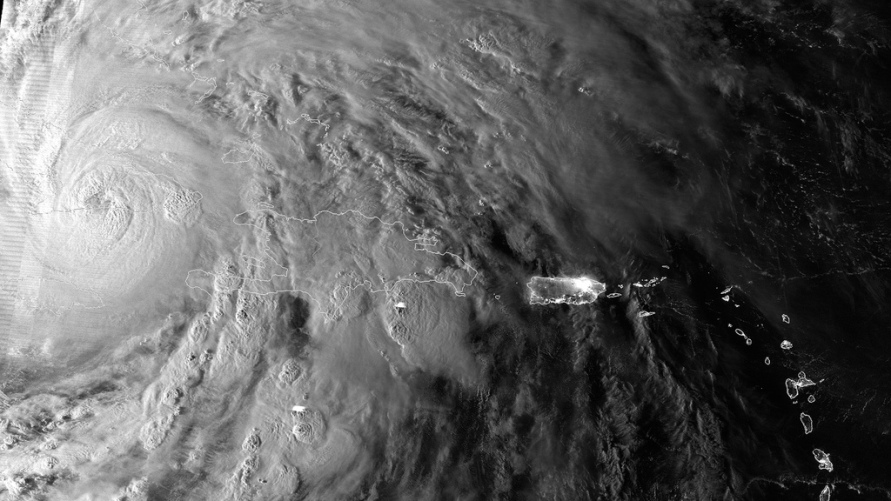
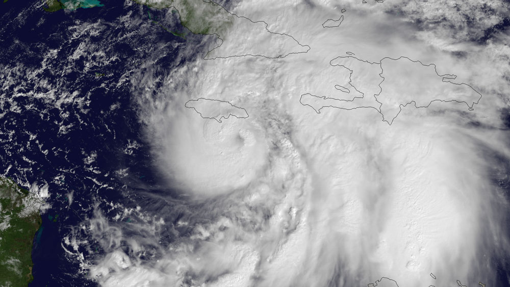
© NOAA/NASA/GSFC/SuomiNPPThe Suomi NPP satellite caught this image of Hurricane Sandy yesterday morning (Oct. 25), just as the cyclone passed over Cuba.
A frightening collision of weather systems is brewing and could create a tempest even worse than 1991's "Perfect Storm." This "Frankenstorm," as some are calling it, is set to strike the Northeast on or near the 21st anniversary of that historic squall.

On the one hand you have Hurricane Sandy barreling north, expected to hit somewhere on the U.S. East Coast in the middle of next week. At the same time, a cold front is moving across the middle of the country, bringing cold temperatures and snow.

The two will probably meet about the time the hurricane makes landfall and, together, could form an even bigger nor'easter (snor'eastercane, some have said). And that's bad news.

"In all likelihood, it will be worse than the Perfect Storm," said William Komaromi, a hurricane expert at the University of Miami.

Snowflake

Hurricane Sandy could bring snow to Eastern Canada next week

Image
Are we ready for winter? A number of converging factors could dump snow in Atlantic Canada early next week.
This morning, U.S. forecasters are predicting a convergence of Hurricane Sandy, an early winter storm in the west and cold arctic blast from north which would make for some very messy and expensive weather over the Northeast US and Atlantic provinces for the first half of next week.

"It'll be a rough couple days from Hatteras up to Cape Cod," said Jim Cisco, a forecaster with the National Oceanic and Atmospheric Administration (NOAA). "We don't have many modern precedents for what the models are suggesting."

Forecasting the weather 4 or 5 days before it happens is difficult because so much can change in that time. However, it's also difficult to dismiss the results when every piece of guidance you use starts pointing towards the same thing, with even greater certainty, each time you update your forecast.

That's what's happening right now.

The computer models forecasters use for guidance in making their forecasts showed the first indications of the merger of these weather systems, and the results of each subsequent model have made it more and more likely.

Cloud Precipitation

Early worries that hurricane Sandy could be a 'perfect storm'

Hurricane Sandy_1
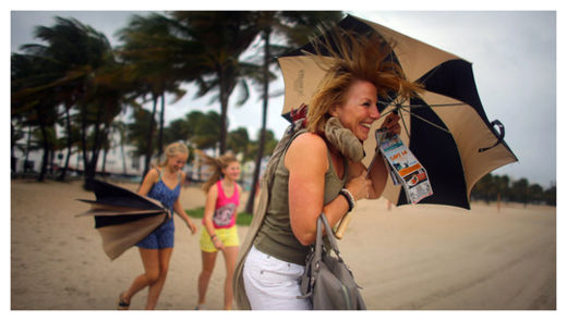
© Joe Raedle/Getty ImagesLaura Rath and her family in Miami Beach on Thursday. The hurricane could become “a giant storm complex with a lot of energy,” one expert said.
Hurricane Sandy, which on Thursday was barreling through the Bahamas as a Category 2 storm, may be taking aim at the northeastern United States and could make landfall along the Atlantic coast early next week. If so, forecasters say, the storm could become, to use a technical term from meteorology, a whopper.

"It really could be an extremely significant, historic storm," said Brian McNoldy, a senior research associate at the University of Miami, explaining that conditions are similar to those that created the famous "perfect storm" of 1991.

Hurricane prediction is, of course, an iffy business, said Dennis Feltgen, a meteorologist and spokesman for the National Hurricane Center, who noted that the storm was still days from the East Coast and could weaken drastically or even shift course and race off into the Atlantic.

The chain of events that would make Hurricane Sandy develop into a grave threat to the coast involves a storm system known as a midlatitude trough that is moving across the country from the west. If the systems meet up, as many computer models predict, the storm over land could draw the hurricane in.

"Now you've got this giant storm complex with a lot of energy," Mr. Feltgen said. The combined systems could produce high winds, heavy rains and storm surges that would cause extensive damage.

Cloud Precipitation

Blocking Jet Stream may force "Snor'eastercane Sandy" towards Northeastern US

Image
© KeystoneUSA-Zuma/Rex FeaturesThe Manhattan skyline as Hurricane Irene approached last year. Sandy could hit New York City next week... with snow!
2011 meteorological autumn was unusual in that both a hurricane and an October snowstorm hit the north-east. They occurred two months apart, and the idea that either one would happen again in the near-term was not something high up on the probability scale. But if there is one thing more unpredictable than politics, it's the weather.

Government forecasters are warning that the US east coast is likely to be battered next week, not by a winter storm or a hurricane, but by an unusual combination of steady gale-force winds, flooding, heavy rain and possibly snow. It has already been dubbed the "snor'eastercane".

Hurricane Sandy is currently approaching the Bahamas. With 105mph winds and a central low pressure of 964 millibars, Sandy seems likely at this point to hit the east coast of the United States. Where and how Sandy will make her mark is still very much up in the up air.

Here's what we know for sure: the National Hurricane Center's latest track has Sandy staying well off the coast for the next 72 hours. Pretty much all weather models agree on this track. Most often that a storm such as Sandy would go out to sea at this point - following the warm waters of the Gulf stream.
Image
© National Hurricane Center

Cloud Grey

Why so many hurricanes this year?

Hurricane Sandy
© NOAANOAA's GOES East satellite snapped this image of Hurricane Sandy at 10:45 a.m. EDT (1445 UTC) on Oct. 24, 2012, as it was headed for landfall on Jamaica.

Before the beginning of this hurricane season, back in May, forecasters thought this year would be an average one. Come August, when the season typically peaks, forecasters notched up their outlook, saying the season would in fact be busier than average.

Now it's October and it's been one of the busiest seasons on record, with 19 named storms so far this year, 10 of which became hurricanes, including Hurricane Sandy, which has the potential to strike the East Coast.

That puts the 2012 Atlantic hurricane season in rarified company. Only seven seasons since 1851 (as far back as hurricane records reach) have seen 19 or more named storms. Three of these have been within the last decade: the 2010 and 2011 seasons had 19 storms each and the 2005 season had a whopping 28 storms, the most on record, including Hurricane Katrina.

Originally the National Oceanic and Atmospheric Administration predicted there would be nine to 15 named storms this year. Then, in August, it upped its prediction to 12 to 17 named storms, with five to eight of those becoming hurricanes. (Storms are named once they attain tropical storm status - defined as a rotating, organized storm with maximum sustained winds of at least 39 mph (63 kph). A tropical storm becomes a hurricane once its top winds hit at least 74 mph (119 kph).

It's relatively unusual to have more storms than forecast, said Gerry Bell, the lead hurricane season forecaster at NOAA's Climate Prediction Center. So why has this hurricane season been busier than expected?

The underestimate can be blamed on El Niño, Bell told OurAmazingPlanet. Or rather, the lack of El Niño. Forecasters predicted that this climate pattern, characterized by warm surface temperatures in the Pacific Ocean, would have developed by now and stymied hurricane formation by its influence on the atmosphere. But it hasn't.