Government forecasters are warning that the US east coast is likely to be battered next week, not by a winter storm or a hurricane, but by an unusual combination of steady gale-force winds, flooding, heavy rain and possibly snow. It has already been dubbed the "snor'eastercane".
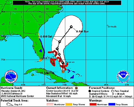
Hurricane Sandy is currently approaching the Bahamas. With 105mph winds and a central low pressure of 964 millibars, Sandy seems likely at this point to hit the east coast of the United States. Where and how Sandy will make her mark is still very much up in the up air.
Here's what we know for sure: the National Hurricane Center's latest track has Sandy staying well off the coast for the next 72 hours. Pretty much all weather models agree on this track. Most often that a storm such as Sandy would go out to sea at this point - following the warm waters of the Gulf stream.
The kicker here is that the jet stream, which carries weather systems across the country, is coming along at the perfect time and will block the eastward movement of Sandy.
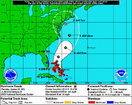
The jet will force the storm to head due north. The jet should then pick up the storm and bring it back towards to the coast. The result is a five day projection of Sandy as a tropical storm (ie winds of 39-74mph) into New York City by Tuesday midday.
Note how there is a wide range of uncertainty in Sandy's track. You should embrace that uncertainty because there is a large degree of unknown at this point. We don't know exactly how Sandy will interact with the jet.
The European model has a most forceful merging of the jet with Sandy and turns it into the coast somewhere around Virginia. That would lead to tremendous winds and coastal erosion to the north-east of there including New Jersey and up to New York City. This solution is mostly supported by the US navy model among others.
Earlier runs of the American GFS were on the opposite end of the spectrum, with less interaction with the jet stream causing the storm to make its way up to Maine before turning inward. That would lead to less impact further to the south as the strongest winds are on the north-eastern side of tropical storms. I must admit it I'm not really buying this solution as the latest run of the GFS is starting to look more like the middle ground spoken about below.
The middle ground track at this point seems to be the GFS ensembles and last night's run of the Canadian model. These models take Sandy parallel with the coast up to about the North Carolina/Virginia border before making a sharp left turn and into the New Jersey/New York City area. This solution would lead to heavy winds and rain on the order of perhaps a foot or more into the New York City metropolitan area. There would likely be coastal evacuations around New York City. Heavy rains could also extend back into areas away from the center such as Philadelphia.
Again though, this middle ground is merely one scenario, and we're many days away.
Within these different tracks, one thing is very clear: the storm is going to be very powerful. The models are printing out central low pressures of between 935 and 950 millibars. The lowest pressure on hurricane Isaac earliest this year was 968 millibars. What does that mean?
This low pressure indicates that even if you aren't in the center of the storm you're going to get hit pretty hard if you are anywhere near it. That's why the exact track of Sandy isn't as important as it might be otherwise. You'll see at least some rain from the Carolinas all the way up into New England. Combine this with a full moon, and there is going to be some major flooding along the coast for many miles.
The reason for this extremely low pressure is again due to the jet interaction. The air the jet stream is ushering in is rather cold. In fact, it's snowing right now in Minnesota. When you combine this cold air with the warm air of a cyclone of tropical origin, you're bound to get rapid intensification.
The rapid intensification will also help to drag down cold air that the jet is ushering in as atmospheric heights drop. Snow is unlikely in the big cities, but snow seems possible to the west-south-west of wherever the storm hits. It's this sector where we will have moisture as well as a cutting off of the warm air associated with the cyclone. You could get some good snow in the Northern Appalachian Mountains with perhaps minor accumulations from State College to Pittsburgh, Pennsylvania, and up to Buffalo, New York, if the middle ground track came to fruition.
Like the rest of the storm, we don't know where that snow line is going to be just yet and how much will fall where rain changes over to snow.
Overall, Sandy does not seem to be messing around. It's about as much the real deal as a storm can be at this point. We'll have to keep an eye out where the storm ultimately decides to go in the coming days.


Reader Comments
to our Newsletter