Storms
S

Road Cone

Frankenstorm Sandy: 16 dead and millions without power as Obama declares New York City major disaster area

Image
US President Barack Obama has declared a "major disaster" in New York state after storm Sandy smashed into the US East Coast causing flooding and cutting power to millions.

A record 4m (13ft) tidal surge sent seawater cascading into large parts of New York City's subway system.

Across the city, a power sub-station suffered an explosion, a hospital was evacuated and fire destroyed 50 homes.

At least 13 people are reported dead across several states.

An estimated 50 million people could be affected by the storm, with up to one million ordered to evacuate homes.

Sandy, now downgraded from a hurricane but described as a "super-storm", is churning north heading for Canada still packing torrential rain driven by gale-force winds.

Bulb

High winds leave tens of thousands without power across the Greater Toronto Area

Image
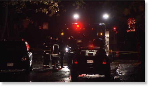
Firefighters attend to the scene on Lyall Road, a tree and hydro poll are down due to strong weather on Monday, Oct. 29, 2012.
Canada - Tens of thousands of residents across Ontario were without power early Tuesday morning as a powerful storm system worked its way through the province.

As post-tropical cyclone Sandy slammed into New Jersey's southern coast late Monday, its effects were immediately felt throughout the GTA, as high winds and heavy rain downed tree branches and power lines.

Early Tuesday, power outages affected:
  • More than 60,000 Hydro One customers
  • 26,000 Toronto Hydro customers
  • More than 15,000 Powersource customers
  • About 250 Enersource customers
In announcing widespread power outages late Monday night, Energy Minister Chris Bentley said that, "Trained crews of professionals are onsite across Ontario and working to restore power safely and as quickly as possible."

Toronto Hydro reassured residents earlier Monday they had 80 crews on standby to respond to calls as opposed to the usual 15 crews that they keep at the ready.

Apple Red

Storm damages crops in Haiti, fueling food price woes

  • Image
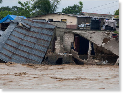
    © The Associated Press/Dieu Nalio CheryMany homes remain underwater in southern Haiti.
    Huge crop losses in southern Haiti raise famine worries
  • Flooding raises specter of cholera
  • Crop losses in Cuba, Jamaica as well
Port-au-Prince - As Hurricane Sandy barreled toward the U.S. East Coast on Monday, the full extent of the storm's havoc on Haiti was just beginning to emerge.

Extensive damage to crops throughout the southern third of the country, as well as the high potential for a spike in cases of cholera and other water-borne diseases, could mean Haiti will see the deadliest effects of Sandy in the coming days and weeks.

Haiti reported the highest death toll in the Caribbean, as swollen rivers and landslides claimed at least 52 lives, according to the country's Civil Protection office. More than three days of constant rain left roads and bridges heavily damaged, cutting off access to several towns and a key border crossing with the Dominican Republic.

"The economy took a huge hit," Prime Minister Laurent Lamothe told Reuters. He also said Sandy's impact was devastating, "even by international standards," adding that Haiti was planning an appeal for emergency aid.

"Most of the agricultural crops that were left from Hurricane Isaac were destroyed during Sandy," he said, "so food security will be an issue."

Sandy also destroyed banana crops in eastern Jamaica as well as decimating the coffee crop in eastern Cuba.

But the widespread loss of crops and supplies in the south, both for commercial growers and subsistence farmers, is what has Haitian authorities and aid organizations had worried about most.

The past several months have seen a series of nationwide protests and general strikes over the rising cost of living. Even before Hurricane Sandy hit, residents complained that food prices were too high.
Cloud Lightning

Hurricane Sandy barrels ashore, leaving path of destruction

Image
© The New York TimesA power failure affected most of Manhattan below Midtown.
Hurricane Sandy battered the mid-Atlantic region on Monday, its powerful gusts and storm surges causing once-in-a-generation flooding in coastal communities, knocking down trees and power lines and leaving more than five million people - including a large swath of Manhattan - in the rain-soaked dark. At least seven deaths in the New York region were tied to the storm.

The mammoth and merciless storm made landfall near Atlantic City around 8 p.m., with maximum sustained winds of about 80 miles per hour, the National Hurricane Center said. That was shortly after the center had reclassified the storm as a post-tropical cyclone, a scientific renaming that had no bearing on the powerful winds, driving rains and life-threatening storm surge expected to accompany its push onto land.
Image
© Ruth Fremson/The New York TimesWater rose from F.D.R. Drive on East 62nd Street in Manhattan.
The storm had unexpectedly picked up speed as it roared over the Atlantic Ocean on a slate-gray day and went on to paralyze life for millions of people in more than a half-dozen states, with extensive evacuations that turned shorefront neighborhoods into ghost towns. Even the superintendent of the Statue of Liberty left to ride out the storm at his mother's house in New Jersey; he said the statue itself was "high and dry," but his house in the shadow of the torch was not.

The wind-driven rain lashed sea walls and protective barriers in places like Atlantic City, where the Boardwalk was damaged as water forced its way inland. Foam was spitting, and the sand gave in to the waves along the beach at Sandy Hook, N.J., at the entrance to New York Harbor. Water was thigh-high on the streets in Sea Bright, N.J., a three-mile sand-sliver of a town where the ocean joined the Shrewsbury River.

Cloud Precipitation

Hurricane Sandy grows to a thousand miles wide as East Coast awaits arrival of 'storm of the century'

Hurricane Sandy has strengthened to nearly 1,000 miles wide with deadly winds in excess of 85 miles per hour - as hundreds of thousands of residents scrambled to higher ground, public transport systems shut down and thousands of flights across the country were cancelled.

The New Jersey shore is expected to take the brunt of the massive weather front - which forecasters said could be the largest in U.S. history - as Sandy hits near Atlantic City around 2am on Tuesday and churns north, with 50 million people in its path.

The worst of the Category 1 storm, which experts say is accelerating as it moves northwestward, is expected to bring a 'life-threatening' surge of seawater up to 11 feet high, coastal hurricane winds and a barrage of heavy snow in the Appalachian Mountains.

Nine U.S. states have declared states of emergency with the National Guard poised to swoop in, and President Obama has warned the nation to brace itself. 'This is a serious and big storm,' Mr Obama said after a briefing at the federal government's storm response center in Washington. 'We don't yet know where it's going to hit, where we're going to see the biggest impacts.'


Additional images

Cloud Precipitation

Superstorm: Part of famed Atlantic City boardwalk on verge of collapse

New Jersey - Hours before the worst of Sandy was supposed to come ashore, conditions in Atlantic City were already quickly deteriorating on Monday morning, with major street flooding and authorities reporting that the north end of the boardwalk is already on the verge of collapse.However, conditions were poor, making it difficult to travel to the area.

Massive waves pounded the beach and the entrances to the boardwalk were flooded and impassable. Three shelters are already reported full as Atlantic Avenue was already flooded with three feet of water at 7 a.m. and it was increasingly impossible to drive. Strong winds battered the boardwalk making it hard to stand. Emergency workers tried to get some of the homeless to leave but a few stubbornly stayed on their benches, at least until the worst of the storm arrives later today.


Cloud Precipitation

Eastern U.S. braces for dangerous superstorm

Image
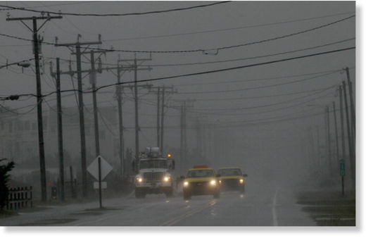
© The Associated Press/Gerry Broome Utilities and state road workers monitor the situation on Virginia Dare Trail as rain and wind from Hurricane Sandy engulf the beachfront road in Kill Devil Hills, N.C., Sunday, Oct. 28, 2012.
New York - From Washington to Boston, big cities and small towns were buttoned up Monday against the onslaught of a superstorm that threatened 50 million people in the most heavily populated corridor in the nation, with forecasters warning that the New York area could get the worst of it - an 11-foot wall of water.

"The time for preparing and talking is about over," Federal Emergency Management Administrator Craig Fugate said Sunday as Hurricane Sandy made its way up the Atlantic on a collision course with two other weather systems that could turn it into one of the most fearsome storms on record in the U.S. "People need to be acting now."

Forecasters said the hurricane could blow ashore Monday night or early Tuesday along the New Jersey coast, then cut across into Pennsylvania and travel up through New York State on Wednesday.

Airlines canceled more than 7,200 flights and Amtrak began suspending train service across the Northeast. New York, Philadelphia, Washington and Baltimore moved to shut down their subways, buses and trains and said schools would be closed on Monday. Boston also called off school. And all non-essential government offices closed in the nation's capital.

The New York Stock Exchange said it will be shut down Monday, including electronic trading. Nasdaq is shutting the Nasdaq Stock Market and other U.S. exchanges and markets it owns, although its exchanges outside the U.S. will operate as scheduled.

Windsock

Hurricane Sandy forces New York evacuations, mass transit closure

Transit officials in New York are preparing for a total shutdown of subway, bus and train service as Hurricane Sandy continues to bear down on the metropolitan region.


  • All service will be suspended at 7 p.m. on Sunday.

    New York Gov. Andrew Cuomo ordered the Metropolitan Transportation Authority to start planning for an orderly suspension of service.

    New York City subways and buses will start phasing out service at 7 p.m. Metro-North Railroad and the Long Island Rail Road will suspend service at 7 p.m. Sunday.

    The city's mass transit system is the nation's largest. The subway alone has a daily ridership of more than 5 million.

    Bizarro Earth

    A hurricane once more, Sandy defies the rules

    Sandy
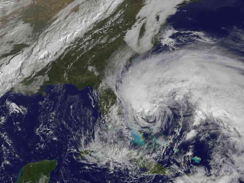
    © Handout/Getty ImagesIn this satellite image provided Friday by the National Oceanic and Atmospheric Administration, Hurricane Sandy's huge cloud extent of up to 2,000 miles churns over the Bahamas, as a line of clouds associated with a powerful cold front approaches the East Coast of the U.S.
    It's still unclear whether Sandy will be a devastating storm or just a bad one.

    It is clear, however, that Sandy will be remembered as the storm that broke all the rules and baffled the nation's top weather forecasters.

    Early Saturday morning, the National Weather Service downgraded the storm from a hurricane to a tropical storm - only to return it to hurricane status a few hours later. Either way, forecasters warn, "widespread impacts" are expected along the coast.

    Three days before reaching land - a time when the National Hurricane Center usually puts a bull's-eye on a small stretch of coast - government forecasters were still talking about the possibility of the storm striking anywhere from Maryland to New York.

    Their uncertainty was especially surprising because hurricane track forecasts have become so good in the past couple of decades. They are usually accurate five or more days out.

    Yet during a press conference on Friday, James Franklin of the NHC was still deflecting reporters' questions about Sandy's track. "We cannot be precise at this stage about exactly where it will come in," he said.

    Forecasters say Sandy just isn't like other hurricanes.

    "The whole thing is unprecedented," Henry Margusity of AccuWeather told NPR's Melissa Block. "We've never seen anything like this."

    Cloud Precipitation

    The true threat of hurricane 'Sandy'

    Mitt Romney cancelled one of three campaign stops this Sunday in reaction to the recent weather threat presented by hurricane "Sandy" which is predicted to affect parts of the eastern seaboard, thus stopping Romney from appearing at the Virginia Beach rally he had previously scheduled.

    Hurricane Politics
    © Official White House Photo/Pete SouzaPresident Barack Obama receives an update on the ongoing response to Hurricane Sandy
    Meanwhile, President Obama has already been briefed on the storm as of late Wednesday and east coast residents are urged to monitor local weather reports for what is being called a "super storm".

    With Sandy's wide wind field of 550 plus miles merging with a polar air mass over the eastern US, things could get pretty rough.

    The storm also has the potential to bring massive amounts of rain and snow.

    An excerpt from the New York Times reads, "The storm is also expected to dump as much as 10 inches of rain in the area where it makes landfall and to create a significant storm surge that will lead to flooding throughout a large coastal area, perhaps most seriously in Delaware, forecasters said.