Volcanoes
S


Info

Supervolcanoes Won't Destroy Earth in 2012

Yellowstone Volcano
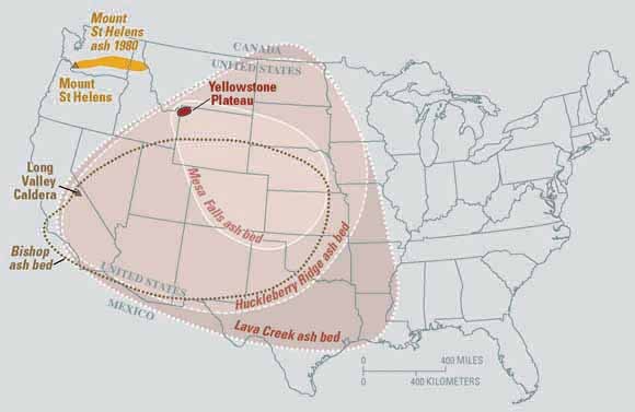
© USGSEruptions of the Yellowstone volcanic system have included the two largest volcanic eruptions in North America in the past few million years; the third largest was at Long Valley in California and produced the Bishop ash bed. The biggest of the Yellowstone eruptions occurred 2.1 million years ago, depositing the Huckleberry Ridge ash bed.
The notion that the world will end with the coming of the new year, as some claim the ancient Maya predicted, has spawned a series of proposed methods for this planetary disaster: galactic forces, Earth's magnetic poles flipping, the eruption of a supervolcano.

Though it has been shown that the Mayans did not in fact predict 2012 would bring the end of the world, there have been supervolcano eruptions in Earth's past that have wrought significant destruction. One such eruption may have been the cause of a major ancient mass extinction event.

But is another supervolcano eruption on the way? At the dawn of the new year, researchers say: Don't hold your breath.

Radar

Red Sea Volcano: New Island Forms Off Yemen Coast After Underwater Eruption

Image
© Getty Images
A new island has emerged in the Red Sea following an underwater volcanic eruption.

Fishermen first spotted the phenomenon, which is caused by lava fountains, earlier in December in a remote part of the sea close to the Yemen coast.

The fountains are reported to have reached more than 30 metres (90 feet) in height.

Nasa repositioned their satellite cameras to capture the event, resulting in some amazing shots of the volcanic explosion breaking the water.

Scientists are unsure whether the island will be permanent.

According to a Nasa spokesman the Advanced Land Imager on Nasa's Earth Observing-1 satellite captured the explosion.

"The image from December 2011 shows an apparent island where there had previously been an unbroken water surface," he said.

"A thick plume rises from the island, dark near the bottom and light near the top, perhaps a mixture of volcanic ash and water vapour."

The eruption occurred in a region of the Red Sea where the tectonic plates of Africa and Arabia meet, close to the Zubair Group of islands. Due to constant tectonic shifts, new ocean crust regularly forms along the rift.

Bizarro Earth

Indonesia: Lava Flood Kills 4 Near Mount Gamalama Volcano

Officials say fast-moving mudflows streaming from the mouth of a volcano in eastern Indonesia have killed four villagers. About 1,000 others have fled their homes. Mount Gamalama, located in the Molucca Islands, sprang back to life this month with a powerful, non-fatal eruption.


Government spokesman Yusuf Sunnya said Wednesday that days of heavy rains triggered flows of cold lava, rocks and other debris that slammed into villages near the base Tuesday night. He said four people were killed and more than a dozen others were hospitalized with injuries ranging from broken bones to head wounds.

Bizarro Earth

Volcanic Activity in the Red Sea

New Island in Red Sea
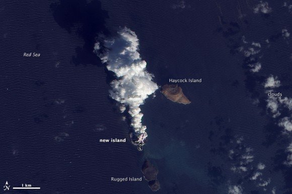
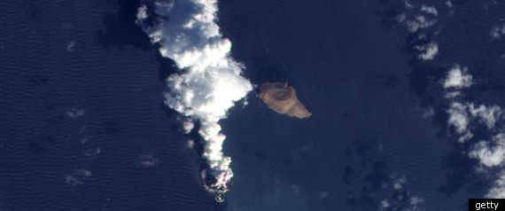
© NASAThe Advanced Land Imager (ALI) on NASA’s Earth Observing-1 (EO-1) satellite captured this high-resolution, natural-color images on December 23, 2011 showing an island being formed in the Red Sea.
New Island in Red Sea_1
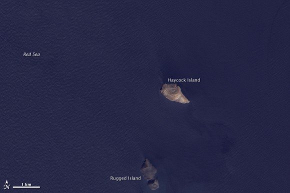
© NASASatellite image of the same region from October 24, 2007.
An eruption occurred in the Red Sea in December 2011. According to news reports, fishermen witnessed lava fountains reaching up to 30 meters (90 feet) tall on December 19. The Moderate Resolution Imaging Spectroradiometer (MODIS) on NASA's Terra and Aqua satellites observed plumes on December 20 and December 22. Meanwhile, the Ozone Monitoring Instrument (OMI) on NASA's Aura satellite detected elevated levels of sulfur dioxide, further indicating an eruption.

The activity in the Red Sea included more than an eruption. By December 23, 2011, what looked like a new island appeared in the region. The Advanced Land Imager (ALI) on NASA's Earth Observing-1 (EO-1) satellite captured these high-resolution, natural-color images on December 23, 2011 (top), and October 24, 2007 (bottom). The image from December 2011 shows an apparent island where there had previously been an unbroken water surface. A thick plume rises from the island, dark near the bottom and light near the top, perhaps a mixture of volcanic ash and water vapor.

The volcanic activity occurred along the Zubair Group, a collection of small islands off the west coast of Yemen. Running in a roughly northwest-southeast line, the islands poke above the sea surface, rising from a shield volcano. This region is part of the Red Sea Rift where the African and Arabian tectonic plates pull apart and new ocean crust regularly forms.
Bizarro Earth

Indonesia: Mount Lokon volcano eruption panics villagers

Image
© AFP/File, Glen RarungMount Lokon is one of Indonesia's most active volcanoes
One of Indonesia's most active volcanoes erupted Tuesday, spewing clouds of ash and panicking villagers but no evacuation has been ordered so far, a government vulcanologist said.

The first eruption at Mount Lokon was at 3:07 am (1907 GMT Monday), followed by two more bursts within minutes, Farid Bina told AFP from a monitoring post near the volcano on Sulawesi island.

"The eruption was heard as far as five kilometres (three miles) away, causing panic among villagers living close to the volcano," he said, adding that winds blew volcanic ash to villages up to five kilometres to the east and northeast.

"Two villages with about 10,000 people each have been affected by the ash, which stopped later in the morning," he added.

More than 5,200 people were evacuated to temporary shelters when the 1,580-metre volcano erupted in July, sending huge clouds of ash as high as 3,500 metres (11,500 feet) into the sky.

Lokon's last deadly eruption was in 1991, killing a Swiss tourist.

Cloud Lightning

Sakurajima back online -- several impressive eruptions

You will see 5 of the 10 eruptions which occurred today at Sakurajima. If you were to watch the videos in extreme fast forward, the volcano would appear like a steam engine -- literally giving off eruptions all day long at regular intervals.

In this video, you will see static discharge lightning, lava bomb/missiles/projectiles, and the entire mountainside covered in lava.

The volcano webcams were not uploading for at least a week, it is good to see the site back up and running !


Better Earth

Into the blue: Stunning images from within Iceland's tallest volcano

Glistening in the setting afternoon sun of an Icelandic winter, the Crystal Cave of Svmnafellsjvkull (CORR) in Skaftafell national park, highlights nature's beauty.

Created by the awesome forces of the Vatnajvkull ice cap in the south of the volcanic island, the deep blue cave was formed by the glacier meeting the coastline.

The centuries old ice that has come from the slopes of 6,921 feet tall Vrffajvkull, Iceland's tallest active volcano, has compressed all air out of the ice adding to the texture and colour of the cave.
Image
© Orvar ThorgeirssonNature at its best: Created by the awesome forces of the Vatnajvkull ice cap in the south of the volcanic island, the deep blue cave was formed by the glacier meeting the coastline
Accessible through a 22-foot entrance on the shoreline, the cave tapers to a tight squeeze at the end no more than four feet high.

'Blue ice like this deep blue occurs over hundreds of years and begins when simple snow falls onto ice or in this case a glacier,' said 35-year old photographer Orvar Thorgeirsson.

Bizarro Earth

Yemen Volcano Erupts in Red Sea

A fresh eruption at one of the volcanic islands off Yemen's Red Sea coast began on Dec. 19.

Fishermen report the eruption occurred near Saba, one of the Al-Zubair archipelago's small islands, located about 35 miles west of Yemen's port of As-Salif.

Image
© NASA - MODIS Rapid Response System
Lava was said to be spewing 65 to 100 feet into the air. The fishermen said they had never seen an eruption in that area before.

Bizarro Earth

US: Magma plume - profuse lava flow from Kīlauea breaches West Ka'ili'ili ocean entry for the first time in 4 years

Image
© Hawai‘i Volcanoes National Park
This media release is from the Hawaii Volcanoes National Park

Lava from Kīlauea's remote Pu'u 'Ō'ō vent has again reached the ocean within Hawai'i Volcanoes National Park boundaries, at a spot scientists have named the West Ka'ili'ili ocean entry.

The arduous hike to West Ka'ili'ili from the bottom of Chain of Craters Road is approximately four miles one-way across an uneven flow field. Currently, several streams of lava are pouring into the ocean, providing dramatic views. Visitors who stay after dark can also see channels of lava flowing down the pali and across the flow field, but conditions can change at any time.

Hikers need to heed all warning signs and ranger advisories, and be aware of earth cracks and crevices, sharp terrain and rain-slick pāhoehoe lava and other hazards. Steam plumes produced by lava entering the sea contain fine lava fragments and acid droplets that can be harmful. Scientists also confirmed that a lava delta is being formed at the base of a sea cliff at West Ka'ili'ili, and are monitoring the area closely. Lava deltas can collapse with little warning, produce hot rock falls inland, and generate large local waves.

Bizarro Earth

Myanmar - Rise of Underground Water Temperature Causes Volcano Mud Eruptions

Chiang Mai - An earthquake in Rakhine State has caused underground water temperatures to rise, setting off volcano eruptions of mud and small amounts of lava.

Erupting Volcano
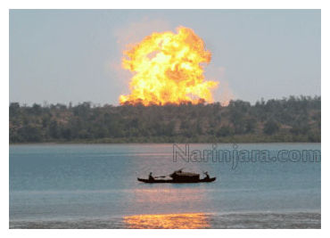
© NarinjaraA volcano erupting in the Kyaukphyu area in 2008.
Retired geologist Soe Thein said volcanos in the Kyaukphyu Township area on Ramree Island were set off along a fault line. More volcano mud eruptions might occur, he said, but there is no danger or need for mass evacuations.

"When there is earth crust movement in these fault lines, there will be underground water circulation and more water will move up to the surface as hot springs, but they are not like real volcanoes. They do not pose a danger to people," Soe Thein said.

The highest number of underground hot spring fault lines is in Kyaukphyu Township. The hot spring fault line runs through Magwe Region.

A mud volcano erupted on November 26 on a small hill one mile west of Bawyabaya village, about 32 miles from Kyaukphyu. The eruption sent magma and lava 15-feet into the air, and about 5 acres of nearby land was covered by magma.