Volcanoes
S


Bizarro Earth

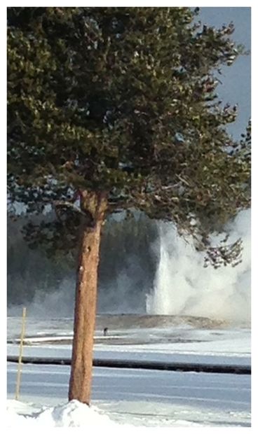
Yellowstone geyser erupts for first time in years

Giantess Geyser
© Bill WhetstoneGiantess Geyser erupts on the morning of Jan. 30, 2014, after starting the day before. The photographer was about 600 yards away from the geyser.
Yellowstone National Park's Giantess Geyser is erupting for the first time in two-and-a-half years, park rangers said today.

The usually quiet geyser is shooting off bursts of water that reach 50 feet (15 meters) into the air, said Annie Carlson, the supervisory park ranger at the Old Faithful Visitor Education Center. Giantess Geyser is nearby the more famous Old Faithful, but it is far less regular.

"We don't know when it will stop, and we don't know when it will go again in the future," Carlson told Live Science's Our Amazing Planet.

Sleeping giantess


There are more than 500 geysers in Yellowstone. Geysers occur when geothermally heated water gets trapped and pressurized in underground hot springs. The recurrence rate of geyser eruptions varies wildly.

Old Faithful erupts, on average, every 92 minutes, according to the National Park Service, though the exact timing varies between every 35 minutes and every 120 minutes. It shoots water 90 to 184 feet (27-55 m) into the air.

Yellowstone also boasts the world's tallest active geyser, the Steamboat Geyser. It has a major eruption only rarely, but when it does, the water rises as high as 300 feet (90 m).

Giantess is another infrequent erupter. It averages two to three episodes per year, with as many as 41 per year in the 1980s, Carlson said, but in recent years has slowed down, perhaps as a result of small earthquakes that continuously rearrange the underground plumbing of the park's geysers. The last time Giantess erupted was Sept. 13, 2011.
Blue Planet

Disassembling Hawaiian volcanoes - landslides part of the process

hawaiian volcano formation
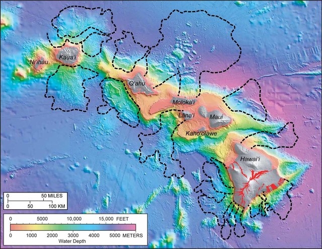
© West Hawaii TodayBlack dashed lines delineate 17 distinct landslides that have occurred around the Hawaiian Islands over the last several million years. The largest slides originated from the north sides of Oahu and Molokai. Colors ranging from pink to purple indicate the water depth around the islands, while shades of gray show land topography above sea level. Red areas on the Island of Hawaii indicate lava flows erupted within the past 200 years.
In our January Volcano Watch articles - Hawaii Island's fifth annual Volcano Awareness Month - we are exploring important questions about how Hawaiian volcanoes work. Last week, we discussed how Hawaiian islands grow; this week, we talk about how they fall apart.

In 1964, irregular submarine topography north of Oahu and Molokai was identified in newly available maps of the sea floor made by the U.S. Navy. James Moore, then Scientist-in-Charge at the USGS Hawaiian Volcano Observatory, suggested that this odd bathymetry might reflect massive landslides originating from those islands.

Moore's interpretation was disputed for more than 20 years until comprehensive mapping of the sea floor around the entire state of Hawaii was completed in the late 1980s. It turned out that Moore was right. Large - even catastrophic - submarine landslide structures litter the sea floor around the Hawaiian Islands. In fact, 17 major landslides have been identified off the shores of the main Hawaiian Islands. Fortunately, these slides are exceedingly rare - occurring, on average, only once every 350,000 years.

The largest landslides constitute significant portions of the islands from which they originated. Imagine if 10 percent of one of the islands suddenly collapsed into the ocean. Such an event would displace a huge amount of water and cause a large tsunami. Deposits of coral and sand have been found approximately 1,000 feet above sea level on several of the Hawaiian Islands. Catastrophic landslides are believed to have generated gigantic tsunami waves that washed ashore and left these deposits behind.

Camcorder

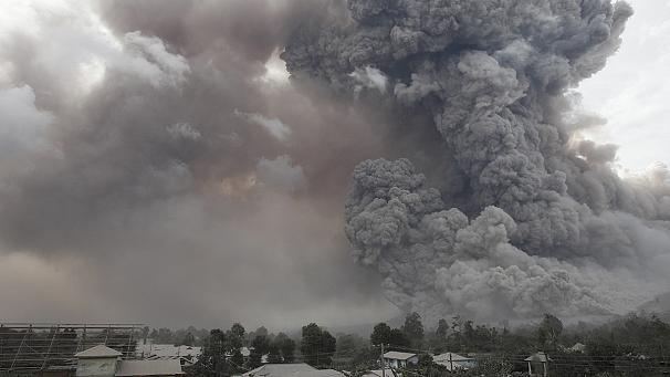
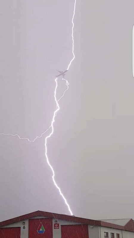
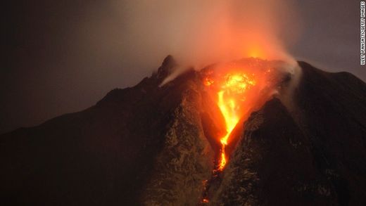
Electric universe: Previously dormant Mt Sinabung volcano in Indonesia spews river of fire, pyroclastic cloud and lightning (VIDEO)

Image
© CNN
Multiple eruptions send lava and searing gas tumbling out of the volcano in North Sumatra, Indonesia

Dramatic footage captured pyroclastic flow, a fast-moving current of hot gas and rock, glowing red and rare phenomenon like volcanic lighting as Mount Sinabung inIndonesia's North Sumatra province erupted again on Sunday.

The volcano was seen spitting clouds of gas and lava as high as 13,000 feet in several eruptions.

The 8,530-foot Mount Sinabung has sporadically erupted since September. More than 26,000 villagers have been evacuated since authorities raised the alert status for the volcano to the highest level in November 2013.


Bizarro Earth

Peru's El Misti volcano - signs of volcanic unrest, earthquake swarm during 14-15 January

The volcano experienced an earthquake swarm during 14-15 January, IGP reported in its latest bulletin. An increase of approx. 25% in seismic activity overall with respect to last year's average was calculated, but IGP stresses that this activity is still low and does not suggest new activity in a near future.

According to the report, a total of 418 seismic events were recorded during the first half of January, most of them during the swarm that occurred on 14-15 Jan when almost 120 quakes were registered within 17 hours. From these events, 144 were so called long-period quakes (internal fluid movements), 269 volcano-tectonic earthquakes (internal rock fracturing) and 5 short pulses of tremor (internal vibration).
Image
The report of IGP showing the signals of the seismic swarm at EL Misti volcano in Peru
El Misti, which is only 17 km from the center of Arequipa city, is one of the countries major and most active volcanoes. Due to its closeness to a large city and its history of explosive eruptions, it is also one of the most dangerous volcanoes in South America, and clearly one that deserves being closely monitored.

Bizarro Earth

Eruption of Shyhzerli volcano causes earthquake in Azerbaijan

Image
Eruption of the Shyhzerli volcano - one of the most active and largest mud volcanoes in Azerbaijan, occurred due to an earthquake, head of the Mud Volcanoes Department of Geology Institute of Azerbaijani National Academy of Sciences (ANAS), Professor Adil Aliyev told Trend on Jan. 17.

"The earthquake, which occurred at about 18 kilometres away from the volcano towards Shamakhi caused eruption of the Shyhzerli volcano. An earthquake occurred two or three days before the eruption," the scientist said.

The earthquake and the eruption did not occur on the same day, but sometimes such cases happen, Aliyev said.

"For example, 15 minutes after the Shamakhi earthquake that destroyed the city in 1902, there was a strong eruption of the Shyhzerli volcano. Such strong earthquakes result in the volcano erupting the same day. Volcanos may also erupt a day or two days after, when the seismic wave reaches it. We have found out that the volcano itself should be ready to erupt, there should be enough energy. The earthquake simply contributes to its eruption," the scientist said.

Info

Indonesia: Sinabung volcano erupts more than 30 times spewing ash and lava

Mt Sinabung
© Unknown
Indonesia's Mount Sinabung has erupted more than 30 times, spewing lava and ash clouds over a wide area, officials said, with more than 26,000 people now forced to flee their homes.

Mt Sinabung, which lies in the northwest of Indonesia's Sumatra island, sent hot rocks and ash 5 kilometres into in the air, spreading hot clouds over a 4.5-kilometre radius, said the Centre for Volcanology and Geological Hazard Mitigation.

Enormous clouds rose from the mountain, as thick layers of grey ash blanketed plantations and nearby houses.

With the volcano erupting regularly, many of those who have left their homes since Mt Sinabung started erupting in September have fallen ill, a local government official said.

"Some refugees are sick, coughing mainly, and they are also in need of clean water," said Robert Peranginangin, a spokesman for Karo district.


Bizarro Earth

El Salvadoran officials on alert for Chaparrastique Volcano activity

Image
The alert status remains today in El Salvador by seismic activity of the Chaparrastique volcano, except in the eastern department of San Miguel, where the volcano of 2130 meters above sea level is located. According to the latest special report from Ministry of Environment and Natural Resources (MARN), as vibrations persist and gases column is visible, the possibility of another eruption is not ruled out in the coming days or weeks through the central crater or their flanks.

Environment officials are urging people not to approach the volcano crater and abide by the instructions issued by the General Department of Civil Protection.

MARN explained that the vibration levels and emission have shown changes but remain.

Magnify

Catalhoyuk mural may depict ancient volcanic eruption

Image
© John Swogger Rendering of a wall painting discovered at Shrine 14 during the original excavations of Çatalhöyük by British archaeologist James Mellaart in the 1960s and said to depict Hasan Dagi erupting
A mural excavated at the Neolithic Çatalhöyük site (Central Anatolia, Turkey) has been interpreted as the oldest known map. Dating to 6600 BCE, it putatively depicts an explosive summit eruption of the Hasan Dağı twin-peaks volcano located 130 km northeast of Çatalhöyük, with a birds-eye view of a town plan in the foreground.

This interpretation has always been controversial, not least because independent evidence for a contemporaneous explosive volcanic eruption of Hasan Dağı has been lacking. However, recent volcanic rock dating suggests the painting of the Çatalhöyük mural may have overlapped with an eruption, according to results published in the open access journal PLOS ONE by Axel Schmitt from the University of California Los Angeles and colleagues from other institutions.

Analysed volcanic rock samples

Scientists analysed rocks from the nearby Hasan Dağı volcano in order to determine whether it was the volcano depicted in the mural. To determine if Hasan Dağı was active during that time, scientists collected and analysed volcanic rock samples from the summit and flanks of the Hasan Dağı volcano using (U-Th)/He zircon geochronology. These ages were then compared to the archaeological date of the mural.

Bizarro Earth

Geologists say North Sumatra's Mount Toba may erupt again, at any time

Image
Geologists and geophysicists say that Mount Toba, which erupted thousands of years ago, turning into Lake Toba, still contains a dangerous magma chamber and its activity needs further study. Indonesia Geological Experts Association president Rovicky Dwi Putrohari said the magma chamber could be observed in a study conducted by researchers recently. Rovicky added that researchers used the tomography method to detect the magma chamber.

Researchers said the Mount Toba magma chamber was located at a depth of between 20 kilometers and 100 kilometers.

"The method was used in the early stage of the study. Our researchers were able to find the location and dimensions of the magma chamber of Mount Toba. Later research will find out the potential volume of magma in the volcano for triggering an eruption," Rovicky told The Jakarta Post on the sidelines of a joint conference between the Indonesian Geological Experts Association and Indonesian Geophysics Experts Association in Medan, North Sumatra, recently.

Around 800 geologists and geophysicists took part in the conference, including scientists from Australia, France, Malaysia, Singapore and the United States. Rovicky said that during the three-day conference several studies related to the Mount Toba eruption were presented by experts, including Craig A. Chesner, from the Eastern Illinois University in the US.

Rovicky explained that based on Chesner's study in 2011, it was concluded that the current Lake Toba was the result of four previous eruptions.

Bizarro Earth

Mount Marapi spews thin grey smoke as second volcano in Sumatra erupts

Image
© ANTARA/Arif PribadiMt. Marapi view from Tanah Datar district, West Sumatra.
Mount Marapi in West Sumatra expelled thin grey smoke up to 200 meters from the crater into the sky, on Wednesday morning, stated spokesman of the Bukittinggi Volcanology and Geological Disaster Mitigation Agency (PVBMG) Warseno.

"The volcano spewed smoke after it showed signs of increased activity at 7.28 a.m. local time on Wednesday. Local residents should therefore, continue to stay alert," he warned.

The volcano, located in the Tanahdatar and Agam districts, West Sumatra, remains on the second highest alert level.