Extreme Temperatures
S


Snowflake

Record snowfall blankets Havre, Montana

What the winter will bring is still unclear

A second snowstorm hit north-central Montana over the weekend, bringing enough white stuff to tie a National Weather Service record for Havre on Nov. 10 set at 4 inches in 1916 and bringing some slippery driving conditions to the area.

Once again, the winter conditions are not expected to last, with temperatures expected to be in the 20s to 30s, depending on the forecaster, today and back into the 40s or even 50s later in the week.

The forecast calls for mostly sunny skies through the weekends with temperatures expected to drop some by Saturday or Sunday.

The long-range forecast still is up in the air, with The Farmers' Almanac predicting the region including Montana will be piercingly cold with about-normal snowfall, while the Old Farmers' Almanac predicts colder-than-normal winter temperatures here, with lower-than-normal precipitation and snowfall.

Blue Planet

SOTT Focus: Preparation for the coming storm

Our current collective condition has never been more precarious - at least not in our lifetime. Worldwide economic collapse seems certain, only the timing and severity can be debated. The planet seems to be convulsing through all kinds of changes, from weather extremes to increased earthquake/volcanic activity, to mass animal die-offs, to greatly increased bolide/fireball events.
Image
© sott.netRecent US fireball reports (including sound and fragmentation)
Some of these changes are reflected in changes we can see occurring on other planets in our solar system, and may be related to the bizarre behavior of our sun and/or the nature of space around our solar system. Respected meteorologists and atmospheric scientists are warning of an impending ice age - the beginning of which could occur rapidly and with little warning. Secondary concerns have been widely expressed regarding worldwide food supply, not to mention rising prices and environmental instability.

The point here is not to stimulate panic. The point is to focus on what we can do as individuals and groups to prepare a living environment that is mindful of potential threats - an environment we can create with the means at our disposal. Just thinking and planning around this is preparation itself.

Igloo

Best of the Web: German scientists: Solar cycle 24 points to Dalton or Maunder-like minimum, boding ill for a climate cooling

In October 2013 there was a considerable rise in solar activity as the sunspot number (SSN) climbed to 85.6. That's 77% of the mean value reached at this time into a solar cycle since 1750. The following diagram shows the current situation:

IceAge_1
© NoTricksZoneSSN versus months since the start of the cycle.
October 2013 deviates significantly from solar cycle number 5.

However we continue to believe that SC 24 will be similar to SC 5. Just how large the uncertainties of the correct description of the 5th cycle is shown by a recently published paper by Rainer Arlt of the Leibniz Institute Potsdam and Ilya Usoskin of the Finnish University of Oulo, who after examining the solar cycles between 1750 und 1850 reached the conclusion that the sunspot count should be lowered by 20%. SC 24 shown by the blue curve is, however, still very much below average, let alone well below the large cycles of the solar maximums from 1940 - 1990.

Snowflake

Record snowfall recorded in Spokane, Washington

man shoveling car
© Colin Mulvany
Spokane International Airport received 1.9 inches of snow Tuesday, according to the National Weather Service. The total was enough to snap a 66-year-old daily record by the slimmest of margins.

Before Tuesday, the most snow Spokane had officially received on Nov. 5 was 1.8 inches in 1947, according to National Weather Service records. The snowfall, which was timed perfectly to make the morning commute miserable for many motorists, tapered off around 2 p.m.

Forecasters expect temperatures to remain high enough to keep flakes away for the rest of the week, though chances for rain remain through Sunday. Showers on Thursday could grow heavy at times, with between a quarter- to half-inch of rain expected throughout the day.

Temperatures through Sunday should be in the mid- to upper-40s for highs and near freezing at night, forecasters say.

Snowflake

Record breaking snowfall in Sioux Falls, SD

Sioux Falls
© UnknownSioux Falls
SIOUX FALLS, S.D. (AP) -- weather system that crossed southern South Dakota set snowfall records in Rapid City and Sioux Falls. The National Weather Service says 3.1 inches of snow fell at the Rapid City airport on Tuesday, breaking the 2008 record for the date of 1 inch.

Sioux Falls got 5.7 inches of snow, breaking that city's record for the date of 1.5 inches set in 1959. Some parts of southern South Dakota got even higher amounts of snow, but it was expected to start melting on Wednesday.

The weather service forecast called for high temperatures from the mid-30s to the mid-40s.

Snowflake Cold

Heavy snowfall hits Russia

Image
Translated from here

Highways closed. Residents asked not to leave their settlements.

Federal highway between Khabarovsk and Komsomolsk-on-Amur closed on Thursday due to heavy snowfall. According to the Ministry of Emergency Situations of Russia in Khabarovsk region , the movement of vehicles will be prohibited until further notice.

Due to blowing snow and icy conditions on the roads, MOE has asked residents not to leave their settlements, drivers and pedestrians to be extra careful on the roads, observe speed limits, not to violate the rules of the road .

Meanwhile in Khabarovsk on some highways were formed congestion due to numerous accidents.

Also because of the snowstorm observed disruptions Khabarovsk Airport.

Thanks to Argiris Diamantis for this link.

Snowflake Cold

India: Heavy snowfall in Himachal Pardesh traps hundreds in their vehicles

Image
Snowfall at Rohtang Pass, Himachal Pradesh
Rohtang Pass is under over 100cm (39 inches) of fresh snow, making it difficult for the Border Roads Organization (BRO) to clear the highway.

Higher reaches of Dharamshala, Shimla, Kinnaur and Chamba also received heavy snowfall in the last 48 hours.

Most popular tourist places in Himachal Pradesh received two feet thick snowfall on Thursday, reported India TV.

At present, even pedestrians are not being allowed to cross Rohtang (13,050 feet) where high velocity cold winds and blizzards may kill people. Eight people were killed in a similar attempt to cross Rohtang in November 2009.

A resident of Keylong, Kumari Anita, said, "We had come to Kullu to buy rations and woollens before the closure of Rohtang Pass for the next six months. But the sudden snowfall has forced us to take shelter at a relative's house. We have a jeep full of essential commodities which we need to take home soon after opening of the road."

http://timesofindia.indiatimes.com/india/Heavy-snowfall-in-Himachal-Pardesh-disrupts-normal-life/articleshow/25461934.cms

http://www.ibtimes.co.in/articles/520562/20131108/himachal-pradesh-manali-rohtang-pass-snowfall-weather.htm

Thanks to Argiris Diamantis for these links

Attention

From record wildfires to extreme cold inside two weeks: Australia experiences coldest November night in 40 years

Image
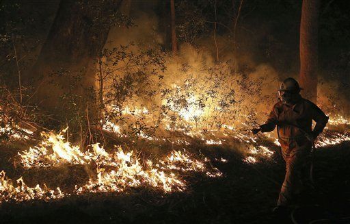
This was the scene outside Canberra a couple of weeks ago... since then Australia has gone deeper into Summer and temperatures have plunged to freezing.
Parts of southern New South Wales and the Australian Capital Territory endured their coldest November night in over forty years, with the region set to chill again tonight.

The ACT saw some of the coldest temperatures, with Canberra Airport dipping to -1.5 degrees, its coldest November night since 1970. Tuggeranong fell to a chilly 1.2 degrees, its coldest November night in a decade.

In NSW, Goulburn Airport dipped to -3.1 degrees and Thredbo -6.1 degrees, the coldest November night since 2006.

The unseasonably cold night was caused by a variety of factors. Firstly, a gusty cold front moved across the region yesterday, leaving behind a pool of cold air. Overnight, a high pressure system moved in, causing winds to ease as well as clear skies, allowing the mercury to plummet.

This high will continue to bring similar conditions tonight, allowing for the region to shiver through another cold night.

Canberra is expected to see it dip to zero tonight, and if this occurs, will be the coldest pair of November nights on record. Thredbo is expected to reach minus five, which would be its coldest pair of November nights since 2006.

Snowflake

The coming of a new Ice Age

Image
Contrary to the conventional wisdom of the day, the real danger facing humanity is not global warming, but more likely the coming of a new Ice Age. What we live in now is known as an interglacial, a relatively brief period between long ice ages. Unfortunately for us, most interglacial periods last only about ten thousand years, and that is how long it has been since the last Ice Age ended.

How much longer do we have before the ice begins to spread across the Earth's surface? Less than a hundred years or several hundred? We simply don't know.

Even if all the temperature increase over the last century is attributable to human activities, the rise has been relatively modest one of a little over one degree Fahrenheit - an increase well within natural variations over the last few thousand years.

While an enduring temperature rise of the same size over the next century would cause humanity to make some changes, it would undoubtedly be within our ability to adapt. Entering a new ice age, however, would be catastrophic for the continuation of modern civilization.

Comment: This article adds one more piece to the newly emerging consensus on the direction that our climate seems to be heading. Those scientists who carefully observe the reality on the ground and scrutinize the available facts see what is coming our way in the not so distant future: the return to an Ice Age.


Igloo

Global warming?... Chile hit with worst cold spell in 80 years

Iceage
© The Daily Caller
Anyone looking to get some delicious Chilean fruit this winter is going to be disappointed, as the worst frost in more than 80 years has damaged 50 million boxes of fruit exports - causing the country to declare a state of emergency in its agricultural sector.

The Chilean Fresh Fruit Exporters Association said that freezing temperatures throughout mid-September hit the country's fruit growers with the coldest frost since 1929.

Temperatures fell to an average of 19 degrees Fahrenheit for an average of seven hours in several of the Chile's growing regions, contributing to a huge drop-off in fruit exports.

Chilean growers exported about 282 million boxes of fruit last year, and experts believe that exports will fall short of that by about 50 million boxes for this year. However, when production increases are taken into account, the total frost damage to fruit production could be closer to 60 million or 65 million boxes.

The wine industry was hit hard by the frost as well.