Earthquakes
S


Bizarro Earth

USGS: Earthquake Magnitude 4.2 - Utah

Utah Quake_120412
© USGSEarthquake Location
Date-Time
Thursday, April 12, 2012 at 03:29:22 UTC

Wednesday, April 11, 2012 at 09:29:22 PM at epicenter

Time of Earthquake in other Time Zones

Location
37.811°N, 112.089°W

Depth
10.6 km (6.6 miles)

Region
UTAH

Distances
21 km (13 miles) N (360°) from Tropic, UT

27 km (17 miles) N (353°) from Cannonville, UT

29 km (18 miles) NNW (343°) from Henrieville, UT

209 km (130 miles) ENE (57°) from Mesquite, NV

328 km (204 miles) S (183°) from Salt Lake City, UT

Bizarro Earth

USGS: Earthquake Magnitude 5.9 - Off Coast of Oregon

Image
© USGS
Date-Time
Wednesday, April 11, 2012 at 22:41:47 UTC
Wednesday, April 11, 2012 at 01:41:47 PM at epicenterTime of Earthquake in other Time Zones

Location
43.593°N, 127.557°W

Depth
10.2 km (6.3 miles)

Region
OFF THE COAST OF OREGON

Distances

271 km (168 miles) W of Coos Bay, Oregon
303 km (188 miles) WSW of Newport, Oregon
317 km (196 miles) WNW of Brookings, Oregon
391 km (242 miles) WSW of SALEM, Oregon

Bizarro Earth

Big Earthquakes Strike 4 Locations Around the Globe

Big Quakes
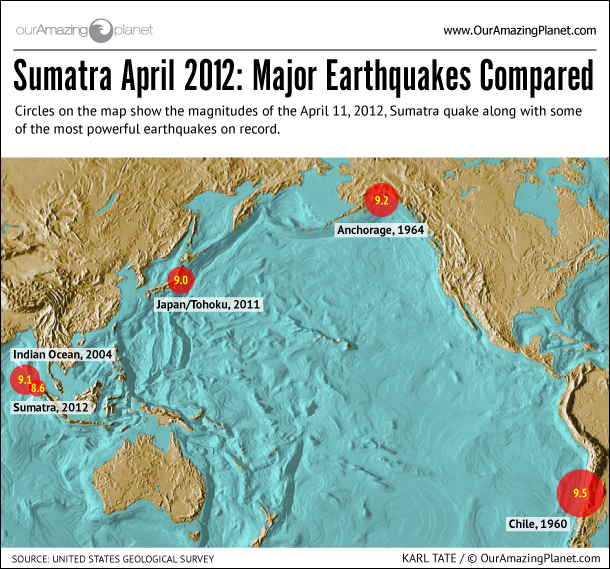
© OurAmazingPlanetThe earthquake that struck Sumatra was a big one, but , here's how it compares to some record holders.
Several earthquakes of significant strength have struck around the infamous Pacific Ring of Fire over the last few days, a not uncommon occurrence in a region prone to temblors.

First was the magnitude-8.6 earthquake that struck off the coast of the Indonesian island of Sumatra yesterday (April 11), spurring tsunami warnings and watches across the Indian Ocean basin that were later cancelled. Only a modest uptick in ocean surface heights were detected by buoys, unlike in the 2004 Indian Ocean disaster that generated a massive tsunami that killed thousands. The more recent earthquake was a different type of earthquake than the 2004 event and did not result in a large upward displacement of the ocean floor, which is typically what triggers tsunami.

Later in the day came a magnitude 6.5 earthquake on the Pacific coast of Michoacan, Mexico. It did not result in any tsunami warnings. It came a couple weeks after a magnitude 7.4 struck Oaxaca, Mexico, causing residents to evacuate buildings and causing some structural damage and minor injuries.

Bizarro Earth

USGS: Earthquake Magnitude 6.9 - Gulf of California

Image
© USGS
Date-Time:
Thursday, April 12, 2012 at 07:15:48 UTC
Thursday, April 12, 2012 at 12:15:48 AM at epicenter

Time of Earthquake in other Time Zones

Location:
28.790°N, 113.142°W

Depth:
10.3 km (6.4 miles)

Region:
GULF OF CALIFORNIA

Distances:
133 km (82 miles) NE of Guerrero Negro, Baja Calif. Sur, Mexico

179 km (111 miles) NNW of Santa Rosalia, Baja Calif. Sur, Mexico

215 km (133 miles) W of Hermosillo, Sonora, Mexico

526 km (326 miles) SSW of PHOENIX, Arizona

Bizarro Earth

Tsunami watch in Indonesia lifted after two big earthquakes

Image
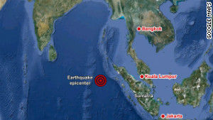
Epicenter of earthquake off the coast of northern Sumatra.
A massive earthquake struck off the coast of the Indonesian island of Sumatra on Wednesday afternoon, triggering a tsunami watch for the Indian Ocean, which was later canceled.

The quake struck about 434 kilometers (270 miles) southwest of Banda Aceh, the capital of Indonesia's Aceh province, and had a magnitude of 8.6, the U.S. Geological Survey said. It took place at a depth of 23 kilometers (14 miles).

A second large quake, with a magnitude of 8.2, occurred off the west coast of Sumatra about two hours later, the USGS said.

Gary Gibson from the Seismology Research Center in Melbourne, Australia, said the location of the second quake reduced the possibility of a tsunami.

There was also a series of smaller quakes off the west coast of northern Sumatra with magnitudes between 5.1 and 5.4.

There were no reports of destruction or deaths.

Indonesian President Susilo Bambang Yudhoyono said on local television that there were no reports of casualties or damage in Aceh.

Four people were slightly injured on Simeulue Island, off the coast of Aceh, the National Disaster Management Agency said Wednesday.

The Pacific Tsunami Warning Center issued a tsunami watch for the entire Indian Ocean. And a few hours later, the center announced the tsunami watch was canceled.

"A significant tsunami was generated by this earthquake. However, sea level readings now indicate that the threat has diminished or is over for most areas," the center said.
Radar

Tsunami - Caught On Camera

The following Channel 4 (UK) documentary captures the dreadful moments when a devastating tsunami washed away a quarter of a million people in the Indian Ocean in December 2004.


Bizarro Earth

USGS: Earthquake Magnitude 6.5 - Michoacan Mexico

Image
© USGS
Date-Time:

Wednesday, April 11, 2012 at 22:55:16 UTC

Wednesday, April 11, 2012 at 05:55:16 PM at epicenter

Time of Earthquake in other Time Zones

Location:

18.390°N, 102.652°W

Depth:

65.6 km (40.8 miles)

Region:

MICHOACAN, MEXICO

Distances:

69 km (42 miles) NW of Lazaro Cardenas, Michoacan, Mexico

129 km (80 miles) SSW of Uruapan, Michoacan, Mexico

143 km (88 miles) NW of Zihuatanejo, Guerrero, Mexico

384 km (238 miles) WSW of MEXICO CITY, D.F., Mexico

Bizarro Earth

Why Today's Indonesia Quake Didn't Make a Monster Tsunami

Indonesian Quake_110412
© USGSThe red star marks where the quake hit.

The magnitude 8.6 earthquake that struck in the Indian Ocean off the western coast of Sumatra today resurrected fears of a repeat of the 2004 Indian Ocean earthquake and tsunami that proved one of the most devastating natural disasters in modern memory.

However, this earthquake, which struck at 2:38 p.m. local time (4:38 a.m. ET), about 270 miles (435 kilometers) off the coast of the Indonesian island was a different animal altogether than the 2004 earthquake and tsunami, which killed more than 230,000 people and left millions homeless.

"It was quite a bit smaller," said Julie Dutton, a geophysicist with the U.S. Geological Survey. The 2004 quake was a magnitude 9.1 - the third most powerful earthquake ever recorded.

Perhaps more significantly, today's earthquake was a different kind of quake all together. Instead of occurring at a plate boundary along an area called a subduction zone, where one tectonic plate is diving beneath another, this earthquake occurred in the middle of an oceanic plate, where the faults in the crust essentially moved from side to side instead of up and down. These sorts of events are called strike-slip earthquakes.

"With a strike-slip event you don't have the same potential hazard for a tsunami as you do with a subduction event because the plates are moving adjacent to each other," Dutton told OurAmazingPlanet.

Bizarro Earth

Number of earthquakes more than double in Arizona in 2011

Image
© AGS
According to the Arizona Geological Survey, 131 earthquakes were detected in 2011 compared with 53 in 2010. That was twice as many as in 2009 and about a third more than in 2008. Most of the earthquakes were in the northwestern part of the state. The Yuma area was also shaken by earthquakes associated with the Gulf of California Rift Zone.

Many of these earthquakes (magnitude ca. 1.6) occurred near Lake Mead. These are attributed to mining and quarrying, and also to crustal adjustments to water going into and out of the lake. The strongest earthquakes (magnitude ca. 3.6) occurred near Clarkdale in the central part of the state. The Survey says that these events are consistent with past behavior: "a propensity for deeper seismicity to occur in two pockets, the northwestern Utah-Arizona border and well within the Colorado Plateau in the northeast corner of the state" and "the highest concentration of energy release correlates well with the pattern of established Quaternary faulting, indicating that this portion of the crust continues to be an active area of strain release and of particular interest for hazard studies in Arizona." The strain is due to on-going crustal extension.

Bizarro Earth

USGS: Earthquake Magnitude 8.6 - Off West Coast of Sumatra

Image
© USGS
Date-Time:
Wednesday, April 11, 2012 at 08:38:37 UTC
Wednesday, April 11, 2012 at 02:38:37 PM at epicenter

Time of Earthquake in other Time Zones

Location:
2.311°N, 93.063°E

Depth:
22.9 km (14.2 miles)

Region:
OFF THE WEST COAST OF NORTHERN SUMATRA

Distances:
434 km (269 miles) SW of Banda Aceh, Sumatra, Indonesia

550 km (341 miles) SW of Lhokseumawe, Sumatra, Indonesia

963 km (598 miles) W of KUALA LUMPUR, Malaysia

1797 km (1116 miles) WNW of JAKARTA, Java, Indonesia