Earthquakes
S


Bizarro Earth

Vanuatu - Earthquake Magnitude 6.0 - 5th Feb 12

Vanuatu Quake_1050212
© USGSEarthquake Location
Date-Time:
Sunday, February 05, 2012 at 16:40:38 UTC

Monday, February 06, 2012 at 03:40:38 AM at epicenter

Time of Earthquake in other Time Zones

Location:
17.950°S, 167.170°E

Depth:
4.3 km (2.7 miles) (poorly constrained)

Region:
VANUATU

Distances:
123 km (76 miles) WSW of PORT-VILA, Efate, Vanuatu

267 km (165 miles) S of Luganville, Espiritu Santo, Vanuatu

283 km (175 miles) NW of Isangel, Tanna, Vanuatu

1795 km (1115 miles) ENE of BRISBANE, Queensland, Australia

Bizarro Earth

Vanuatu - Earthquake Magnitude 6.1

Vanuatu Quake_050212
© USGSEarthquake Location
Date-Time:
Sunday, February 05, 2012 at 00:15:40 UTC

Sunday, February 05, 2012 at 11:15:40 AM at epicenter

Time of Earthquake in other Time Zones

Location:
18.935°S, 168.923°E

Depth:
163.4 km (101.5 miles)

Region:
VANUATU

Distances:
77 km (47 miles) NNW of Isangel, Tanna, Vanuatu

147 km (91 miles) SSE of PORT-VILA, Efate, Vanuatu

309 km (192 miles) NNE of Tadine, Loyalty Islands, New Caledonia

1882 km (1169 miles) ENE of BRISBANE, Queensland, Australia

Bizarro Earth

Canada: Earthquake Magnitude 5.7 - Vancouver Island

Image
© USGS
Date-Time:
Saturday, February 04, 2012 at 20:05:32 UTC
Saturday, February 04, 2012 at 12:05:32 PM at epicenter
Time of Earthquake in other Time Zones

Location:
48.867°N, 127.876°W

Depth:
12.8 km (8.0 miles)

Region:
VANCOUVER ISLAND, CANADA REGION

Distances:
170 km (105 miles) W of Ucluelet, British Columbia, Canada

206 km (128 miles) S of Port Hardy, British Columbia, Canada

229 km (142 miles) WSW of Campbell River, British Columbia

Bizarro Earth

Vanuatu: Earthquake Magnitude 6.0 - 2nd Feb 2012

Vanuatu Quake_030212
© USGSEarthquake Location
Date-Time:
Friday, February 03, 2012 at 03:46:23 UTC

Friday, February 03, 2012 at 02:46:23 PM at epicenter

Time of Earthquake in other Time Zones

Location:
17.376°S, 167.278°E

Depth:
21.7 km (13.5 miles)

Region:
VANUATU

Distances:
116 km (72 miles) WNW of PORT-VILA, Efate, Vanuatu

204 km (126 miles) S of Luganville, Espiritu Santo, Vanuatu

318 km (197 miles) NW of Isangel, Tanna, Vanuatu

1844 km (1145 miles) NE of BRISBANE, Queensland, Australia

Bizarro Earth

Vanuatu: Earthquake Magnitude 7.1 - West of Efate

Image
© USGS
Date-Time:
Thursday, February 02, 2012 at 13:34:38 UTC

Friday, February 03, 2012 at 12:34:38 AM at epicenter

Time of Earthquake in other Time Zones

Location:
17.810°S, 167.149°E

Depth:
10.1 km (6.3 miles)

Region:
VANUATU

Distances:
124 km (77 miles) W of PORT-VILA, Efate, Vanuatu

251 km (155 miles) S of Luganville, Espiritu Santo, Vanuatu

294 km (182 miles) NW of Isangel, Tanna, Vanuatu

1803 km (1120 miles) ENE of BRISBANE, Queensland, Australia

Bizarro Earth

Near the Coast of Central Peru - Earthquake Magnitude 6.3

Peru Quake_300112
© USGSEarthquake Location
Date-Time
Monday, January 30, 2012 at 05:11:00 UTC

Monday, January 30, 2012 at 12:11:00 AM at epicenter

Time of Earthquake in other Time Zones

Location
14.179°S, 75.644°W

Depth
39.2 km (24.4 miles)

Region
NEAR THE COAST OF CENTRAL PERU

Distances
15 km (9 miles) SE of Ica, Peru

96 km (59 miles) SSE of Chincha Alta, Peru

172 km (106 miles) WNW of Puquio, Peru

280 km (173 miles) SSE of LIMA, Peru

Bizarro Earth

5.7 quake strikes remote Pacific area: geologists

Wellington: A 5.7-magnitude earthquake and several aftershocks struck beneath the Pacific off New Zealand's Kermadec Islands today, US geologists said, but no tsunami warning was issued.

The remote offshore quake hit at 05:42am local time at a depth of 32 kilometres, 65 kilometres east of Raoul Island and 926 kilometres south of Tonga, the United States Geological Survey (USGS) said.

The USGS at first measured the quake at a strong magnitude of 6.2 but later downgraded it.

Bizarro Earth

Active 200-km Fault Found off Honshu's Kii Peninsula

New Fault Line
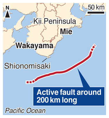
© Kyodo Graphic
Kyodo - An active fault around 200 km long that is believed to have been a source of huge quakes in the past has been found off Honshu's Kii Peninsula, according to researchers at the University of Tokyo.

If the fault on the Nankai Trough moves, it could trigger a magnitude 8.0 earthquake, the researchers said, adding they have found a seabed cliff several hundred meters high that was created by the fault's past movements.

"There is a high probability that fault shifts have caused great tsunami," said Park Jin Oh, associate professor of marine geology. "We need to reformulate disaster countermeasures by taking into account an active fault on the seabed 200 km or longer."

Park analyzed sonar data on the seabed collected by the Japan Agency for Marine-Earth Science and Technology and found a fault branching off from a boundary between two tectonic plates in an area west of the southern tip of the Kii Peninsula in Wakayama Prefecture.

The fault was found to be connected to a similar fault to the east of the peninsula and to extend at least 200 km, the researchers said.

Bizarro Earth

Kermadec Islands - Earthquake Magnitude 5.8

Kermadec Quake_280112
© USGSEarthquake Location
Date-Time
Saturday, January 28, 2012 at 17:42:53 UTC

Sunday, January 29, 2012 at 05:42:53 AM at epicenter

Time of Earthquake in other Time Zones

Location
29.344°S, 177.424°W

Depth
28 km (17.4 miles)

Region
KERMADEC ISLANDS, NEW ZEALAND

Distances
47 km (29 miles) E of Raoul Island, Kermadec Islands

272 km (169 miles) NNE of L'Esperance Rock, Kermadec Islands

936 km (581 miles) SSW of NUKU'ALOFA, Tonga

1108 km (688 miles) NE of Auckland, New Zealand

Bizarro Earth

California, US: No damage preliminary 3.4 quake hits near Sonoma

San Francisco - No damage has been reported after an earthquake with a preliminary magnitude of 3.4 rattled a rural area of Northern California.

The U.S. Geological Survey says the quake hit at 9:21 p.m. Thursday about 26 miles north of Santa Rosa, or about 75 miles north of San Francisco.