Earthquakes
S


Radar

Earthquake Magnitude 5.9 - Tonga

Image
Date-Time

Saturday, October 08, 2011 at 08:53:12 UTC
Saturday, October 08, 2011 at 09:53:12 PM at epicenter
Time of Earthquake in other Time Zones

Location 20.543°S, 173.189°W

Depth 6.5 km (4.0 miles)

Region TONGA

Distances 216 km (134 miles) ENE of NUKU'ALOFA, Tonga
221 km (137 miles) SSE of Neiafu, Tonga
388 km (241 miles) WSW of Niue Island
2155 km (1339 miles) NE of Auckland, New Zealand

Radar

Magnitude 5.6 quake jolts northeastern Japan

A strong earthquake with a preliminary magnitude of 5.6 jolted northeastern Japan on Monday, public broadcaster NHK said. The quake, at 11:46 a.m. (10:46 p.m. ET), was also felt in Tokyo.

There were no immediate reports of injuries or damage and no tsunami warning was issued.

Bizarro Earth

US: Pennsylvania - Swatara Township asking geological experts to investigate explosion-like shaking

Swatara Township officials have requested the assistance of the U.S. Geological Survey and other experts to investigate a shaking -- that feels like explosions -- that people near the township building are reporting.

There are no major construction projects, and the shaking seems to be located right around the township building, according to officials.

Image
© Unknown

Comment: The reader may be interested in the Comments from the locals at the bottom of the article.


Bizarro Earth

South of Kermadec Islands - Earthquake Magnitude 6.1

Kermadec Quake_071011
© USGSEarthquake Location
Date-Time:
Friday, October 07, 2011 at 08:58:29 UTC

Friday, October 07, 2011 at 08:58:29 PM at epicenter

Time of Earthquake in other Time Zones

Location:
32.389°S, 178.902°W

Depth:
40 km (24.9 miles)

Region:
SOUTH OF THE KERMADEC ISLANDS

Distances:
106 km (65 miles) S of L'Esperance Rock, Kermadec Islands

359 km (223 miles) SSW of Raoul Island, Kermadec Islands

762 km (473 miles) NE of Auckland, New Zealand

1136 km (705 miles) NNE of WELLINGTON, New Zealand

Bizarro Earth

Micronesia: Earthquake Magnitude 5.8 - State of Yap

Image
© USGS
Date-Time:
Thursday, October 06, 2011 at 07:37:03 UTC

Thursday, October 06, 2011 at 05:37:03 PM at epicenter

Time of Earthquake in other Time Zones

Location:
9.712°N, 138.292°E

Depth:
35.7 km (22.2 miles)

Region:
STATE OF YAP, FED. STATES OF MICRONESIA

Distances:
27 km (16 miles) NE of Yap, Micronesia

493 km (306 miles) ENE of KOROR, Palau

818 km (508 miles) WSW of HAGATNA, Guam

899 km (558 miles) WSW of Rota, Northern Mariana Islands

Bizarro Earth

Argentina: Earthquake Magnitude 6.2 - Jujuy

Image
© USGS
Date-Time:
Thursday, October 06, 2011 at 11:12:29 UTC

Thursday, October 06, 2011 at 08:12:29 AM at epicenter

Time of Earthquake in other Time Zones

Location:
24.181°S, 64.250°W

Depth:
9.5 km (5.9 miles)

Region:
JUJUY, ARGENTINA

Distances:
106 km (65 miles) E of San Salvador de Jujuy, Jujuy, Argentina

129 km (80 miles) N of El Quebrachal, Salta, Argentina

135 km (83 miles) ENE of Salta, Salta, Argentina

1274 km (791 miles) NNW of BUENOS AIRES, D.F., Argentina

Bizarro Earth

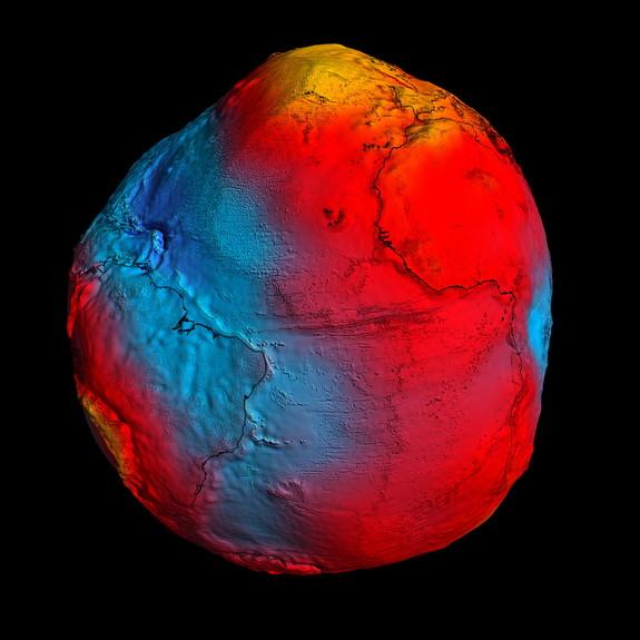
Massive Japan Earthquake Altered Earth's Gravity

Geoid
© ESA/HPF/DLRESA's GOCE mission has delivered the most accurate model of the 'geoid' ever produced. Red corresponds to points with higher gravity, and blue to points with lower gravity.
The devastating earthquake that struck Japan earlier this year was powerful enough to slightly alter the pull of gravity under the affected area, scientists now find.

Anything that has mass has a gravity field that attracts objects toward it. The strength of this field depends on a body's mass. Since the Earth's mass is not spread out evenly, this means its gravity field is stronger in some places and weaker in others.

The magnitude 9.0 Tohoku-Oki temblor in March was the most powerful earthquake to hit Japan and the fifth-most powerful quake ever recorded. To see how the temblor might have deformed the Earth there, scientists used the Gravity Recovery and Climate Experiment (GRACE) satellites to analyze the area's gravity field before and after the quake.

The researchers found the Tohoku-Oki quake reduced the gravity field there by an average of two- millionths of a gal by slightly thinning the Earth's crust. In comparison, the strength of the gravitational pull at the Earth's surface is, on average, 980 gals. (The gal, short for Galileo, is a unit of acceleration; one gal is defined as one centimeter per second squared.)

Bizarro Earth

Earthquake swarm after officials confirm eruption at Iceland volcano Katla

Image
© UnknownIs Katla about to erupt again?
Iceland's massive volcano Katla appears on the brink of a major eruption just days after officials confirmed they had detected the start of eruptions over the summer.

Measuring devices this morning have picked up a large earthquake swarm, usually a tell-tale sign of a potential volcanic eruption.

The Icelandic Government last month announced it was increasing monitoring Katla, which is one of Europe's most feared volcanoes, following a consistent and strengthening spike of tremors and quakes.

And last week, officials at the Iceland Meteorological Office confirmed a series of smaller eruptions had occurred in July strengthening fears of an imminent, much larger, eruption.

Evidence gathered by geophysicists showed the magma had risen to the height of the glacier ice above the volcano causing it to melt.

They said the high seismic tremors recorded on July 8 and 9 confirmed Katla had become active and started small eruptions.
Bizarro Earth

Rare Subsea Earthquakes Rattle Bermuda

The western Atlantic Ocean island of Bermuda, which was hit by its first earthquake in over a decade in April, has been rattled by two moderate quakes.

The earthquakes, both measuring 4.5 magnitude on the Richter Scale, struck at 10:18 PM and 10:36 PM local time on Monday.

Image
© Google EarthEpicentre of Monday night's earthquakes
The subsea quakes, the strongest to be recorded in the region in more than 20 years, were centred about 80 miles (130 km) south of Hamilton, the capital of the British overseas territory.

According to the United States Geological Survey (USGS), the quakes (1st, 2nd) occurred at depths ranging between 10 and 14 kilometres.

Radar

Philippines: Earthquake Magnitude 5.0 - Mindanao

Image
Date-Time:
Sunday, October 02, 2011 at 09:19:25 UTC

Sunday, October 02, 2011 at 05:19:25 PM at epicenter

Time of Earthquake in other Time Zones

Location:
8.385°N, 126.723°E

Depth:
46.9 km (29.1 miles)

Region:
MINDANAO, PHILIPPINES

Distances:
43 km (26 miles) E of Hinatuan, Mindanao, Philippines

143 km (88 miles) ESE of Butuan, Mindanao, Philippines

864 km (536 miles) W of KOROR, Palau

929 km (577 miles) SE of MANILA, Philippines