Earthquakes
S


Seismograph

6.1-magnitude earthquake hits off Solomon Islands

nnnn
An earthquake with a magnitude of 6.1 jolted 73 km W of Buala, Solomon Islands, at 22:19:15 GMT on Monday, the U.S. Geological Survey said.

The epicenter, with a depth of 85.976 km, was initially determined to be at 8.2105 degrees south latitude and 158.9268 degrees east longitude.

Seismograph

6.5 magnitude earthquake strikes Jujuy, Argentina

mmmmmmm
An earthquake measuring 6.5 magnitude struck Jujuy, Argentina on Wednesday, the European Mediterranean Seismological Centre said.

The quake struck at a depth of 200 km (124.27 miles), EMSC said.

Source: Reuters

Seismograph

At least 13 deaths reported as powerful magnitude 6.5 earthquake rocks Afghanistan, Pakistan and India (UPDATE)

mmmmm
An magnitude 6.5 earthquake struck northern Afghanistan on Tuesday evening, killing at least one person in neighbouring Pakistan and causing strong shaking across the north in both countries.

The tremor was very deep, 194 km, and its epicentre was in the Hindu Kush mountain range, near the remote northern Afghan province of Badakhshan.

A 13-year old girl died when a wall in her home collapsed on her, and 34 people were injured in the northern Pakistani district of Swat, police officer Shafiullah Gandapur told Reuters.

Disaster authorities in Afghanistan said they did not have any immediate reports of casualties.


Comment: Update March 22

The Evening Standard reports:
At least 13 people were killed and more than 90 injured in Pakistan and Afghanistan after a magnitude 6.5 earthquake struck late on Tuesday.

Millions felt the tremors rattle the South Asian region late on Tuesday, sending terrified residents fleeing from homes and offices.

At least nine people died in Pakistan and four in Afghanistan.

The quake was felt over an area more than 1,000 kilometres (621 miles) wide by some 285 million people in Pakistan, India, Uzbekistan, Tajikistan, Kazakhstan, Kyrgyzstan, Afghanistan and Turkmenistan, the European-Mediterranean Seismological Centre said.

The epicentre was in the Hindu Kush mountains, in the sparsely populated northeastern Afghan province of Badakhshan, 40km southeast of Jurm village, at the considerable depth of 187km, the US Geological Survey said.

In Pakistan's Khyber Pakhtunkhwa province senior provincial official Abdul Basit said that in addition to the dead and injured, at least 19 houses were damaged.

Shafiullah Rahimi, a spokesperson for Afghanistan's disaster mitigation ministry, said late on Tuesday that two people had been killed in the eastern province of Laghman.

Large parts of South Asia are seismically active because a tectonic plate known as the Indian plate is pushing north into the Eurasian plate.

A 6.1 magnitude earthquake in eastern Afghanistan killed more than 1,000 people last year.

In 2005, at least 73,000 people were killed by a 7.6 magnitude quake that struck northern Pakistan.


Seismograph

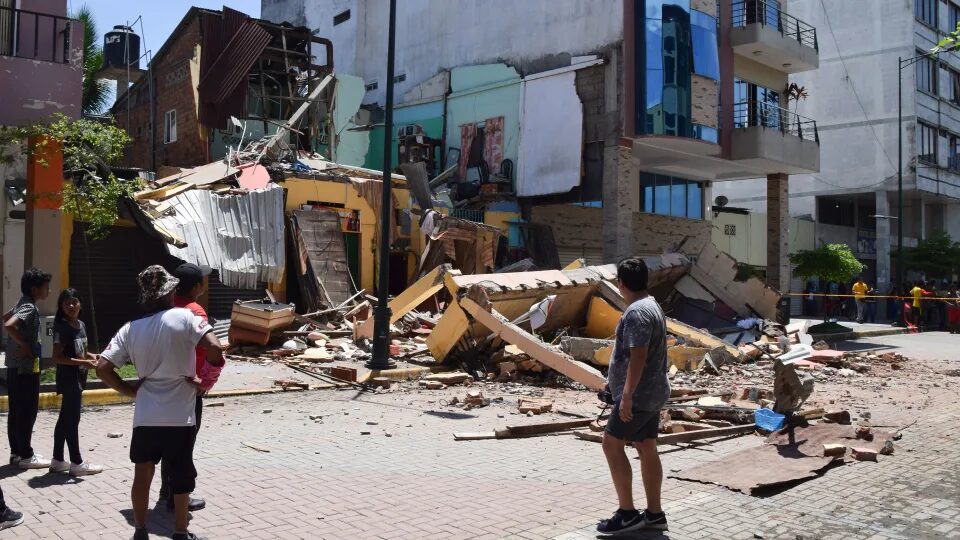
At least 16 dead after magnitude 6.8 earthquake shakes Ecuador

Residents look at a building that collapsed after an earthquake struck Machala, Ecuador, on March 18, 2023.
© Jhonny Crespo/APResidents look at a building that collapsed after an earthquake struck Machala, Ecuador, on March 18, 2023.
At least 16 people died after a magnitude 6.8 earthquake struck southern Ecuador on Saturday afternoon, according to government officials.

The earthquake struck near the southern town of Baláo and was more than 65 km (nearly 41 miles) deep, according to the United States Geological Survey.

An estimated 381 people were injured in the quake, the General Secretariat of Communication of the Presidency of Ecuador tweeted on their official account.

In the province of El Oro, at least 11 people died. At least one other death was reported in the province of Azuay, according to the communications department for Ecuador's president. In an earlier statement, authorities said the person in Azuay was killed when a wall collapsed onto a car and that at least three of the victims in El Oro died when a security camera tower came down.


Seismograph

Shallow 7.0-magnitude earthquake hits Kermadec Islands, causes small tsunami

nnnnnnnnn
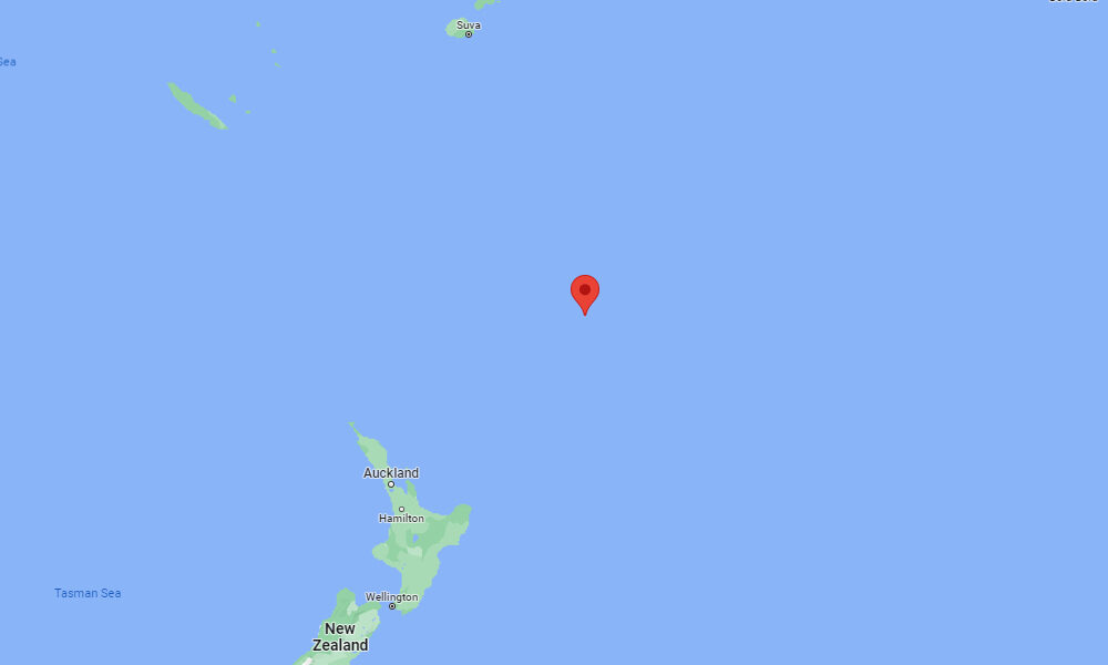
The epicenter of the earthquake
A powerful 7.0-magnitude earthquake has struck the Pacific Ocean near the Kermadec Islands, far north of New Zealand's mainland, seismologists say. Small tsunami waves were observed at a nearby island.

The earthquake, which struck at 1:56 p.m. local time on Thursday, was centered about 195 kilometers (121 miles) southeast of Raoul Island, the largest of the Kermadec Islands, or 1,125 kilometers (700 miles) northeast of Auckland.

The U.S. Geological Survey said the earthquake had a preliminary magnitude of 7.0, down from 7.1 in an earlier assessment. It struck about 22 kilometers (14 miles) below the seabed, making it a shallow earthquake.

Tsunami alerts - which were initially issued for the Kermadec Islands, Fiji, New Zealand and Tonga - were canceled when it was determined there was no longer a threat.
Seismograph

6.3 magnitude earthquake strikes eastern Papua New Guinea

mmmmmmmm
An earthquake measuring 6.3 magnitude on the Richter scale has struck eastern Papua New Guinea.

The European-Mediterranean Seismological Centre (EMSC) said that the epicentre of the earthquake occurred at a depth of 211 km, 456 km northwest of the capital, Port Moresby.

There were no reports of casualties or material damage due to the earthquake.

Papua New Guinea is located along the Pacific Ring of Fire, a region that extends along the coasts of the Pacific Ocean, and is characterised by high activity of earthquakes and volcanoes.

The last earthquake struck northwest of the Kimbe town in Papua New Guinea on Mar 1, with a magnitude of 6.5 without causing material damage or human losses.

Seismograph

Shallow 6.0-magnitude earthquake hits off Papua New Guinea - USGS

mmmm
An earthquake with a magnitude of 6.0 jolted 72 km SSW of Kavieng, Papua New Guinea at 13:51:49 GMT on Tuesday, the U.S. Geological Survey said.

The epicenter, with a depth of 10.0 km, was initially determined to be at 3.2132 degrees south latitude and 150.6471 degrees east longitude.

Seismograph

6.0-magnitude earthquake rocks southern Philippines

mmmmmmm
A 6.0-magnitude earthquake jolted the southern Philippines on Tuesday (Mar 7), the US Geological Survey said, but there were no reports of casualties or major damage.

The shallow quake struck at about 2pm local time (0600 GMT), a few kilometres from Maragusan municipality in the mountainous gold-mining province of Davao de Oro on Mindanao island.

Shallow earthquakes tend to cause more harm than deeper ones, but local authorities said there were no reports of major damage.

Cherrylyn Dapiton of the Maragusan disaster office confirmed there had been a landslide near a road, but it had not affected anyone or blocked traffic.

Seismograph

6.9 magnitude earthquake strikes Kermadec Islands

mmmm
An earthquake of magnitude 6.9 struck the Kermadec Islands region in New Zealand on Saturday, the United States Geological Survey (USGS) said.

The quake was at a depth of 152 km (94 miles), USGS said.

The European Mediterranean Seismological Centre earlier estimated the magnitude at 6.6 and a depth at 183 km.

No tsunami warning was issued after the quake, the US Tsunami Warning System said.

Source: Reuters

Seismograph

Vanuatu: Pacific nation reels from twin cyclones and 6.5 magnitude earthquake

mmmmmm
The Pacific nation of Vanuatu has declared a state of emergency as it reels from an earthquake and two cyclones in as many days.

The 6.5 magnitude quake struck on Friday, a day after category four Cyclone Judy swept through the islands.

The storm caused widespread damage and flooding across the country. No casualties have been reported yet.

A category three storm, Cyclone Kevin, arrived on Friday, bringing destructive winds of up to 130km/h (81mph).