Earth ChangesS


Cloud Lightning

1 million evacuated as typhoon Morakot hits China

Morakot 3
© Sam Yeh/AFP/Getty Images Local residents trapped by flooding during typhoon Morakot wait for help from rescuers, in Chiatung, Pingtung county, Taiwan, Aug. 9, 2009.
A typhoon slammed into China's east coast Sunday, flooding entire villages, destroying homes and forcing the evacuation of nearly a million residents, after lashing Taiwan with torrential rains that caused the island's worst flooding in 50 years.

Rescuers on rubber dinghies, wearing life jackets and crash helmets, helped stranded villagers in hard-hit areas of China, while officials elsewhere cycled through floodwaters to deliver food to residents trapped in their homes.

Only rooftops and the highest tree branches were visible above the murky brown water that engulfed part of China's southern Cangnan county. Homes were destroyed and at least one child died after a house collapsed on him in heavy rain in Zhejiang province.

In southern Taiwan, a six-story hotel toppled into a rain-swollen river whose rushing waters had knocked out its foundations.
Bizarro Earth

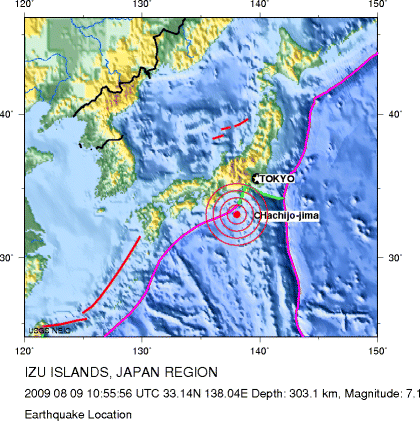
Magnitude 7.1 earthquake strikes Japan coast

Image
© US Geological Survey
A strong earthquake struck off the south coast of Japan on Sunday night local time, "jolting Tokyo and wide areas of eastern Japan," the country's Kyodo news agency reported.

The 7.1 earthquake hit 200 miles (320 kilometers) south-southwest of Tokyo at 7:55 p.m. (6:55 a.m. ET), the United States Geological Survey reported.

Its epicenter was 188 miles (303 kilometers) deep, the USGS said.

The Japan Meteorological Agency reported its magnitude as 6.9, Kyodo said.

There were no immediate reports of damage, and the Pacific Tsunami Warning Center did not issue a tsunami warning

Bizarro Earth

India: 43 feared dead in Uttarakhand landslides

At least 43 people were feared dead and several others injured in massive landslides caused by heavy rains in three hilly villages of Pithoragarh district of Uttarakhand on Friday morning. The villages - Jhetalan, Laa, and Maati - situated at a height of 6000 feet and 65 km north of Pithoragarh, were washed away by the massive slides at around 2 am, district magistrate N S Negi said.

"The impact of the rains was so heavy that a whole mountain came sliding down on the three villages, instantly destroying several dwellings," Minister for Planning, Labour, and Parliamentary Affairs Minister Prakash Pant told HT.

Bizarro Earth

Long debate ended over cause, demise of ice ages - may also help predict future

A team of researchers says it has largely put to rest a long debate on the underlying mechanism that has caused periodic ice ages on Earth for the past 2.5 million years - they are ultimately linked to slight shifts in solar radiation caused by predictable changes in Earth's rotation and axis.

In a publication to be released Friday in the journal Science, researchers from Oregon State University and other institutions conclude that the known wobbles in Earth's rotation caused global ice levels to reach their peak about 26,000 years ago, stabilize for 7,000 years and then begin melting 19,000 years ago, eventually bringing to an end the last ice age.

The melting was first caused by more solar radiation, not changes in carbon dioxide levels or ocean temperatures, as some scientists have suggested in recent years.

Cloud Lightning

Typhoon Morakot hits Philippines; threatens Taiwan

At least eight people were killed as Typhoon Morakot swamped the northern Philippines with flooding, the National Disaster Coordinating Council said Friday.

The casualties include several international tourists who had returned from a trip to Mt. Pinatubo, the Philippine Daily Inquirer reported.

The destructive path of Morakot, also called Typhoon Koko, included Taiwan and South China. The storm was expected to bring its strong winds and the threat of soaking the island when it makes its expected landfall late Friday or early Saturday, CNN reported.

The typhoon, with wind gusts clocked at 120 mph, could dump between 40 inches and 50 inches of rain, CNN meteorologists said.

Bizarro Earth

Earthquake Magnitude 4.9 - Offshore Northern California

Image
© USGS
Date-Time:
Friday, August 07, 2009 at 10:49:34 UTC
Friday, August 07, 2009 at 03:49:34 AM at epicenter

Location:
40.316°N, 124.626°W

Depth:
16.4 km (10.2 miles)

Region:
Offshore Northern California

Distances:
29 km (18 miles) W (268°) from Petrolia, CA

42 km (26 miles) SW (227°) from Ferndale, CA

48 km (30 miles) WSW (245°) from Rio Dell, CA

66 km (41 miles) SW (217°) from Eureka, CA

334 km (208 miles) NW (307°) from Sacramento, CA

Bizarro Earth

3.3. Earthquake Shakes the Los Angeles Area

A small earthquake rattled the Los Angeles area early this morning.

The magnitude-3.3 quake struck around 1:53 a.m. Friday and was centered about 4 miles north-northwest of Fontana and 44 miles east of the Los Angeles Civic Center, according to a preliminary report by the U.S. Geological Survey.

The survey says the earthquake's epicenter was relatively shallow, just one-tenth of a mile below the surface.

There were no immediate reports of damage or injury.

Ladybug

The plight of the humble bee

Honeybees are in serious trouble. Last year nearly a third of the UK's 240,000 honeybee colonies were wiped out, putting at risk the pollination of fruits and vegetables. Early indications of losses this year suggest the bees are faring slightly better, but a survey of beekeepers to be released this month is expected to show that around one in five hives didn't make it through the winter. Beekeepers can usually expect to lose 10% of their hives due to poor weather or disease.

Alarm Clock

King salmon vanishing in Alaska, smokehouses empty

Anchorage - Yukon River smokehouses should be filled this summer with oil-rich strips of king salmon - long used by Alaska Natives as a high-energy food to get through the long Alaska winters. But they're mostly empty.

The kings failed to show up, and not just in the Yukon.

Cloud Lightning

Typhoon Morakot's cloud top extent doubled in size in one day

Satellite imagery over the last two days has shown Typhoon Morakot to be a monster, and over the last two days, NASA satellites have confirmed the typhoon doubled its size!

Image
© NASA JPL, Ed OlsenThis infrared satellite image shows Typhoon Morakot's cold clouds (depicted in purple and blue) stretching over 1,000 miles in diameter on Aug. 6 in the East China Sea.
"Our satellite scan swath width is 1700 kilometers (1,056 miles) and Morakot looks to be almost that much in diameter in the infrared imagery on August 5," said Ed Olsen, of NASA's Jet Propulsion Laboratory in Pasadena, Calif. Olsen provides images for the Atmospheric Infrared Sounder (AIRS) instrument on the Aqua satellite. "On August Morakot was only about 1/2 the width of our swath width, near 850 kilometers (528 miles) in diameter!"

To put it into perspective, 1,056 miles is longer than the distance from Philadelphia, Pennsylvania to Orlando, Florida. Olsen said that it's important to know that satellite image represents the lateral extent of the cold cloud tops and that the winds definitely do not extend over an area 1,000 miles in diameter.