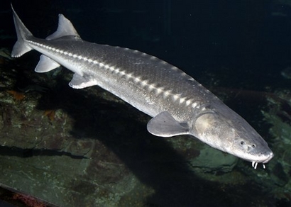
© AP Photo/Monterey Bay Aquarium, Randy WildeThis undated image provided by the Monterey Bay Aquarium, shows the endangered Kootenai River white sturgeon. As efforts falter to save this largest freshwater fish — a toothless beast left over from the days of dinosaurs — officials hope to stave off extinction by sending more water hurtling down a river so the fish can spawn in the wild.
Billings, Montana. - As efforts falter to save North America's largest freshwater fish - a toothless beast left over from the days of dinosaurs - officials hope to stave off extinction by sending more water hurtling down a river so the fish can spawn in the wild.
The U.S. Fish and Wildlife Service on Thursday declared that attempts over the past two years to save the endangered Kootenai River white sturgeon had failed.
The prehistoric sturgeon, characterized by its large head and armor-like scales, can reach 19 feet long and top 1,000 pounds.
An isolated population of the species lives along a stretch of the Kootenai that passes through Montana, northern Idaho and southern British Columbia. Fewer than 500 of the bottom-feeding behemoths survive - and it's been 35 years since they successfully spawned.
The problem is Libby Dam, a hydroelectric facility in Montana run by the Army Corps of Engineers that serves power markets in the Pacific Northwest. When the dam went up in 1974, it stopped periodic flooding of Bonners Ferry, Idaho - but also high water flows that triggered the sturgeon to move upriver and spawn.
XinhuaSat, 26 Dec 2009 14:47 UTC
An earthquake measuring 6.0 on the Richter scale hit off Banda Sea, Indonesia, at 17:04 p.m. ( 0904 GMT) Saturday, according to a bulletin released by the Hong Kong Observatory.
The epicenter was initially determined to be at 5.6 degrees south latitude and 131.1 degrees east longitude, about 390 km east- southeast of Ambon, Indonesia.
Bullit Marquez
PhysOrgSat, 26 Dec 2009 06:00 UTC
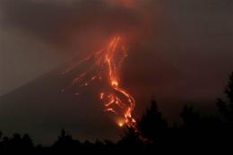
© AP Photo/Bullit MarquezLava flows continuously from the crater of Mayon volcano in a continuing mild eruption as viewed from Sto. Domingo township, Albay province, about 500 kilometers southeast of Manila, Philippines.
Fewer earthquakes have been recorded in the Philippines' lava-spilling Mayon volcano, but magma continues to build up inside and any lull in activity could be followed by a bigger eruption, scientists said Saturday.
A hazardous eruption remains possible within days, and residents who live near the volcano's slopes should not be misled into leaving the evacuation centers that they spend Christmas in and venturing back to their homes, volcanologist Ed Laguerta warned.
"The number of volcanic earthquakes has gone down, but this is just part of the eruptive cycle of Mayon," he said.
The number of quakes decreased from 871 recorded during the 24-hour period ending Friday morning to 406 recorded during the next 24 hours, the Philippine Institute of Volcanology and Seismology said.
Large shipping vessels have become commonplace in today's global marketplace as goods are imported and exported across the world. While the high levels of pollution they create are something that most people don't think too much about, some scientists are beginning to evaluate their environmental effect. One of the most disturbing facts discovered about these giant ships is that a mere 16 of them emit as much sulfur as do all the cars in the world combined.
Fred Pearce, a science writer and environmental consultant for New Scientist, has been studying the shipping industry for quite some time. He has focused particularly on their use of filthy, toxic fuel that is polluting the air at a staggering pace. According to his assessment, thousands of people die every year from the toxic fumes that are emitted from their smokestacks, lingering in the air as a brown haze for many days. If current practices continue, he estimates that upwards of a million people will die in the next decade due to ship pollution.
Earth's north magnetic pole is
racing toward Russia at almost 40 miles (64 kilometers) a year due to magnetic changes in the planet's core, new research says.
The core is too deep for scientists to directly detect its magnetic field. But researchers can infer the field's movements by tracking how Earth's magnetic field has been changing at the surface and in space.
Now, newly analyzed data suggest that there's a region of rapidly changing magnetism on the core's surface, possibly being created by a mysterious "plume" of magnetism arising from deeper in the core.
Short of a catastrophic asteroid impact, the greatest threat to the human race is the onset of another ice age.... Global warming predictions by meteorologists are based on speculative, untested, and poorly constrained computer models.... our knowledge of ice ages is based on a wide variety of reliable data, including cores from the Greenland and Antarctic ice sheets. ... By reducing our production of carbon dioxide, we risk hastening the advent of the next ice age. Even more foolhardy and dangerous is the Obama administration's announcement that they may try to cool the planet through geoengineering. Such a move in the middle of a cooling trend could provoke the irreversible onset of an ice age. It is not hyperbole to state that such a climatic change would mean the end of human civilization as we know it.
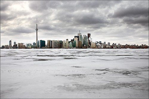
Our near future?
Those who ignore the geologic perspective do so at great risk. In fall of 1985, geologists warned that a Columbian volcano, Nevado del Ruiz, was getting ready to erupt. But the volcano had been dormant for 150 years. So government officials and inhabitants of nearby towns did not take the warnings seriously.
On the evening of November 13, Nevado del Ruiz erupted, triggering catastrophic mudslides. In the town of Armero, 23,000 people were buried alive in a matter of seconds.
For ninety percent of the last million years, the normal state of the Earth's climate has been an ice age. Ice ages last about 100,000 years, and are punctuated by short periods of warm climate, or interglacials. The last ice age started about 114,000 years ago. It began instantaneously.
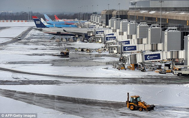
© AFP/Getty ImagesTractors remove snow from the ground at Manchester Airport
- Temperatures plunge to -16C in Scotland and -9C in England
- 12million drivers expecting to begin Christmas getaways today
- AA attends about 3,000 breakdowns since midnight across the UK
- EasyJet cancels at least 20 flights in and out of London airports
- Nine weather-related deaths reported across Britain since Monday
Nine people have died and millions face Christmas travel chaos as Britain endures freezing temperatures colder than Alaska.
The mercury plunged to -16C overnight in Tulloch, Aberdeenshire - the coldest place in the UK - while the Hampshire village of Odiham recorded England's lowest temperature of -9.6C.
The continuing freezing weather comes as 12million drivers in the UK are expected to attempt to travel to family and friends for Christmas, staggered over today and tomorrow.
Part 1: A Hot PotatoVery few of us understand climate or weather. Most of us have taken a blind faith approach to researching these subjects. Unfortunately, this will be to the great detriment of all of humanity.
This broadcast segment is about the urgent need for verifiable facts about climate and weather that have been unable to make their way in a cohesive, understandable way to a good-natured, trusting public. The first in a multi-part series, this show features Bob Felix, author of
Not by Fire, But By Ice and
Magnetic Reversals & Evolutionary Leaps. Bob has spent considerable amount of time researching climate, extinctions, magnetic reversals and ice ages. His books present staggering evidence that we are, in fact, experiencing a global cooling that suggests an impending ice age. He thinks that it could happen at any moment (i.e.
NOW!).
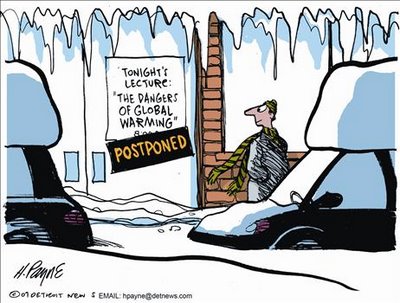
© H Payne
Climategate is shaping up to be the biggest science scandal in a generation. Given that the theory of Anthropogenic Global Warming (AGW) is being used to argue for radical changes in the economic and energy policies of every government on earth, affecting literally trillions of dollars of tax and economic policy, the stakes literally could not be higher. And the scientists involved in the scandal are the world's top climate scientists; the driving forces behind the UN's IPCC (Inter Governmental Panel on Climate change).
In mid-November, someone anonymously uploaded a ZIP file to the internet containing over a thousand e-mails and other data and program source code files totaling over 61MB lifted from the servers of the top British Climate Research Unit (CRU) at the University of East Anglia. It is not clear if the leak is the work of an outside hacker or the work of a whistle-blower from within.
While the leak was immediately a big story on the internet, most corporate-controlled media outlets initially attempted to downplay the controversy. For the first few weeks, the major TV outlets wouldn't even report the story. In fact, the BBC received the leaked documents first in October, but decided to sit on the story. The one outlet that did promote the story was FOX News, probably because the story fit their existing editorial slant and GOP talking points.
Most corporate print and on-line sources, such as
Time,
Huffington Post,
The Atlantic, and many others have attempted to downplay the controversy, attributing the seemingly damning quotes from the e-mails to "innuendo and smear campaigns" or saying that they were "taken out of context". White House spokesman Gibbs even characterized the flap as "silly".
Unfortunately for them, the archive of over 1000 e-mails provides ample context for the damning quotes and you don't need to be a scientist to recognize when people are discussing the fudging of results, destruction of data and underhanded manipulation of the peer-review process. Also unfortunately for them, the more you do know about the science, the more damning the revelations become. This controversy is not going away.
Comment: Subject: Climategate - Science Scandal of the Century
Date: Fri, 25 Dec 2009 22:14:51 +0100
From: Arkadiusz Jadczyk
To: editor@RockCreekFreePress.com
Dear Dr Sullivan,
In your article on Climategate you wrote:
"That's just not the way science works. No scientific theory is ever "settled". "
But you keep repeating:
"There is not even much dispute about the current direction of change; the climate does appear to be getting warmer."
This doesn't sound very scientific. "Getting warmer"? Taking into account which set of data? From what period? From where? How reliable are these data? How they are being processed? Which selection criteria are being used?
Using appropriate selection criteria you can prove any thesis. So, first of all selection criteria must be made explicit - then you can say:
"There is not even much dispute given these selection criteria" - which may be the case or may not be the case. The point is that because YOU do not know of any disputes, that does not necessarily mean that there are no disputes whatsoever. Are you sure you know the opinions of all experts all over the world during the last, say, 50 years? I would rather doubt it.
Moreover, even if there is really no dispute given your selection criteria, there may be a dispute concerning the chosen criteria, which may lead to the dispute of the final conclusion - if there CAN BE a final conclusion.
What I want to highlight is the fact that there are a number of experts who have been warning of the far more disastrous event of a coming ice age for some time now and, looking out the window and checking the thermometer seems to support that view rather better than the "global warming" idea. See, for example, this article from Time magazine back in 1974,
Another Ice Age?and then David Deming's article here:
The Coming Ice Age Consider also the experts here:
IceAgeNow and here:
IceCap Kind regards,
Arkadiusz Jadczyk
http://arkadiusz-jadczyk.org/
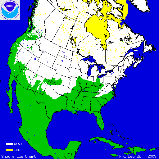
© National Ice Center (NIC)More than half the US is covered in snow
The National Ice Center (NIC), a tri-agency operational center, operated by the National Oceanic and Atmospheric Administration (NOAA), the United States Navy, and the United States Coast Guard, prepares a daily Northern Hemisphere Snow and Ice chart. This chart, prepared on a polar stereographic projection is centered on the North Pole with a 60 degree latitude of true scale, provides information on the areal coverage of the snow and ice. The visible and Near-infrared imagery of the polar orbiting satellites (POES) and geostationary orbiting environmental satellites (GOES) are the primary tools for the analysis of this snow and ice cover. Low resolution visible data are augmented whenever possible by the visible high resolution imagery and visible GOES, GMS, MTSAT, and METEOSAT data. In addition, ground weather observations, synthetic aperture radar (SAR), microwave scatterometer returns, numerical weather prediction, sea ice models, buoys, reconnaissance flights, and various DMSP visible and microwave products are incorporated into the daily Snow and Ice chart.




Comment: Subject: Climategate - Science Scandal of the Century
Date: Fri, 25 Dec 2009 22:14:51 +0100
From: Arkadiusz Jadczyk
To: editor@RockCreekFreePress.com
Dear Dr Sullivan,
In your article on Climategate you wrote: But you keep repeating: This doesn't sound very scientific. "Getting warmer"? Taking into account which set of data? From what period? From where? How reliable are these data? How they are being processed? Which selection criteria are being used?
Using appropriate selection criteria you can prove any thesis. So, first of all selection criteria must be made explicit - then you can say:
"There is not even much dispute given these selection criteria" - which may be the case or may not be the case. The point is that because YOU do not know of any disputes, that does not necessarily mean that there are no disputes whatsoever. Are you sure you know the opinions of all experts all over the world during the last, say, 50 years? I would rather doubt it.
Moreover, even if there is really no dispute given your selection criteria, there may be a dispute concerning the chosen criteria, which may lead to the dispute of the final conclusion - if there CAN BE a final conclusion.
What I want to highlight is the fact that there are a number of experts who have been warning of the far more disastrous event of a coming ice age for some time now and, looking out the window and checking the thermometer seems to support that view rather better than the "global warming" idea. See, for example, this article from Time magazine back in 1974, Another Ice Age?
and then David Deming's article here: The Coming Ice Age Consider also the experts here: IceAgeNow and here: IceCap
Kind regards,
Arkadiusz Jadczyk
http://arkadiusz-jadczyk.org/