Earth ChangesS


Fish

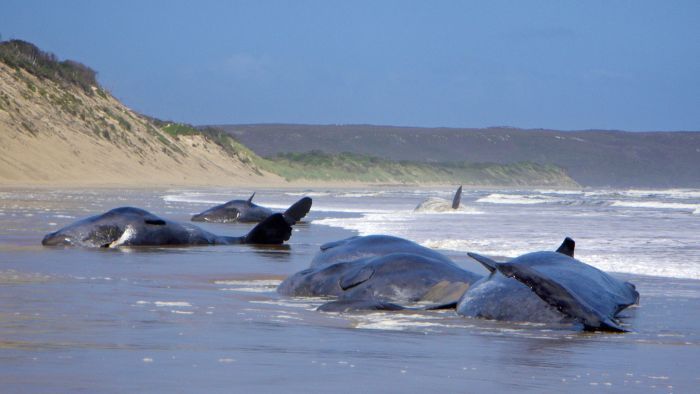
22 Sperm Whales Die in Australia

Image
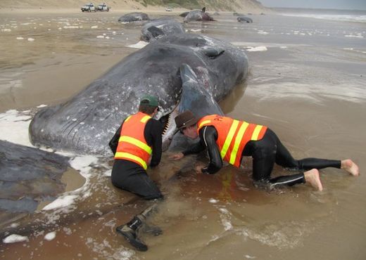
© Tasmania Parks And WildlifeSteve Mansfield (L) and James Grey from the Parks and Wildlife Service tag deceased sperm whales on Ocean Beach near Strahan on Tasmania's west coast on November 1. Wildlife staff are battling wet and windy conditions as they try to save four sperm whales stranded in shallow water after 22 others die.
Rescuers were racing against the clock Monday to save two huge sperm whales stranded on a Tasmanian sandbank after 22 others died, the Parks and Wildlife Service said.

Marine mammal specialists were on site in Macquarie Harbour at Strahan on Tasmania's northwest coast, but the rescue bid was hampered by rough weather.

Twenty-two of the whales -- each weighing two tonnes and up to 12 metres (40 feet) long -- washed ashore on Saturday at Ocean Beach near Strahan, and all of them died.

Four others came into the harbour and became stranded on a sandbank. Two of these were successfully refloated and swam back out to sea, but the other two remain stuck.

Rescuers said two minke whales also got into trouble nearby and died.

Tasmanian Parks and Wildlife incident controller Chris Arthur said the sperm whales were so big that they could not simply be pulled into deeper water by volunteers, instead requiring a more complicated rescue operation.
Bizarro Earth

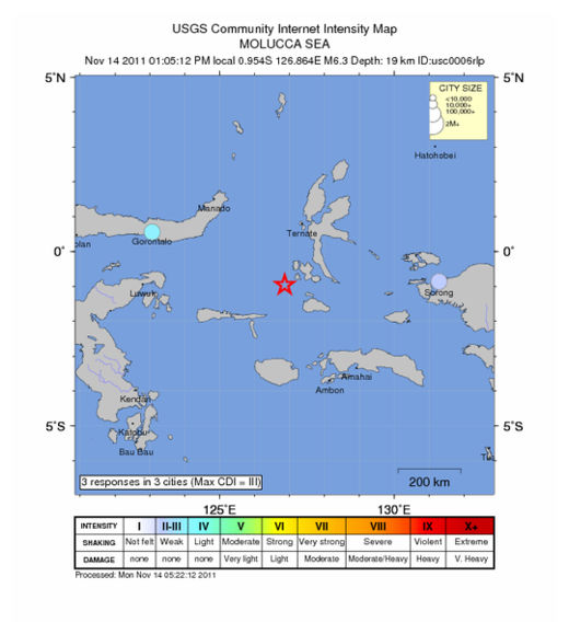
Molucca Sea - Earthquake Magnitude 6.3

Molucca Quake_141111
© USGSEarthquake Location
Date-Time
Monday, November 14, 2011 at 04:05:12 UTC

Monday, November 14, 2011 at 01:05:12 PM at epicenter

Time of Earthquake in other Time Zones

Location
0.954°S, 126.864°E

Depth
19.4 km (12.1 miles)

Region
MOLUCCA SEA

Distances
200 km (124 miles) SSW of Ternate, Moluccas, Indonesia

337 km (209 miles) NNW of Ambon, Moluccas, Indonesia

853 km (530 miles) N of DILI, Timor-Leste

1347 km (836 miles) NNW of DARWIN, Northern Territory, Australia

Igloo

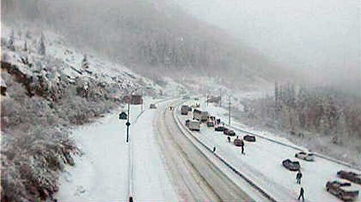
Canada: British Columbia storm cuts power, jams highways, stops ferries

Image
© CBC News
Stormy weather has forced BC Ferries to delay ferries on several routes on Friday afternoon, cut power to thousands and caused havoc on the Coquihalla and other B.C. highways.

Shortly after 2 p.m. BC Ferries began announcing ferries would not be sailing between Vancouver and Vancouver Island, and on several smaller routes until high winds subsided.

About 50,000 BC Hydro customers in the Lower Mainland, the Sunshine Coast and Vancouver Island regions were without power as the wind knocked trees onto power lines during the height of the storm around 3 p.m.

Then by 3:30 p.m. the wind had subsided in some areas and some of the ferries had resumed sailing, including those on the Tsawwassen to Swartz Bay route, but sailings on many routes were running behind schedule.

Bizarro Earth

US: Wanna experience the apocalypse before it happens? Visit Oklahoma!

Image
© Unknown
After one of the strangest local weather days in memory, an Oklahoma woman with a sense of humor asked on Twitter earlier this week:

"Wanna experience the apocalypse before it happens? Visit Oklahoma!"

She posted that on Monday night shortly after a 4.7-magnitude aftershock earthquake shook the state. The temblor occurred not long after six tornadoes ripped through southwest Oklahoma, which was preceded by flash-flooding in an area that's been plagued by a historic drought.

"Seriously, WHAT'S GOING ON?" someone else tweeted that night.

The answers vary. Global warning? Coincidence? Bad luck? Bad timing? End of time?

There's agreement on only one thing: It's been weird all year.

"Even for Oklahoma, this is crazy," said Rick Smith, a National Weather Service meteorologist in Norman. "Since January, we've been setting records. People are just kind of amazed and shocked."

State records set this year have ranged from the lowest temperature (31 degrees below zero in Nowata in northeast Oklahoma) to snowfall in a 24-hour period (27 inches, also in Nowata) to the largest hail stone (a spiky, six-inch piece recovered in Gotebo, in southwest Oklahoma).

This year also produced the state's highest-ever-recorded surface wind speed (151 miles per hour near El Reno, outside of Oklahoma City) and biggest known earthquake (5.6 magnitude, breaking the 1956 record).

Nuke

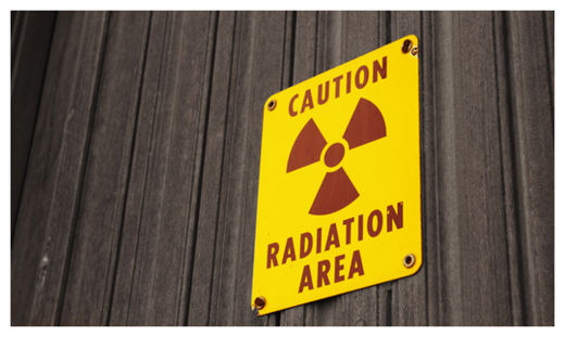
Traces of Mystery Radiation Detected Across Europe

Radiation Sign
© Life's Little Mysteries

Trace amounts of the radioactive material iodine-131 have been detected across Europe over the past two weeks, according to nuclear officials there. The source of this radiation-spewing material is unknown.

Iodine-131 is a by-product of the type of nuclear fission reactions that occur in reactors and nuclear weapons; it emits radiation that can cause cancer when absorbed in high enough doses. The International Atomic Energy Agency (IAEA) said the levels of iodine-131 that have been detected in several locations across Europe are abnormally high, but not high enough to pose a public health risk, Reuters reported today (Nov. 11).

Austria's Environment Ministry said the small levels of radioactive iodine it detected would expose the population to a radiation dose equal to just one-40,000th of the dose received in a transatlantic flight.

Bizarro Earth

Australia: Whales Stranded on Tasmanian Beach

Stranded Whales
© Audience Submitted22 sperm whales are stranded on Ocean Beach on Tasmania's west coast.

There has been a mass stranding of 20 sperm whales on Tasmania's west coast, with only four whales stuck in shallow water believed to still be alive.

The pod was discovered on Ocean Beach near Strahan early Saturday morning, but authorities say conditions in the water are too dangerous for rescuers to intervene.

Nearby, rescuers were making progress in freeing another eight sperm whales stranded on a sand bar in Macquarie Harbour, about four kilometres south of the beach.

Chris Arthur from the Parks and Wildlife Service says four of them were swimming freely, with a fifth joining them later in the afternoon.

Authorities are urging people to stay clear of the channel between Hells Gate and Table Head.

Arrow Up

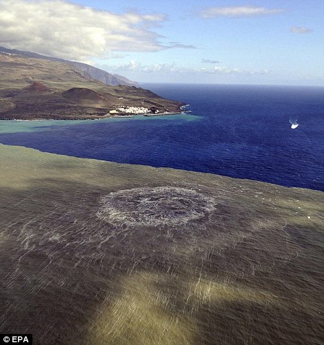
El Hierro Underwater Volcano's Eruption in Photos

Image
A brand new Canary island is emerging from the sea as an underwater volcano bubbles to the surface.

Magma off the Canary Island of El Hierro has been spewing 20 metres high as the sea boils with a smell of sulphur.

As it grows and gets closer to the surface, more and more debris such as stones start to shoot out of the volcano which, until now, has only shown its explosive power below the surface.

It is now just 70 metres from the surface and islanders are already trying to come up with a name for the new island. It is quite close to El Hierro and if it continues to erupt it could eventually meet up with the mainland.

Megaphone

Canada 'could expect' massive earthquake at any time: geophysicist

Earthquake Bowman, Que
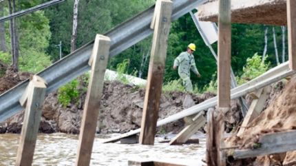
© Adrian Wyld / The Canadian PressA Hydro Quebec worker navigates a causeway where a section of road collapsed following an earthquake in Bowman, Que., Wednesday, June 23, 2010. (Adrian Wyld / THE CANADIAN PRESS)
Canada could expect a major earthquake at any time and a top geophysicist says it should prepare itself if it is to avoid the kind of disasters that befell Japan, Italy and China in recent years.

John Cassidy, head of earthquake seismology at the Geological Survey of Canada, says large earthquakes have hit parts of Canada numerous times - and will again.

"Certainly we could expect an earthquake at any time and should be prepared for a large earthquake at any time in Canada," Cassidy said in an interview prior to delivering a lecture at Carleton University.

"We've seen many over the years, going back in time."

He says the most vulnerable region is the West Coast, which has been hit with giant, magnitude-9.0 quakes 13 times in the last 6,000 years, the last of them 311 years ago.

Bizarro Earth

US: Earthquake Magnitude 4.2 Western Montana

Image
© USGS
Date-Time:
Friday, November 11, 2011 at 17:51:53 UTC

Friday, November 11, 2011 at 10:51:53 AM at epicenter

Time of Earthquake in other Time Zones

Location:
46.618°N, 113.557°W

Depth:
12.1 km (7.5 miles)

Region:
WESTERN MONTANA

Distances:
21 km (13 miles) SE (145°) from Clinton, MT

32 km (20 miles) W (260°) from Drummond, MT

37 km (23 miles) NNW (328°) from Philipsburg, MT

314 km (195 miles) ESE (111°) from Spokane, WA

666 km (414 miles) N (349°) from Salt Lake City, UT

Bizarro Earth

New Caledonia: Earthquake Magnitude 5.2 Offshore

Image
© USGS
Date-Time:
Friday, November 11, 2011 at 19:00:47 UTC

Saturday, November 12, 2011 at 06:00:47 AM at epicenter

Time of Earthquake in other Time Zones

Location:
22.750°S, 168.268°E

Depth:
130.7 km (81.2 miles)

Region:
NEW CALEDONIA

Distances:
138 km (85 miles) SSE of Tadine, Loyalty Islands, New Caledonia

194 km (120 miles) ESE of NOUMEA, New Caledonia

369 km (229 miles) SSW of Isangel, Tanna, Vanuatu

1624 km (1009 miles) ENE of BRISBANE, Queensland, Australia