Earth ChangesS


Bizarro Earth

Indonesia's Mount Lokon volcano shaken by double eruptions

Image
Mount Lokon in Tomohon, North Sulawesi, erupted twice throughout Thursday (31/01/2013) afternoon. Head Volcano Observation Post Lokon and Mahawu, Center for Volcanology and Geological Hazard Mitigation (PVMBG) Bandung Geological Agency, Ruskanda Farid Bina, said the first explosion occurred at 6:54 pm and was followed by a second explosion at 10:44 pm, and that was followed by a boom that sounded up to the settlements located around the crater.

"We could not observe the height of the eruption of dust because of the condition of the fog around the crater. At first eruption eruption dust altitude of about eight hundred yards," said Farid. He said the series of eruptions occurred after an increase in seismicity that occurred on Wednesday (30/1) at 22:54 pm. "Until now the status is still at alert level three," he said. - Inilah translated

Bizarro Earth

Russian scientists voice concerns about dangers of a supervolcano erupting in Italy

Image
It looks like we may be in for an earth-shattering explosion. A dormant super volcano appears to be stirring under the Phlegraen Fields of Naples in Italy. Rising soil temperatures and surface deformation in the area have alarmed seismologists. In the distant past, volcanic super eruptions caused global climate change responsible for mass extinctions of plant and animal species. So far, scientists are unable to model the potential consequences of an awakening supervolcano. Latest studies show that the Phlegraen Fields have actually been swelling above sea level at a rate of 3 cm per month. Micro quakes and large amounts of gases accumulated in soil indicate that the volcano may be preparing to erupt, says Vladimir Kiryanov, Assistant Professor of Geology at the St. Petersburg University.

"The Phlegraen Fields is a supervolcano. Yellowstone in the United States and Toba in Indonesia are also supervolcanoes capable of spewing more than 1,000 cubic km of magma. These are catastrophic eruptions. There was a huge volcanic eruption in the Phlegraen Fields some 30,000-40,000 years ago. Volcanic ash from that eruption is still found in the Mediterranean, Bulgaria, Ukraine, and even in Russia. We are now seeing the expansion of a magma pocket, which means that there might be an eruption at a certain time."

Bizarro Earth

USGS: Earthquake Magnitude 6.0 - 101km W of Craig, Alaska

Image
© USGS
Event Time:
2013-01-31 09:53:43 UTC
2013-01-31 00:53:43 UTC-09:00 at epicenter

Location:
55.584°N 134.745°W depth=9.7km (6.0mi)

Nearby Cities:
101km (63mi) W of Craig, Alaska
303km (188mi) S of Juneau, Alaska
316km (196mi) WNW of Prince Rupert, Canada
409km (254mi) WNW of Terrace, Canada
571km (355mi) S of Whitehorse, Canada

Ice Cube

Wikipedia climate fiddler William Connolley part of IPCC "short list" team?

Image
Apparently Mr. Connolley has edited 5428 Wikipedia articles, most about climate. Die Kalte Sonne:
Unbelievable but true: The Wikipedia umpire on Climate Change was a member of the UK Green Party and openly sympathized with the views of the controversial IPCC. So it was not a referee, but the 12th Man of the IPCC team.
I'm not sure how accurate the translation is, but it suggests he was somehow part of the IPCC "short list" team. See it here at Die Kalte Sonne via this Google Translate link.

With over 5000 articles he's edited, it makes you wonder if Mr. Connolley was employed by someone or some organization specifically for the task.

Comment: A 2009 report revealed that a British scientist and Wikipedia administrator rewrote climate history, editing more than 5,000 unique articles in the online encyclopedia to cover traces of a medieval warming period - something Climategate scientists saw as a major roadblock in the effort to spread the global warming message. Connolley, one man in the nine-member team who is a U.K. scientist, a software engineer and Green Party activist, took control of Wikipedia's entries to see that any trace of the true climate history would be erased.
Wikipedia History of climate gets 'erased' online


Bizarro Earth

Earthquake Magnitude 6.2 - ENE of Lata, Solomon Islands

Solomon Quake_300113
© USGS
Event Time
2013-01-30 23:03:45 UTC
2013-01-31 10:03:45 UTC+11:00 at epicenter

Location

10.518°S 166.486°E depth=10.0km (6.2mi)

Nearby Cities
74km (46mi) ENE of Lata, Solomon Islands
559km (347mi) N of Luganville, Vanuatu
726km (451mi) E of Honiara, Solomon Islands
822km (511mi) NNW of Port-Vila, Vanuatu
1153km (716mi) N of We, New Caledonia

Windsock

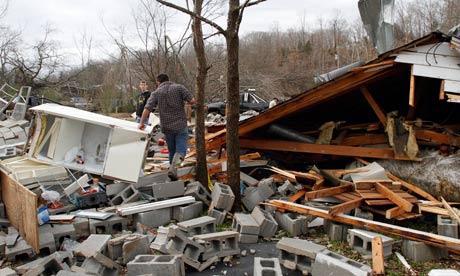
Tornadoes tear through four states in the U.S., killing at least two

Image
© Photograph: Butch Dill/APResidents search through debris after a suspected tornado ripped Coble, Tennessee, destroying several homes and businesses.
Tornadoes were reported in Mississippi, Georgia, Indiana and Tennessee, an unusual development in January

Tornadoes ripped through four states on Tuesday night and Wednesday, killing at least two people, as an Arctic cold front clashed with warm air to produce severe weather over a wide swath of the nation.

Tornadoes were reported in Mississippi, Georgia, Indiana and Tennessee, an unusual development in January when the focus is more likely to be on snow and ice.

The National Weather Service said twisters touched down in Sardis, Mississippi, and heavily damaged homes in Solsberry, Indiana, wiping out power in the surrounding areas. Three twisters were confirmed in Tennessee and a possible tornado hit southeastern Arkansas.

In Georgia, a man was killed when a tornado hit his mobile home late Wednesday morning, said Bartow County administrator Pete Olson.

In north Nashville, a man died when a tree fell on his garage apartment, according to Jeremy Heidt, spokesman for the Tennessee Emergency Management Agency.

Bizarro Earth

USGS: Earthquake Magnitude 6.8 - 43km N of Vallenar, Chile

Image
© USGS
Event Time:
2013-01-30 20:15:43 UTC
2013-01-30 17:15:43 UTC-03:00 at epicenter

Location:
28.181°S 70.800°W depth=45.7km (28.4mi)

Nearby Cities:
43km (27mi) N of Vallenar, Chile
101km (63mi) SSW of Copiapo, Chile
196km (122mi) NNE of La Serena, Chile
203km (126mi) NNE of Coquimbo, Chile
585km (364mi) N of Santiago, Chile

Bizarro Earth

USGS: Earthquake Magnitude 5.3 - 263km WNW of Bandon, Oregon

Image
© USGS
Event Time
2013-01-30 03:14:28 UTC
2013-01-29 18:14:28 UTC-09:00 at epicenter

Location:
43.566°N 127.598°W depth=10.2km (6.4mi)

Nearby Cities:
263km (163mi) WNW of Bandon, Oregon
274km (170mi) W of Coos Bay, Oregon
347km (216mi) W of Roseburg, Oregon
364km (226mi) WSW of Corvallis, Oregon
395km (245mi) WSW of Salem, Oregon

Cloud Lightning

1 dead as powerful winds, rain batter the U.S. South

Powerful winds, rain and hail battered parts of the South on Wednesday, killing at least one person as the large storm system damaged homes, overturned cars on an interstate and knocked out electricity to thousands.At least one tornado was confirmed and several more suspected, and conditions remained ripe for more. Since Tuesday, the system had caused damage across a swath from Missouri to Georgia.

In recent days, people in the South and Midwest had enjoyed unseasonably balmy temperatures in the 60s and 70s. A system pulling warm weather from the Gulf of Mexico was colliding with a cold front moving in from the west, creating volatility.

Police said high winds toppled a tree onto a shed in Nashville, Tenn., where a man had taken shelter, killing him. As the storm crept eastward, officials reported a possible tornado in Adairsville, Ga., about 60 miles northwest of Atlanta. At least 10 cars were overturned on Interstate 75, and emergency crews were trying to get to people reported trapped in homes and buildings, said Bartow County Fire Chief Crag Millsap.

Across the region, downed power lines, trees and tree limbs were making it difficult to reach people who needed help.

Bizarro Earth

Eruption of Japan's Mt. Fuji volcano could force the evacuation of more than half a million

An eruption of Mount Fuji could force some 567,000 people to evacuate their homes, according to a new estimate. The projection is part of an evacuation plan crafted by the Shizuoka Prefectural Government that also says more than 130,000 people, comprising some 50,000 households, would have to relocate if lava were to reach residential districts in the city of Fuji, which lies just south of the 3,776-meter mountain. Depending on the number and locations of vents, evacuation from wider areas could be needed. The plan is based on a hazard map prepared by the central government based on Fuji's last eruption, in 1707. Under the evacuation plan, 10 zones have been designated at the foot of the mountain based on the expected direction of lava flows. The plan specifies evacuation zones in four grades.
Image
The Yamanashi Prefectural Government is preparing a similar evacuation plan. Plans will be finalized at a consultation forum involving Shizuoka, Yamanashi and Kanagawa prefectures and the central government. Joint evacuation drills in the three prefectures will also be conducted. - Japan Times