Earth Changes
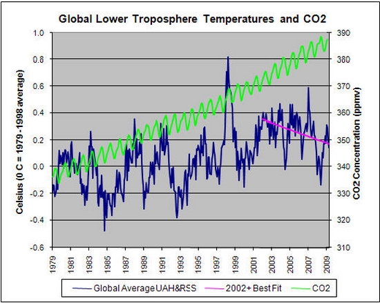
Well, the answer is simple - because 2007 turned out to be the coolest year recorded for the last 30 years. This, the public was not told.
The public was also not told that, since the warm year of 1998, there has been continuous cooling. What the public is told is that, during the twentieth century, there was a global temperature increase of 0,6 oC.
This is true, but what is left out is that most of the warming took place from 1920 to 1940 and that global temperature fell from 1940 to 1970, prompting announcements in the mid 1970s that a global ice age was about to pounce on us.
![]() |
©AP |
A wild black bear whose head got stuck inside a 2-gallon clear plastic jug |
The wild black bear is thought to have been foraging for food when its head became stuck inside a 2.5 gallon (9.5 litre) clear plastic jar that usually holds sweets or popcorn.
The two-year-old animal could breathe but could not eat or drink and was probably suffering from dehydration and hunger.
A linear string of mud pots and mud volcanoes suggest surface evidence for a southern extension of the San Andreas Fault that runs through the Salton Sea, according to a paper published in the August issue of the Bulletin of the Seismological Society of America (BSSA).
Researchers David K. Lynch and Kenneth W. Hudnut of USGS report the results of a comprehensive survey of mud pots in the area immediately east of the southeastern-most portion of the Salton Sea in Imperial County, Calif. Using satellite imagery, followed by a physical examination of the land, they identified a cluster of 33 mud pots, mud volcanoes and sink holes which, when plotted, form a clear linear pattern.
Mud pots and mud volcanoes are geothermal features produced when water or gas is forced upward through soil and sediments. Mud pots can assume a variety of forms, typically being depressions or enclosed basins containing gas seeps, bubbling water or viscous mud. Mud pots can also be water-laden and appear as bubbling muddy water. Mud volcanoes, on the other hand, are elevated conical structures composed of accumulations of viscous mud extruded from a central vent. They range from finger-sized to several kilometers across, though the largest in the Salton Sea area are about 2 meters high. Small mud volcanoes on land, ranging from one to 10 feet in height, are usually called mud cones or gryphons and are usually associated with volcanic and seismic activity.
Another Collapse: Rock slide narrowly misses bus on British Columbia highway as cliff face collapses
![]() |
©The Canadian Press / Jonathan Hayward |
A massive rock slide blocks the Sea-to-Sky highway near Porteau Cove, B.C. after a cliff face collapsed onto the highway. |
Peter Skeels's bus was lumbering up the highway that winds through British Columbia's breathtaking coastal mountains when he heard a roar that sounded like violent hail.
He drove through and it wasn't until a few minutes later, when Skeels pulled over and saw the bus covered in dents and its windows shattered, that he realized the hailstorm was really a massive pile of rocks and boulders raining down on the road.
"There was suddenly an unbelievable noise, it sounded like a hailstorm - you didn't really know what to make of it," said Skeels, who lives in Whistler and regularly drives the highway between Vancouver and the mountain resort community that will jointly play host to the 2010 Winter Olympics.
Meteorologist Vince DiCarlo spent early Tuesday surveying the damage that happened around 6 p.m. Monday along Goodnight Road and Highway 29 in the China Grove area.
The quake shook downtown L.A. buildings and was felt as far south as San Diego and as far east as Palm Desert.
Scientists say the break, the largest on record since 2005, is the latest indication that climate change is forcing the drastic reshaping of the Arctic coastline, where 9,000 square kilometres of ice have been whittled down to less than 1,000 over the past century, and are only showing signs of decreasing further.
Off the eastern edge of Andros Island lies the Tongue of the Ocean, a hundred-mile, inky blue swathe of sea over the Great Bahama Canyon. Bounded on the south and east by the shallow sands of the Bahamas banks, the seafloor drops precipitously from 3 meters near shore to more than 2,000 meters farther out.
While the region boasts a colorful history of pirates and shipwrecks, scientists will head there this summer seeking treasure of a different sort: beaked whales, some of the deepest diving and least known animals on Earth. The research aims to solve one of the most contentious mysteries in marine biology today - the relationship between military sonar and stranded, dying whales.