Secret HistoryS

Flashlight

Archaeologists discover 1000 year old 'lost' village of Cadzow in Scotland

medieval village Cadzow
© Transport ScotlandArtists impression of the lost village of Cadzow
Construction work to upgrade Central Scotland's motorway network on the M74 near Hamilton has unearthed a rare archaeological discovery, including remnants of a medieval village and a collection of mediaeval coins believed to date from the 10th or 11th Century.

The discovery was made on the verge of the M74 motorway near Junction 6 Hamilton, opposite Hamilton Services, where the carriageway is being widened as part of the ยฃ500m M8 M73 M74 Motorway Improvements Project.

Keith Brown, Minister for Infrastructure, Investments and Cities, visited the site and viewed the rare collection of coins and artefacts, which archaeologist believe to be more than 1000 years old and could finally identify the location of the lost village of Cadzow.

Black Magic

Report claims Hitler engaged in bizarre sexual fetish acts and forced his niece to act them out

hitler nazi salute
© AFP/Getty Images
The latest personal information to be revealed about Adolf Hitler since the "micro-penis" report shows that the Nazi leader had some seriously strange sexual interests.

A U.S. intelligence report claims the Fuhrer indulged in bizarre sexual fetishes and even made his own niece act them out. A psychological profile compiled by American spies revealed that Hitler was a coprophiliac โ€” someone who gets sexual pleasure from feces.

He allegedly forced his niece, Geli Raubal, to perform disturbing sex acts.

Before this finding was made public, the most recent information revealed about Hitler's sex life was that he had an abnormally small, deformed penis and had only one testicle.

Info

Ruling over one of the greatest empires in the ancient world - the Persian Pishdadian Dynasty

Iran, Gate of all nations.
© Photo source: CC BY-SA 3.0Iran, Gate of all nations.
It is arguable that the most famous empire based in Persia was that of the Achaemenids. This was one of the greatest empires in the ancient world, and is best known in the Western world for its wars with the Greeks during the 5th century BC and the Macedonians later. According to Persian epic tradition, there were other dynasties that preceded the Achaemenids. The archaeological record shows that prior to the rise of the Achaemenids, Persia was under the rule of the Elamites, and, later, in certain areas, under Assyrian and Median control. The Avesta (a collection of Zoroastrian sacred texts) and the Shahnameh (the national epic of Iran) however, state that this period saw native Persian rule in the form of the Pishdadian and Kayanian Dynasties.

Early Rule of Persia

The Pishdadian Dynasty is said to have produced the first kings who ruled over the land of Persia. Some of the Pishdadian kings are claimed to have even ruled for thousands of years. On the one hand, it has been suggested that given these impossibly long reigns, the historical veracity of these kings are somewhat dubious. On the other hand, it has been argued that such tales should just not be taken too literally. Instead, the reign of each king ought to be regarded as being "a sequential record of human development", as "developments that correspond to archaeological / historical ages such as the Stone and Metal Ages" are said to have happened during their rule.

The first mortal, who was also the first Pishdadian king, for instance, is recorded to have been Kaiumers (spelled also as Kayomars and Keyumars). This name evolved from Gayomard, and Gaya Maretan (literally translated as 'life mortal') before it. Ferdowsi, in the Shahnameh, describes Kaiumers as such...

Info

Is this a huge million-year-old complex of underground man-made structures?

Underground complex
Most archaeologists and historians agree that human civilization only emerged some 10,000 to 12,000 years ago. Yet many researchers have drawn attention to artifacts and various other evidence of advanced civilizations long before this, even millions of years earlier.

Among them is Dr. Alexander Koltypin, a geologist and director of the Natural Science Research Center at Moscow's International Independent University of Ecology and Politology.

Koltypin has analyzed ancient underground structures across the Mediterranean and identified similarities that lead him to believe the sites were once connected. Furthermore, the weathering of the structures, their material composition, and the geological features and historic changes in the region, lead him to believe they were built by an advanced civilization hundreds of thousands or millions of years ago.

Archaeologists working in the region usually date the sites by looking at the settlements located on them or nearby. But these settlements were simply built upon existing prehistoric structures, Koltypin said.
"When we examined the constructions ... none of us never for a moment had a doubt that they are much older than the ruins of the Canaanite, Philistine, Hebraic, Roman, Byzantine, and other cities and settlements that are placed on it and around," he wrote on his website.
He climbed a hill about 1,300 feet high near the Hurvat Burgin ruins in Adullam Grove Nature Reserve, central Israel. As he looked over the site, he recalled a similar feeling from when he had climbed to the top of the rock city Cavusin in Turkey.

Bomb

The MOVE bombing - An urban tragedy

MOVE bombing
© nhdmove.weebly.comOn May 13, 1985, the City of Philadelphia dropped a bomb on a house, 6221 Osage Avenue in West Philadelphia, that had been occupied by members of the MOVE, a radical social group that sought to return human society back to its natural roots.
On May 13, 1985, one of the most shameful, horrific attacks by US police ever took place in West Philadelphia. Eleven people - including five children - were killed in a deliberate massacre. A racist and political attack on a radical community group known as the MOVE Organization, city and police officials were revealed to have intentionally set their home ablaze, let the fire rage, and violently kept escaping men, women and children trapped inside.

Featuring a harrowing first-hand account with the only adult survivor of the atrocity, Ramona Africa, Abby Martin documents an indispensable - but largely unheard of - moment in US history. From MOVE's formation, to the arrest of the MOVE 9 political prisoners, to the build-up to the infamous bombing, The Empire Files chronicles an act that cannot be forgotten.

X

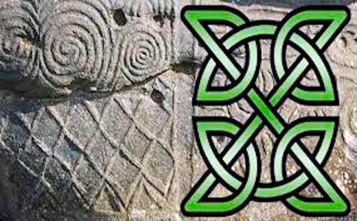
Decoding ancient Celtic astronomical symbols, links to Jungian archetypes

celtic symbols, green x
© www.ancient-origins.net"ancient X files"
My nonprofit educational corporation, The Celtic Collection Program, exhibits the largest privately owned collection of Celtic artifacts in the United States. When we started purchasing the artifacts from private collections and ancient galleries several years ago, I observed a motif of X and interconnected X designs on some of them, including important ones likely used to perform ceremonies. As a historian and a therapist with preferences for Psychoanalytic Theory and Neo-Freudian traditions such as Analytical Psychology, a school of psychology that originated from the ideas of Swiss psychiatrist Carl Jung, interpreting these symbols became a personal and professional challenge.

After fifteen years of identifying hundreds of linear and X patterns on artifacts and studying the symbolism of Stonehenge and Newgrange, I have discovered remarkable data, some of which has led me to consider that there may be a correlation between ancient X symbolism and what Dr. Carl Jung referred to as the "Collective Unconscious", a subconscious storehouse of buried memories inherited from our ancestral past.

Importance of the Sun in Ancient Celtic Society

According to Dr. Miranda J. Green in her book, Dictionary of Celtic Myth and Legend, the sun was significantly meaningful to the ancient Celts. She states that "One of the most important venerated natural phenomena was the sun, seen as a life giver, promoter of fertility and healing" and that "coins were struck with sun symbols associated with the horse".
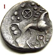
coin w x
© Lewis HalesCoin from Iceni Tribe 62 AD
Some of the primary symbols for the Sun in ancient Celtic times were an X or a four-spoked wheel featured on bronze axes, swords, coins, urns, pottery and jewelry since Neolithic Europe. "Hallstatt Iron Age sheet-bronze vessels were decorated with repousse crosses and solar wheels," states Dr. Green.

The X symbol was no doubt a significant astronomical representation for thousands of years; perhaps one of the most powerful ideograms valued by the Celts, which explains the X motif on our artifacts. The X artifacts range from 62 AD to 400 BC. However, to uncover the mystery of the interconnected design, a close evaluation of the symbols at Stonehenge and Newgrange needed to be conducted.

Bacon

Study reveals surprising facts about Medieval children's diet in England

Medieval children's milk teeth
© University of KentMedieval children's milk teeth.

Studying foods people ate is an important step towards learning more about ancient cultures. Historians try to piece together what foods ancient people ate, preparation methods, and the foods people avoided to try to gain insight into ancient cultures as a whole. This information can help to provide a more comprehensive view of how ancient cultures lived, and how they evolved into modern times. Foods can be studied by viewing ancient texts, the discovery of bones and eating utensils from ancient meals, and studying teeth from ancient individuals.

A recent study conducted on the teeth from children living during the 11th through 16th centuries provides insight into the foods those children ate, and the impact that socio-economic status may have had on their diet. According to Daily Mail, the teeth were studied through the use of 3D microscopic imaging. The testing, known as dental microwear texture analysis, measures microscopic changes in the surface of teeth. By using this testing, scientists were able to study the enamel from children's molars without damaging the teeth.

Info

New tower and underground structures discovered at Angkor Wat

The Angkor Wat temple
© Tang Chhin Sothy/AFPThe Angkor Wat temple is Cambodia's most popular tourist destination.
Phnom Pen - Angkor Wat, the immense temple complex in Cambodia, might be larger and more extensive than previously thought, with new structures discovered below the ground.

Researchers used LIDAR or ground-penetrating radar and airborne light detection and ranging techniques to detect several structures that are yet to be excavated. An immense structure to the south of the complex measures 1500 by 600 meters, and researchers are still unclear as to its purpose.

One of team's lead researchers, University of Sydney's Professor Roland Fletcher, said the massive size of this structure was intriguing.

Additionally, the team also found several towers that were pulled down as the main temple was being built. While more evidence is required before the team can make conclusions about why this happened, initial hypotheses revolve around the fact that these were subsidiary shrines, used during the construction of the main temples. The number of these towers and the existence of the southern structure seem to indicate that Angkor Wat might be larger than previously thought, and much more intricate.

A separate research team also uncovered a large bronze workshop adjacent to the ancient Royal Palace of Angkor. Archaeologists have been searching for decades, for the site where Angkor's bronze statues, some as large as six meters, were cast.

Snowflake

The year without a summer: 1816

Tambora volcano
© Iwan Setiyawan/KOMPASThe Tambora volcano on the island of Sumbawa, Indonesia.
This year marks the 200th anniversary of "1816 -- the year without a summer."

Although two centuries have lapsed, mention the year 1816, and most people will immediately associate it with the "year without a summer." What happened that year and what caused it?

Climatologists agree that volcanoes can cause serious, but temporary, effects on world weather. It's become an accepted theory that the 1816 weather phenomenon was caused by the April 5, 1815, eruption of the Tambora volcano on the island of Sumbawa, Indonesia. The initial eruption was followed by a more intense phase of volcanic activity from April 10-12, with eruption activity continuing sporadically until mid-July.

As a result of the volcanic activity, an estimated 100 kilometers of dust ash were ejected into the atmosphere, causing complete darkness for three days on the island of Madura. An estimated 10,000 people were killed in the eruption, with an additional 82,000 who subsequently died from starvation and/or disease.

The Tambora eruption, guessed to have been 13 times more powerful than the May 18, 1980, Mount St. Helens eruption in Washington, blocked out the sun's warming radiation. Increased cyclone activity was also attributed to the Tambora eruption. The effects of the volcanic activity appeared to have been abnormally concentrated near Newfoundland, with activity throughout New England, and in Europe, from central Ireland across England to the Baltic Sea.

Info

Ancient Roman map puzzle gets new piece

Roman map puzzle
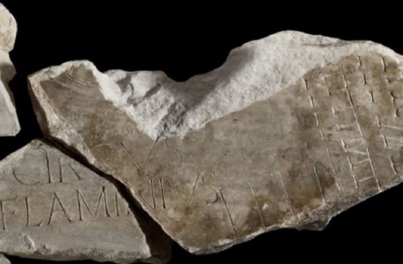
© Sovrintendenza Capitolina ai Beni CulturaliThis is the latest addition to an ancient Roman map puzzle.
A fragment of the world's oldest and largest unsolved jigsaw puzzle, a 2,200-year-old map of Rome made of thousands of marble fragments, has been finally reunited to the other existing pieces, according to the Rome Cultural Heritage Superintendency.

Connecting to a large piece discovered in 1562, the new fragment bears an inscription that completes the word Circus Flaminius.

The map, known as Forma Urbis Romae, was carved into marble slabs between 203 and 211 A.D., during the rule of the emperor Septimius Severus.

Only fragments remain today and most are held in the Capitoline museum. They cover just 10 percent the original map surface that once stood on a wall in the Templum Pacis (Temple of Peace).

The wall still survives today in a building near the 6th-century Church of Santi Cosma e Damiano. Rows of holes where the map was attached using bronze clamps can still be seen.