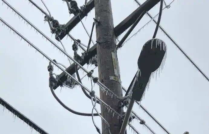
© Brad CarlIcicles hang from power lines and poles Tuesday in Oklahoma City.
"Tree carnage" has been
reported in Oklahoma City, where vegetation and power lines have been collapsing beneath the weight of the accreting rime. Up to another half-inch of freezing rain — rain that freezes on contact with the surface — is possible as more waves move through the affected regions into Wednesday.
The University of Oklahoma
warned students of "lightning-infested sleet and freezing rain storms" that would hit the central Oklahoma campus, with thunder echoing throughout Oklahoma City. Social media was replete with photos of toppled trees, the storm posing a particular danger to agriculture.
It was the first time that the National Weather Service in either Norman or Tulsa had issued an ice storm warning during the month of October, and the pre-Halloween glaze was the worst ice storm to strike at any time of year in at least five years.
At least an inch of ice
had already accreted on surfaces by early afternoon just west of Oklahoma City in the town of El Reno.
Oklahoma City Memorial and Oklahoma Forestry Services crews were scrambling to save the "Survivor Tree," an American elm at the Oklahoma City National Memorial. The monument
honors the 168 people who lost their lives at the Alfred P. Murrah Federal Building in a terrorist bombing on April 19, 1995.
"We lost a branch but have propped up others to save them,"
wrote the Oklahoma City National Memorial and Museum on Facebook. "We will continue to monitor it 24/7 throughout this historic storm."
One of the heaviest bands of freezing rain was working northeast along Interstate 44 in southwest Oklahoma midmorning Tuesday, riding along the heavily traveled H.E. Bailey Turnpike. The Oklahoma Department of Transportation reported "severe" travel hazards, stating: "Driving in these conditions can be dangerous. Please avoid driving if possible."
In Stephens County, just east of Lawton-Fort Sill, commercial vehicles
were restricted from Highway 81 between Marlow and Duncan because of power lines hanging low over the roadway. Numerous house fires
occurred Monday, many a result of downed wires.
Interstate 40 eastbound was
narrowed to one lane in Gore, near the Arkansas border, because of a crash.
Emergency management also reported trees blocking the eastbound lanes of Southwest 119th Street in Moore, a suburb just south of Oklahoma City.
Some residents took to social media to voice their experiences weathering the storm. One Twitter user
wrote that their father, age 55, fell and fractured a vertebrae while trimming a tree coated in ice in Oklahoma City.
"So many tree limbs popping, pulverizing our power lines,"
wrote another.
Numerous school and extracurricular program closings
were reported across the state, with some classes canceled entirely while others were moved online for virtual instruction.
"It's been years since [Oklahoma City] has had to deal with a significant winter weather event," wrote Brad Carl, a former Tulsa television meteorologist who now works for the Nature Conservancy in Oklahoma City. "I think this ice storm has painfully reminded us that winter can be wicked around these parts when it really wants to be."
Carl said he experienced flickering lights throughout the day Monday, finally losing power like tens of thousands of others in the city limits early Tuesday morning. He captured images of iced-over leaves and branches, and icicles hanging from power lines like stalactites.
The time of year, when trees are still fully-leafed and vegetation is somewhat verdant, means the ice event is even more disruptive, since there is greater surface area on trees where ice can accrete. That allows more weight to build up, making it easier for limbs and branches to collapse.The cause of the ice storm is a narrow layer of cold air at the surface below a mile in altitude. At 7,800 feet, it was nearly 47 degrees Tuesday morning over Oklahoma City, yet temperatures at ground level have remained below freezing since midmorning Monday. That permits liquidwater to fall and hit the ground, quickly freezing on contact.
In the warmer air at the mid-levels, periodic surges of moisture have brought repeated rounds of moderate precipitation, with some sleet mixing in at times. That's cut back on freezing rain totals in a few spots but made for more difficult travel.
Overnight temperatures will warm just above freezing, allowing the final bout of precipitation Wednesday — perhaps the heaviest — to fall as rain. A period of heavy snow is even possible with moisture wrapping around the low-pressure system late Wednesday into Thursday in West Texas and the Texas Panhandle.
Highs across central Oklahoma will rebound into the 60s by the weekend, leaving residents to clean up the mess in more comfortable conditions.
ELECTRICAL CURRENT GONE BERSERK! WOW!
R.C.