Several interesting things caught our eye in the tropics in the past week, including Hurricane Hector's length of time as major hurricane in the northeastern Pacific Ocean, Tropical Storm Debby's formation in the Atlantic Ocean, an active eastern half of the Pacific Ocean and Typhoon Shanshan's scrape with Japan.
Below, we'll go into greater detail about each of these notables.
Hurricane Hector Sets Record in Northeastern Pacific OceanHurricane Hector passed well south of the Big Island of Hawaii on Wednesday as a major hurricane, one classified as Category 3 or higher on the
Saffir-Simpson Hurricane Wind Scale.
Hector generated high surf and breezy conditions on the Big Island, with no more than a few outer rain showers scraping portions of that island.
As of Saturday morning, Hector was still maintaining Category 3 intensity about 1,000 miles west of Hawaii.
That means it had been a major hurricane for at least 7.5 consecutive days, the longest duration any hurricane in the northeastern Pacific Basin has held that intensity, according to Colorado State University tropical scientist
Dr. Phil Klotzbach.
The previous record was held by Hurricane Norbert, which was a major hurricane for 7 consecutive days in the northeastern Pacific in 1984.
Hector also generated the most Accumulated Cyclone Energy (ACE) of any northeastern Pacific hurricane
since Dora in 1999, Klotzbach noted. A hurricane's ACE value is calculated by adding up its wind speeds through its life cycle. Long-lived, intense hurricanes have a high ACE index while short-lived, weak tropical storms have a low value.
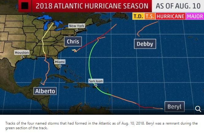
Debby Forms Ahead of Schedule in the AtlanticDebby formed in the northern Atlantic Ocean more than 1,000 miles west of the Azores on Tuesday, originating as a subtropical storm before transitioning to a tropical storm by early Wednesday.
This came slightly more than two weeks ahead of schedule, as the fourth named storm of the Atlantic hurricane season typically
forms on Aug. 23, according to the National Hurricane Center.
Debby didn't last long, dissipating late Thursday, but what's notable is that
it was the third subtropical storm of the 2018 season out of the four named storms so far.
© The Weather Channel (screen capture)
formed May 25, making landfall along the Florida Panhandle on Memorial Day.
Beryl became the first hurricane of the 2018 Atlantic season June 6 but quickly dissipated June 8 while tracking toward the northeastern Caribbean. Its remnants reformed into a subtropical storm in the central Atlantic Ocean June 14, though it never impacted land as a subtropical storm.
Hurricane Chris in early July was the only named storm so far this hurricane season to not be classified as subtropical during its existence.
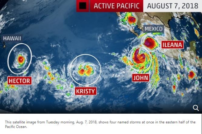
4 Storms in Eastern Half of Pacific at the Same TimeThe eastern half of the Pacific Ocean came to life in the past week, with the development of four named storms stretching from near Mexico's Pacific coast to several hundred miles east of Hawaii.
Hurricane Hector, the first to form, passed south of Hawaii on Wednesday.
Over 1,400 miles east of Hector was
Kristy, which had strengthened quickly into a tropical storm by Tuesday morning.
About 1,000 miles east of Kristy and closer to Mexico's Pacific coast early Tuesday were
Hurricane John and
Tropical Storm Ileana.
Ileana didn't stick around long, dissipating late Tuesday morning after John's nearby dominant and larger circulation caused it to fall apart. The remnants of Ileana then pivoted north and northwestward around John and became less defined.
You can see all four of these tropical cyclones lined up in this satellite image from Tuesday morning.

© The Weather Channel (screen capture)
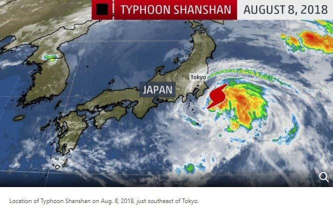
tracked toward Japan and brushed parts of mainland Japan, Honshu, on Wednesday and Thursday as the equivalent of a Category 1 hurricane.
It never made landfall but did bring strong winds and locally heavy rainfall to the region, including Tokyo.
Chichibu, Japan, received almost 7 inches of rainfall, and gusts up to 60 mph were measured along the coast in Chiba Prefecture, east of Tokyo.

© The Weather Channel (screen capture)
Japan received a glancing blow from Shanshan just 10 days after
Typhoon Jongdari impacted the country.
Jongdari took an unusual path, tracking northwestward toward Japan. It made landfall on July 29 in Mie Prefecture as the equivalent of a Category 1 hurricane with maximum sustained winds of 80 mph.
Shanshan, however, took more of a familiar track as it turned toward the northeast as it approached.
Reader Comments
to our Newsletter