The wide range in fatality estimates is because many of the deaths occurred as a result of famine and disease following the flood itself. The exact figures for each source of fatalities remains obscure. If the high-end figure of 230,000 is correct, then the event would rank as not only the fourth-deadliest tropical storm on record but perhaps the sixth-deadliest natural disaster of any kind since 1900. The caveat to these kinds of listings, however, is that when tremendous numbers like this are involved there are huge discrepancies in the range of fatalities attributed to each event (as was the case with the Banqiao Dam disaster). These discrepancies can be seen in Wikipedia's list of the top 10 deadliest natural disasters since 1900. The list uses the highest estimate for the Banqiao Dam disaster.
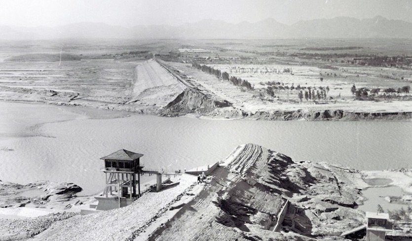
The Banquao Dam was constructed with the help of Soviet consultants in 1951 as a project to control flooding and generate electricity. It was designed to survive a "once in 1000 years" return rainfall event (the area normally receives about 1000mm/40" of rainfall a year) which was calculated as being 300 mm (11.81") of rainfall over 24 hours. In reality, that much rain fell in just two hours during the 1975 storm, with following maximum precipitation point rainfalls measured:
Comment: We're seeing similar record rainfall patterns nowadays. From just this month:
- Floods Everywhere: Europe Battered By Sheets Of Rain, Hail and Thunderstorms
- Two years after '1-in-1,000-year event' floods Maryland, Ellicott City and Baltimore inundated AGAIN
- Cyclone Mekunu leaves at least 10 dead as it batters Oman and Yemen, dumps three years' worth of rain in one day
189.5 mm (7.46") in 1 hour
494.6 mm (19.47") in 3 hours
830.0 mm (32.68") in 6 hours (world record)
954.4 mm (37.57") in 12 hours
1060 mm (41.73") in 24 hours
1629 mm (64.13") in 3 days
The construction and maintenance of the dam was clouded by controversy, with one of China's leading hydrologists, Chen Xing, who was involved in the dam's design and construction, concerned that not enough sluice gates had been installed. He was removed from the project. The website internationalrivers.org has a detailed history of the dam project and its failure. The disaster was a major embarrassment for the government, and some details were considered classified information until the year 2005. This is the reason that so few people understood the true nature of the calamity until just recently.
Maximum point rainfalls
One of the most critical issues facing hydrologists and engineers is calculating what the "worst case" scenario might be in terms of rainfall when they are tasked with the construction of dams and other infrastructure projects. In general they want to know what the heaviest rainfall for specific periods of time might be over the course of the projected life of the structure(s). In other words, if the dam is expected to stand without reconstruction for 100 or 200 years, then they must know what the maximum amount of rain might be in a "once in a 100- or 200-year" storm. These time spans are often called return periods or recurrence intervals; they are meant to convey probabilities and not to imply that such rains would be guaranteed to occur in those time frames.
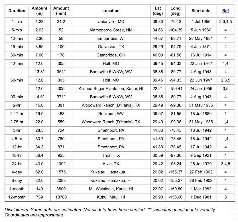
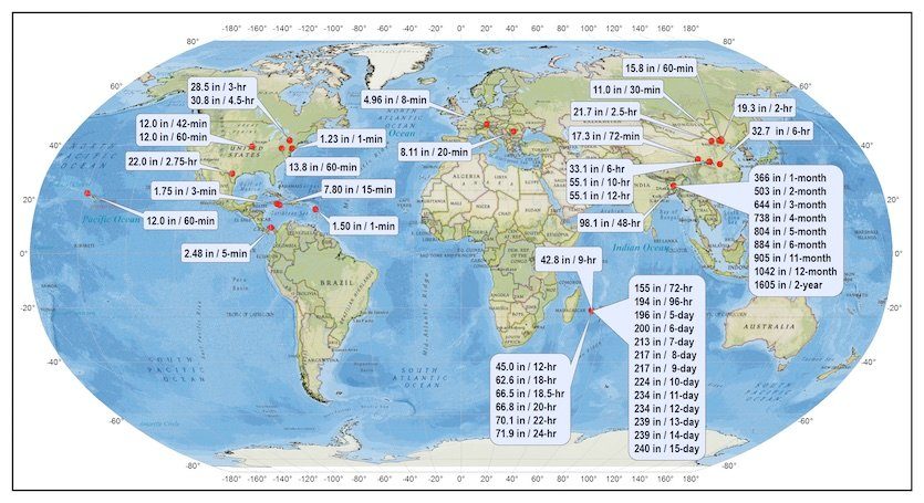
In the U.S., the Hydrometeorological Design Studies Center at the NOAA/NWS Office of Water Prediction publishes tables of extreme maximum point precipitation totals for various time periods for both the U.S. and the world. Below is the latest incarnation of those tables (which are being updated at this time):
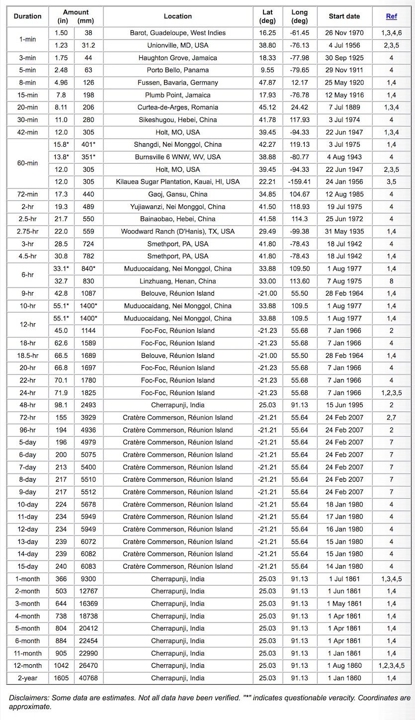
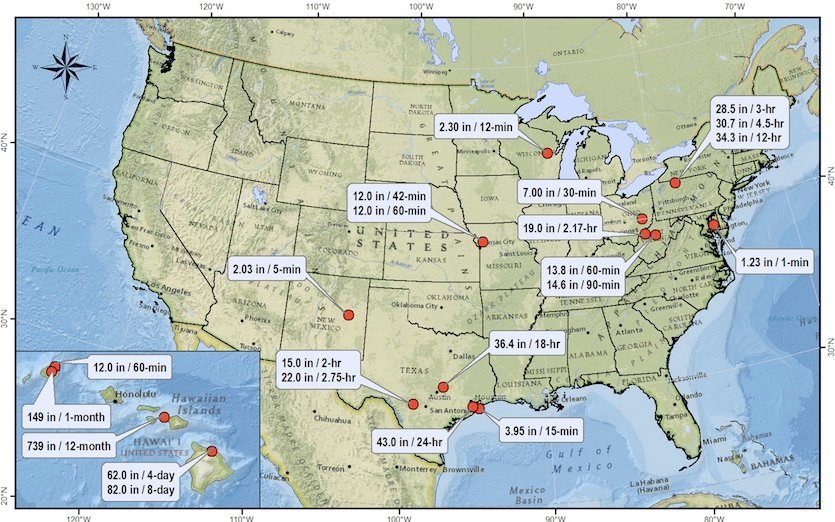
As I mentioned above, these tables are currently under review (I am assisting). Pending verification, a new U.S. record for 24-hour rainfall may have just recently been set in Hawaii: 49.69" at Waipa, Kauai on April 14-15 last month. The HDSC uses data like this to help formulate precipitation frequency estimates and probable maximum precipitation amounts for each region and state in the U.S. See the HDSC website for this information. This has recently been a controversial subject, with many scientists attributing global warming with increased precipitation rates and consequent flooding events. As we have witnessed, several "once in 100 or 500 year" precipitation events have occurred in the same area (i.e. Houston, Texas and, just recently, Ellicott City, Maryland) in just the span of a decade or so.
Comment: AGW doesn't exist. Our planet is undergoing serious cooling with cold records being broken on every continent and, interestingly, this pattern of cooling and devastating floods was documented during the little ice age.

There are clear signs of a nationwide increase in extreme rainfall events. Chapter 7 of the 2017 USGCRP Climate Science Special Report, "Precipitation Change in the United States", posited the following, "Analyses of precipitation extreme changes over the United States by region (20-year return values of seasonal daily precipitation over 1948-2015, Figure 7.2) show statistically significant increases consistent with theoretical expectations and previous analyses. Further, a significant increase in the area affected by precipitation extremes over North America has also been detected. There is likely an anthropogenic influence on the upward trend in heavy precipitation, although models underestimate the magnitude of the trend."
Comment: It appears weather models are quite unprepared for the kind of weather we have in our future:
- Jams in the jet stream blamed for abnormal weather patterns, baffle forecasters
- Is the Gulf Stream about to collapse and is the new ice age coming sooner than scientists think?
- Extreme winter storms and wave heights have been increasing over the last 70 years in the Western Europe
Another graphic in the report (Fig. 7.3) illustrates the incidence of 2-day precipitation events in the U.S. that exceed their 5-year recurrence intervals and how this has dramatically increased since the 1990s:
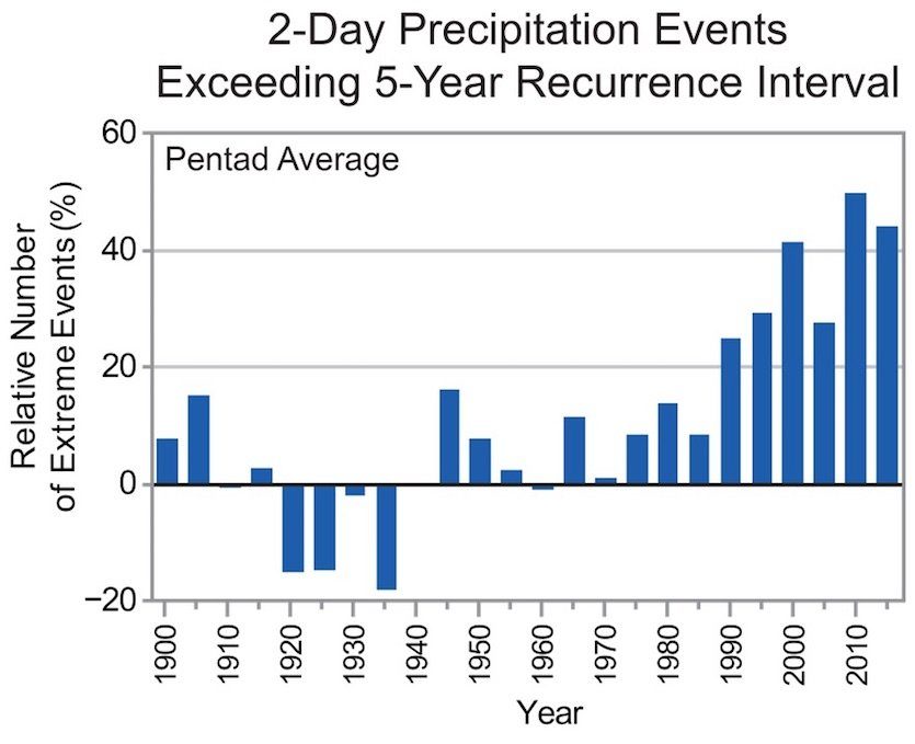
"Heavy precipitation events in most parts of the United States have increased in both intensity and frequency since 1901 (high confidence). There are important regional differences in trends, with the largest increases occurring in the northeastern United States (high confidence). In particular, mesoscale convective systems (organized clusters of thunderstorms)-the main mechanism for warm season precipitation in the central part of the United States-have increased in occurrence and precipitation amounts since 1979 (medium confidence)."
Christopher C. Burt
Weather Historian
The Weather Company's primary journalistic mission is to report on breaking weather news, the environment and the importance of science to our lives. This story does not necessarily represent the position of our parent company, IBM.
Christopher C. Burt Christopher C. Burt is the author of "Extreme Weather; A Guide and Record Book." He studied meteorology at the University of Wisconsin-Madison.


Comment: Meanwhile in just the last 12 months: