The common kilobyte became the magnificent megabyte and this was superseded by the glorious gigabyte.
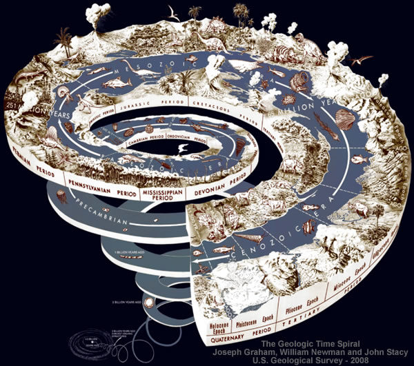
The ZX Spectrum was launched on 23 April 1982, priced at £125 for the 16 KB RAM version and £175 for the 48 KB version.These technological advances follow in the footsteps of the Gradualist Geologists who have [in theory] exponentially elongated the Age of the Earth from an anaemic "few millennia" to a blistering 4.54 billion years old.
...
In 1984, IBM introduced the IBM Personal Computer/AT (more often called the PC/AT or AT) built around the Intel 80286 microprocessor. This chip was much faster, and could address up to 16MB of RAM but only in a mode that largely broke compatibility with the earlier 8086 and 8088.
https://en.wikipedia.org/wiki/History_of_personal_computers
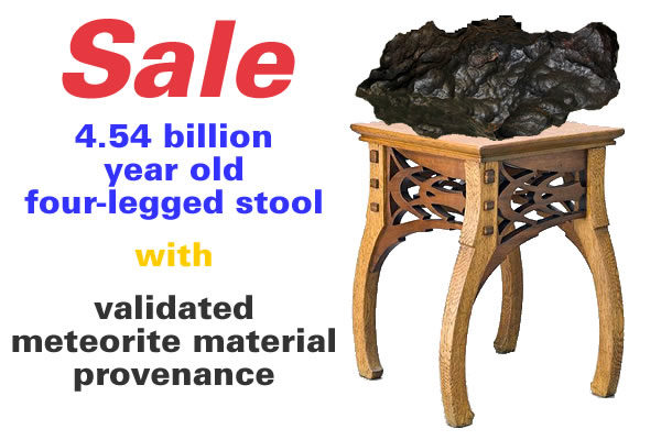
The Ussher chronology is a 17th-century chronology of the history of the world formulated from a literal reading of the Old Testament by James Ussher, the Archbishop of Armagh (Church of Ireland). The chronology is sometimes associated with young Earth creationism, which holds that the universe was created only a few millennia ago by God as they believe is described in the first two chapters of the biblical book of Genesis.The ever inventive Gradualist Geologists justify this exponential increase by referencing the dating of extraterrestrial "meteorite material".
https://en.wikipedia.org/wiki/Ussher_chronology
In 1862, the physicist William Thomson, 1st Baron Kelvin published calculations that fixed the age of Earth at between 20 million and 400 million years
...
The age of the Earth is 4.54 ± 0.05 billion years (4.54 × 10⁹ years ± 1%).
https://en.wikipedia.org/wiki/Age_of_the_Earth
This dating is based on evidence from radiometric age-dating of meteorite material and is consistent with the radiometric ages of the oldest-known terrestrial and lunar samples.Having adopted such an elastic approach to elapse times the Gradualist Geologists are discovering the Real World isn't quite as flexible as they would like when it comes to stretching the truth.
https://en.wikipedia.org/wiki/Age_of_the_Earth
The Himalayan Problem
The Gradualist Geologists working on the Himalayas decided they're "one of the youngest mountain ranges" and assigned an age of somewhere between 40 and 50 million years old.
This implies Mount Everest has been rising at an average rate of between 0.18 and 0.22 mm per year for the last 40 or 50 million years.The Himalayan range is one of the youngest mountain ranges on the planet and consists mostly of uplifted sedimentary and metamorphic rock.
...
During the Upper Cretaceous, about 70 million years ago, the north-moving Indo-Australian plate (which has subsequently broken into the Indian Plate and the Australian plate) was moving at about 15 cm per year.
About 50 million years ago this fast moving Indo-Australian plate had completely closed the Tethys Ocean, the existence of which has been determined by sedimentary rocks settled on the ocean floor, and the volcanoes that fringed its edges.
...
The 6,000-kilometre-plus journey of the India landmass (Indian Plate) before its collision with Asia (Eurasian Plate) about 40 to 50 million years ago.
https://en.wikipedia.org/wiki/Himalayas#Geology
This is a problem because the Himalayas are currently "rising by about 5 mm per year".Mount Everest, also known in Nepal as Sagarmāthā and in China as Chomolungma, is Earth's highest mountain. Its peak is 8,848 metres (29,029 ft) above sea level.
https://en.wikipedia.org/wiki/Mount_Everest
The problem is underlined by the Gradualist Geologists own rulebook which states they should not invoke anything that "cannot presently be observed".The Indian plate is still moving at 67 mm per year, and over the next 10 million years it will travel about 1,500 km into Asia.
About 20 mm per year of the India-Asia convergence is absorbed by thrusting along the Himalaya southern front.
This leads to the Himalayas rising by about 5 mm per year, making them geologically active.
https://en.wikipedia.org/wiki/Himalayas#Geology
In other words:In the natural sciences, gradualism is the theory which holds that profound change is the cumulative product of slow but continuous processes, often contrasted with catastrophism. The theory was proposed in 1795 by James Hutton, a Scottish geologist, and was later incorporated into Charles Lyell's theory of uniformitarianism.
...
Using uniformitarianism, which states that one cannot make an appeal to any force or phenomenon which cannot presently be observed (see catastrophism), Darwin theorized that the evolutionary process must occur gradually, not in saltations, since saltations are not presently observed, and extreme deviations from the usual phenotypic variation would be more likely to be selected against.
https://en.wikipedia.org/wiki/Gradualism
The Gradualist Geologists can't have their fudge cake and eat it.
According to their rulebook Mount Everest should be [as a first approximation] 1,769,600 years old because it's currently observed to be "rising by about 5 mm per year".
Furthermore, if this growth rate results from the kinetic collision of India with Asia then it's safe to assume this growth rate was much higher historically.
The sedimentary rock was slightly metamorphosed from its original deposition and then lifted upward at an amazingly speedy rate - as much as 4.5 inches (10 centimeters) a year as the Himalayas rose.Therefore, a second approximation based upon an average uplift rate derived from the current 5 mm year and the referenced 4.5 inches per year [114.3 mm per year] implies the majestic 8,848 metres of Mount Everest emerged in only 148,332 years at an average rate of 59.65 mm per year.
Geology of Mount Everest - Stewart Green - 3 Nov 2016
https://www.thoughtco.com/geology-of-mount-everest-755308
The Himalayan Fudge
The Gradualist Geologists huddled together and decided to balance the books by offsetting the 5 mm per year rise with some good old fashioned erosion.
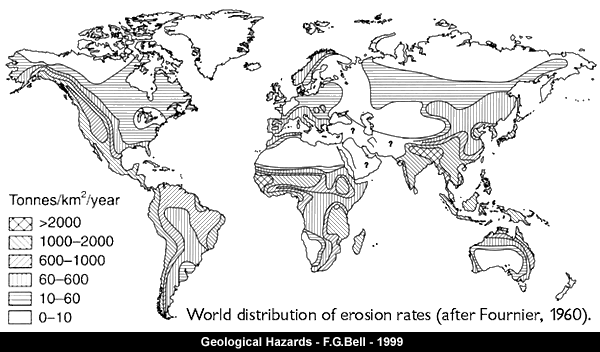
In earth science, erosion is the action of surface processes (such as water flow or wind) that remove soil, rock, or dissolved material from one location on the Earth's crust, then transport it away to another location.Back in the 1960s the Gradualist Geologists very unhelpfully suggested the erosion rate for the Himalayas was greater than 2,000 tonnes per square kilometre per year. Nowadays, the Gradualist Geologists deploy colourful dots to suggest the erosion rates for the last 2 million years.
https://en.wikipedia.org/wiki/Erosion
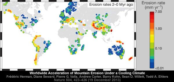
Overall, it appears the Gradualist Geologists are trying to balance the books by suggesting the Himalayas are rising at a rate of 5 mm per year while simultaneously being eroded at a rate of just under 5 mm per year e.g. 5.00 - 4.82 = 0.18 mm per year.
The Everest Challenge
Applying this Himalayan Fudge to Mount Everest produces some interesting results.
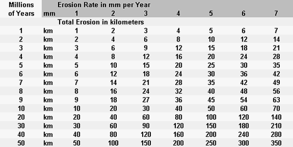
If Mount Everest has been rising at a rate of 5 mm per year for the last 2 million years then it's risen [before accounting for erosion] by 10 kilometres during this period.
Applying this scenario to the whole 50 million year period implies Mount Everest has risen [before accounting for erosion] by a staggering 250 kilometres.
When the growth is offset by erosion then 9.64 kilometres have been shaved off the top of Mount Everest during the last 2 million years and the growth nets out to just 0.36 kilometres.
This implies about 241 kilometres have been shaved off the top of Mount Everest [and the Himalayas] during the last 50 million years.
Either way:
These numbers are especially challenging because the summit of Mount Everest is composed of marine limestone that's only been found in layers "hundreds of feet thick".
An often-cited fact used to illustrate this process is that the summit of Mount Everest is made of marine limestone from this ancient ocean.Rongbuk Reality Check
https://en.wikipedia.org/wiki/Himalayas#Geology
Limestone is a sedimentary rock, composed mainly of skeletal fragments of marine organisms such as coral, forams and molluscs. Its major materials are the minerals calcite and aragonite, which are different crystal forms of calcium carbonate (CaCO3).
https://en.wikipedia.org/wiki/Limestone
Sedimentary limestone deposits can be extensive, covering hundreds of square miles, and can be relatively uniform in thickness and quality. Therefore, limestone quarries can be large and long lived, mining limestone layers that can be hundreds of feet thick over areas of several square miles.
USGS Fact Sheet - Limestone - https://pubs.usgs.gov/fs/2008/3089/fs2008-3089.pdf
The Qomolangma Formation, also known as the Jolmo Lungama Formation or the Everest Formation, runs from the summit to the top of the Yellow Band, about 8,600 m (28,200 ft) above sea level.
It consists of greyish to dark grey or white, parallel laminated and bedded, Ordovician limestone inter layered with subordinate beds of recrystallised dolomite with argillaceous laminae and siltstone.
https://en.wikipedia.org/wiki/Mount_Everest
One 150-foot-thick layer at the bottom of the summit pyramid contains the remains of micro-organisms including cyanobacteria, deposited in shallow warm water.
Geology of Mount Everest - Stewart Green - 3 Nov 2016
https://www.thoughtco.com/geology-of-mount-everest-755308
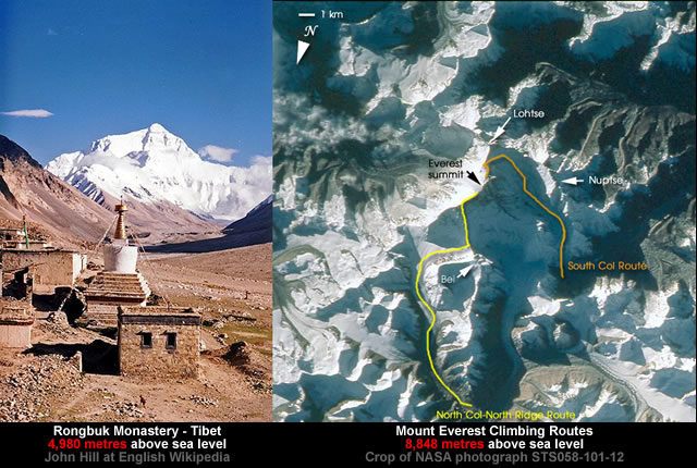
The Rongbuk Monastery nestles in a valley at 4,980 metres above sea level and provides some insights into the erosion rates associated with Mount Everest.
Rongbuk Monastery, also known as Dzarongpu or Dzarong, is a Tibetan Buddhist monastery of the Nyingma sect in Basum Township, Dingri County, in Shigatse Prefecture of the Tibet Autonomous Region in China.If the average net growth rate of 0.18 mm per year is accepted then it would take 21,500,000 years to erode away the 3,868 metres that separates the peak of Mount Everest from the Rongbuk Monastery valley floor.
https://en.wikipedia.org/wiki/Rongphu_Monastery
Alternatively, if it's assumed the Rongbuk Monastery valley floor has been eroding away at a relative rate of 4.82 mm per year then these 3,868 metres of separation are eroded in 802,490 years.
This period is further reduced to only 386,800 years if it's assumed the valley floor has been eroding away at a relative rate of 10 mm per year.
As they say: The Devil is in the detail.
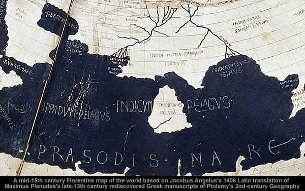
And one of the more devilish details the Gradualist Geologists prefer to ignore is the cartographic evidence that suggests Southern Indian collided with Asia less than 2,000 years ago.





You don't and won't see conventional academics undertaking a serious, objective review of the challenges of historical dating. Just like you won't ever see a time when 'conventional' medicine will conduct an objective investigation into homeopathy. Crop circles? Vaccines? This sort of crowd would never expose themselves to outside critical contradiction. It's proper to view this one issue in the larger context of those matters - mutandis mulatis - of a similar character. The larger perspective makes for clearer understanding.
All advances with respect to historical dating will have to come from outside academia and so there will be an ongoing pissing match about authority. Now you better understand Giodorno Bruno.