China's grip on North Korea's economy
The Trump administration has pressured China to do more to rein in North Korea, which sends most of its exports to its giant neighbour across the Yellow Sea. We take a look at the impact of China's recent ban on North Korean coal and other ways Pyongyang relies on China. - May 4, 2017But the data Reuters uses is unreliable and the news agency is drawing dubious conclusions from it. Such reporting by an official news agency can easily lead to wrong assumptions in the political sphere and to unhelpful if not dangerous policies.
Reuters uses public available data from the Automatic Identification System (AIS) of DPRK ships to identify their destination and load conditions, But the only "automatic" data AIS is transmitting from the ship's transponder to other ships and land stations is position, direction and speed. Even these can be spoofed or be wrong for various reasons. Other AIS data is entered manually into the AIS systems and is often false. Wikipedia notes of AIS data types:
Message 5: Static and Voyage Related Data - Gives information on a ship and its trip - One of the few messages whose data is entered by hand. This information includes static data such as a ship's length, width, draft, as well as the ship's intended destinationUsing open source data, Reuters looks at ships involved in coal exports from the DPRK to China using AIS derived data.
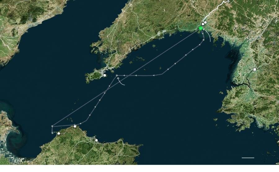
Of the North Korean vessel Hae Bang San it writes:
This vessel departed two Chinese coal handling ports in late April. Ship tracking data showed the bulk carrier was sitting almost one meter lower in the water than its maximum draft of 4.15 meters, indicating it was carrying a heavy load bound for North Korea.The conclusion from that data is that the ship probably did not unload in China but may have loaded up. Such a conclusion is likely wrong because:
- the draft of a ship is manually entered into AIS for each voyage and is often mistyped
- the "maximum draft" of a ship is not registered reliable
- a ship's draft does not say anything about its loading status.
The German ship message board the example is taken from has 28 pages of such "Funny AIS Entries". According to AIS data sailing ships of over 500 meter length are quite common. But a U.S. Homeland Security study found (pdf) that 45% of its 17,000 observed vessels had inconsistencies in their AIS data. 211 of them had "incorrect draft where it is deeper than overall length or beam." Such AIS data is mere garbage.
The Korean vessel Hae Bang San (IMO: 8518962) is listed at fleetmon.com as container vessel with a maximum draft of 5.2 meters. The same ship/IMO is listed as general cargo vessel with a maximum 4.1 meter drought by vesselfinder.com. Marinetraffic.com gives 5 meter drought but no maximum. The sites show a different deadweight for the same ship. Reuters picks some of these public data items, says the vessel is a "bulk carrier" and suggests the ship is overloaded based on data that is inevitably inconsistent. Even if the draft data were correct the ship might have unloaded in China and taken on ballast water to stabilize itself for the home voyage.
We now see more and more of such amateurish and often false "open source" analysis. The unemployed British office administrator Eliot Higgins turned into a hailed "Nonresident Senior Fellow, Digital Forensic Research Lab, Future Europe Initiative of the Atlantic Council". He did so by sitting on his coach musing and blogging about photos of conflict damages found on the Internet. He is no expert in anything. But somehow he always finds a NATO-friendly and anti-Russian interpretation of the incidents he investigates. Higgins has been proven wrong again and again. Amnesty International (which also cheerleads for NATO) uses mere hearsay of two partisan "witnesses" and misinterpreted satellite pictures for claiming mass executions in Syria. During the Georgia war in 2008 Human Rights Watch was caught falsely blaming Russia for cluster bombs used by the Georgian side. The false claim was based on faulty interpretation of open source pictures. Recently Human Rights Watch alleges (pdf) that Russian KhAB-250 ammunition was used in the Khan Sheikhun "Sarin" incident in Syria. The claim is based on amateurish interpretation of public pictures. The alleged ammunition type was never exported from the USSR, never able to contain a chemical weapon load and dismantled in the 1960s.
Open source data is unreliable. It must always be crosschecked and crosschecked again. Pictures and videos are prone to misinterpretation. Humans often see in them what they want to see - not what the pictures really show. Expertise of the domain in question must be consulted before drawing conclusions.
The Reuters report on the North Korea-China coal shipping is likely wrong because the open source data it uses is inconsistent and in general not reliable. No conclusion at all can be drawn from any AIS "Draft" entry. Reuters also uses satellite pictures that show what one wants to see. Are those "coal heaps" Reuters detects in satellite pictures of Chinese harbors really of coal? It is possible but how the hell would it know?
Experts of a field may be able to find truth in open source data. Amateur interpretation of such data by NGOs or none-expert journalists will often be wrong. It is dangerous to report such interpretations in absolute terms and without upfront explicit caveats. Policy decisions based on such propagandistic reports will likely be the wrong ones but are inherently dangerous.


Reader Comments
to our Newsletter