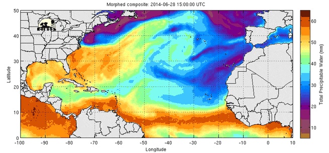
© CIMSSTotal Precipitable Water
On Tuesday morning, the first tropical storm of Atlantic hurricane season was born. A 140-mile stretch of Florida's Atlantic coast is currently under a watch thanks to
Tropical Storm Arthur.
However, the storm is expected to strengthen slightly and could bring some real fireworks to the Mid-Atlantic just in time for the Fourth of July. And by fireworks, we mean drenching rains and the potential for tropical storm-force winds from North Carolina's Outer Banks to the Chesapeake Bay area. There's even a chance Arthur could blossom into a full-fledged hurricane, albeit a weak Category 1 storm, though the strongest winds are likely going to stay out to sea.
The potential of Arthur is still enough to bring Fourth of July festivities to a halt for parts of the Eastern Seaboard. Check out the GIFs below to see if you should keep your beach chairs folded, barbecues covered and fireworks unignited.
The map shows the amount of precipitable water in the atmosphere through Tuesday afternoon. That's basically the measure of water vapor in the atmosphere if you were to condense it and collect it and it gives a rough sense of how much rain could fall. You can clearly see a burnt orange area forming off the east coast of Florida as Arthur draws up moisture. The amount of precipitable water in the atmosphere is only likely to increase as the storm gets ramped up. You can visit the
Cooperative Institute for Meteorological Satellite Studies to see the latest high resolution imagery.
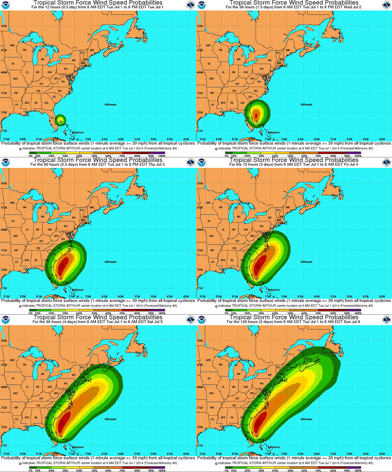
© National Weather ServiceTropical Storm Winds
Arthur's track will scoot right along the coast, which is where the odds of tropical storm-force winds are highest. To be classified tropical storm-force, winds have to be sustained between 39-73 mph. The Outer Banks and other parts of North Carolina's coast have the highest chances of seeing those winds, with odds up to 70 percent. Unfortunately, those winds coincide right with the Fourth of July, meaning fireworks displays could be put on hold.
Big cities further north along the East Coast are less likely to see tropical storm winds. Baltimore, Wasington, D.C., Philadelphia, New York and Boston all have up to a 20 percent chance to experience Arthur's strongest winds by Saturday. You can visit the
National Hurricane Center's Arthur page to see the latest forecast.
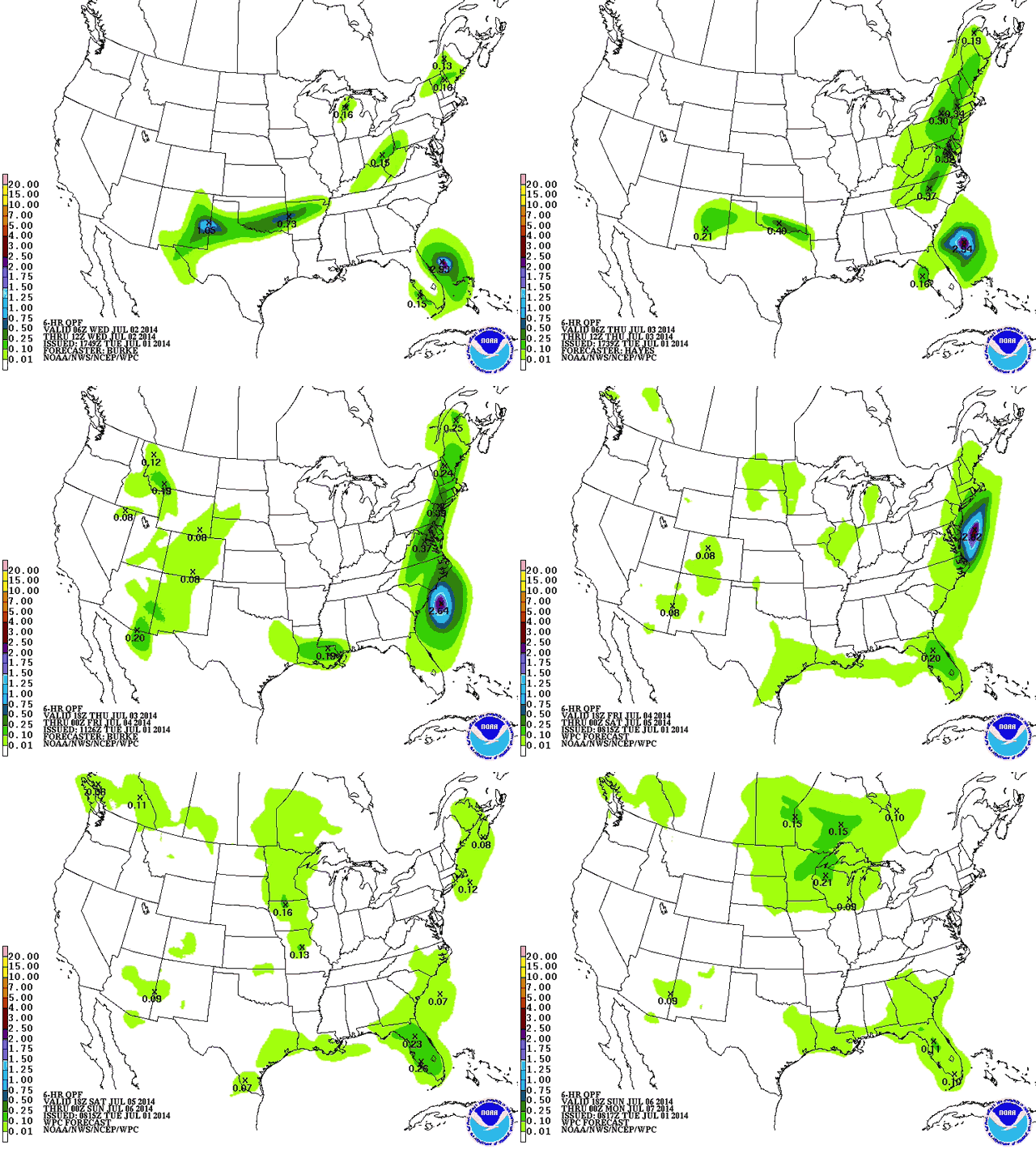
© National Weather ServicePrecipitation Totals
The third strike against Fourth of July in the Outer Banks comes courtesy of Arthur's rain. The National Hurricane Center forecasts rainfall amounts of up to 6 inches for the region, which could fizzle out fireworks displays even if the winds die down. The Northeast again will only get a glancing blow from Arthur's rains. However, a different storm system moving across the U.S. could still bring up to an inch of rain to New York on Thursday. The map above shows 6-hour rainfall totals through Sunday and is updated by the
National Weather Service.
While a Fourth of July without fireworks seems like peanut butter without jelly, it's not always the end of the world. If this looks like something you're considering on the Fourth of July, please visit the
National Council on Fireworks Safety first.


Reader Comments
to our Newsletter