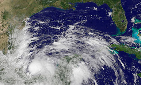
Ingrid strengthened on Saturday after becoming Mexico's second hurricane of the Atlantic storm season, prompting the evacuation of several thousand people while an increasingly powerful tropical storm Manuel threatened to become a hurricane as well, dumping rains that could cause flash floods and mudslides as it nears landfall on Sunday.
On Saturday evening, Hurricane Ingrid was packing maximum sustained winds of 85 mph (140 kph). The storm was centered about 185 miles (300 km) east of Tampico, Mexico and moving north at 7 mph (11 km).
The US National Hurricane Center in Miami said that if Ingrid stays on the forecast track, it is likely to reach the coast of Mexico on Monday. A hurricane warning was in effect from Cabo Rojo to La Pesca.
In Tamaulipas state to the north, where Ingrid is expected to make landfall, the government said in a statement that Independence Day festivities were cancelled in the cities of Tampico, Madero and Altamira. The September 15 and 16 celebrations commemorate Mexico's battle of independence from Spain.
Officials in the Gulf state of Veracruz began evacuating coastal residents on Friday night, and local civil protection authorities said that more than 5,300 people had been moved to safer ground. Of those, about 3,500 people were being housed in official shelters with the rest staying with family and friends. There were no immediate reports of injuries blamed on the storm.
More than 1,000 homes in Veracruz state have been affected by the storm to varying degrees, and 20 highways and 12 bridges have suffered damages, according to the state's civil protection authority.
A bridge collapsed near the northern Veracruz city of Misantla Friday, cutting off the area from the state capital. Thirteen people died when a landslide buried their homes in heavy rains spawned by tropical depression Fernand on Monday.
State officials imposed an orange alert, the highest possible, in parts of southern Veracruz.
Off Mexico's Pacific coast, tropical storm Manuel was also getting stronger, moving with maximum sustained winds of 70 mph (110 kph) and expected to be nearing the southwestern coast of Mexico by Sunday morning, possibly as a hurricane.
Late Saturday, it was about 55 miles (90 kilometers) off the city of Lazaro Cardenas and 180 miles (290 kilometers) southeast of Manzanillo as it moved northward at 6 mph (9 kph). The Mexican government late Saturday issued a hurricane warning for the country's Pacific Coast from Lazaro Cardenas to Manzanillo.
Manuel was expected to produce 10 to 15 inches of rain over parts of the Mexican states of Oaxaca and Guerrero, with isolated amounts of up to 25 inches possible in some areas. Life-threatening flash floods and mudslides were considered likely, especially in mountainous areas.


Reader Comments
to our Newsletter