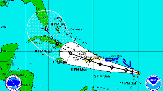
Irene, the ninth named storm of the 2011 Atlantic hurricane season, was expected to pass Puerto Rico's southern coast early on Monday and then strengthen into a hurricane as it approached the Dominican Republic.
It would be the first hurricane of the so far busy, but to date not destructive, 2011 Atlantic hurricane season.
At 8 a.m. EDT, Irene was packing winds of 50 miles per hour and was located about 35 miles west northwest of the French Caribbean island of Guadeloupe, moving into the northeastern Caribbean sea, the U.S.-based National Hurricane Center said.
Residents of Antigua reported rains, strong squalls and surf as the storm passed.
Dominican Republic authorities issued a hurricane warning for the southern coast of the tourism-dependent Caribbean nation, while Puerto Rico declared a hurricane watch.
Tropical storm warnings were in effect for most of the northeastern Caribbean islands, and for Haiti.
"Irene will pass near Puerto Rico tonight or early Monday and approach the Dominican Republic on Monday ... some strengthening is forecast during the next day or so and Irene could become a hurricane on Monday," the Miami-based hurricane center said.
Computer forecast models showed Irene taking a northwestward path over Haiti and eastern and central Cuba and then heading toward the Florida peninsula.
Depending on its eventual path and possible turns, Irene might still pose a threat to U.S. oil and gas installations in the Gulf of Mexico, but forecasters say it is too early to predict with certitude.
Tropical Storm Harvey, which made landfall on the coast of Belize in Central America on Saturday, weakened earlier on Sunday to a tropical depression.
But the NHC said it was still producing heavy rains over Guatemala and southeastern Mexico. It was expected to dissipate later on Sunday or on Monday.
Mudslides and flooding could affect agricultural output in Central America, but this year's coffee and sugar harvests are largely complete.
Reporting by Pascal Fletcher in Miami; additional reporting by Dave Graham in Mexico City, Gustavo Palencia in Honduras and Mike McDonald in Guatemala City


Reader Comments
to our Newsletter